Quite the foggy start this morning for some spots. I was sitting at work this morning and while looking at the GOES16 data happened to notice the explosion of low clouds and fog across Louisiana, Mississippi and Alabama.
The fog will clear out pretty quickly today, but if you are up and at it early, you’ll likely run into some patchy dense fog.
But all eyes are on the weather on Wednesday. Showers and storms are still slated to move through the area during the afternoon and evening. The broad timeline is still 1p through 1a, but a more specific timeline is 4p through 11p.
The Storms Prediction Center has bumped up the Risk to a Moderate Risk. That is a “4” on a 1-to-5 scale where “5” is the highest risk for the most significant severe weather.


The Storms Prediction Center is most concerned about the Wind threat, but as highlighted above, is also concerned about the tornado threat.
The wind risk is sitting at 45-percent and I wouldn’t be surprised if we see a 60% area added later today or tomorrow.
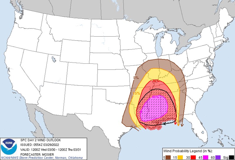
The SPC’s Technical Discussion highlighted the reason for the Wind Risk to be so high. They noted, “Mean wind speeds from the HREF show a corridor of 70 kt at 850 mb from central LA into southeast AR at 18Z. Deep-layer mean winds are forecast to be 65+ kt across much of LA, MS, and AL as the line moves through. Expectation is that these robust wind fields will result in an intense convective line capable of widespread wind damage. Embedded/QLCS tornadoes are also likely within this environment, including the potential for strong tornadoes (EF2+).”
The line of storms set to sweep through the area will stretch all the way into the Gulf. So if you are reading this and asking yourself, “I live in (Louisiana, Mississippi, or Alabama) and I am curious if this will impact me.” The answer is yes.


Embedded within the line will be a few (or more) supercell thunderstorms. These will be capable of producing short-lived (or even long-lived) tornadoes. Last night, I mentioned “brief and weak” tornadoes as a potential from these storms. And I have to amend that this morning, to include “longer-lived and stronger” tornadoes.
It still looks like EF-3 is the top-end in terms of strength, but it also looks like we won’t have to see discrete supercells in order to get a tornado of that strength.
And looking across the three models that we have access to this morning with the Updraft Helicity Streaks, you can see that all three paint streaks across the region.
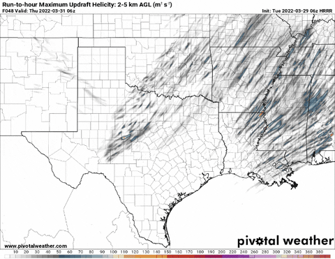
Recall that these “Updraft Helicity Streaks” are when we allow the computer models to try and estimate where they think the strongest storms may develop. And the computer models do this by estimating where the rotating updrafts will develop.
These maps are helpful with generalities, but not specifics. If there is a line moving through your county or over your house, I wouldn’t worry specifically about a storm. But rather, just look at how many there are over the general area around you. Are there a bunch or just one? Just one? okay, so maybe there will be a storm nearby. A bunch? Okay, there is a greater chance a stronger storm impacts your area.
The maps above are a bit more ‘updrafty’ than the previous runs. And even the CIPS Analogs have expanded the potential tornado risk, too.

And I think all of this is tied to the chance for embedded tornadoes within the line. Given that, I have made some minor adjustments to the forecast.
MAIN CONCERNS (spelled correctly today)
||| Between Wed 3p through 11p |||
Brief heavy rain
Localized flash flooding
Frequent lightning
Wind gusts up to 70mph (perhaps higher)
Small Hail
A few tornadoes (one or two strong tornadoes of EF2 or higher)
Today
Patchy fog this morning. Partly sunny by afternoon and a bit breezy. Highs in the mid 80s. South winds 10 to 15 mph.
Tonight
Mostly cloudy. Breezy. Lows in the mid 60s. South winds around 10 mph with gusts up to 20 mph.
Wednesday
Mostly cloudy with showers and storms possible in the afternoon and evening. Some severe. Breezy with highs in the mid 80s. South winds 20 to 25 mph. Gusts up to 45 mph in the afternoon. Chance of rain 70-percent.
Wednesday Night
Mostly cloudy with storms likely before midnight. Some storms may be severe. Breezy with lows in the upper 50s. South winds 20 to 25 mph with gusts up to 45 mph, becoming southwest 5 to 10 mph with gusts up to 30 mph after midnight. Chance of rain near 70-percent.
Thursday
Sunny and still a bit breezy. Less humid with highs in the mid 70s. West winds 10 to 15 mph.
Thursday Night
Mostly clear. Cooler with lows in the upper 40s.
Friday
Mostly sunny. Highs in the mid 70s.
Friday Night
Partly cloudy. A chance of showers after midnight. Lows in the lower 50s. Chance of rain 30-percent.
Saturday
Mostly cloudy with some passing showers and storms. Highs in the upper 70s. Chance of rain 40-percent.
Saturday Night
Partly cloudy. Lows in the lower 50s.
Sunday
Sunny. Highs in the upper 70s.
Sunday Night
Mostly clear. Lows in the upper 40s.
Monday
Sunny. Highs around 80.


