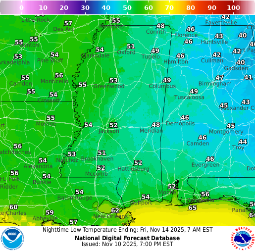
Did your location see temperatures below freezing last night into this morning? Odds are the answer to that question is yes! The trough did indeed reach down into the Pine Belt and brought widespread cold to all of the eastern US, even Florida! Multiple records were broken, including a few spots here in our region. As Nick alluded to in his Facebook post, we tied the record low for Hattiesburg at 26 degrees, but some other “unofficial” spots definitely saw record lows broken.
Overall Setup
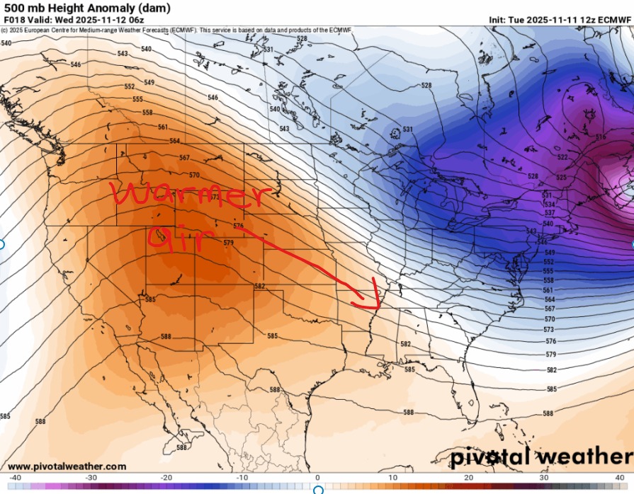
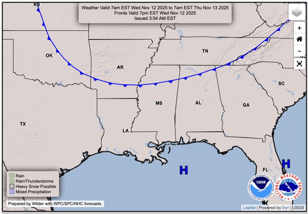
We do have one more night of cold temperatures tonight into tomorrow, but after that we are looking at the large-scale ridging from the west coast making its way to the east, flipping the switch on temperatures. That will also keep it relatively dry through the weekend as well. At least for tomorrow, the surface pattern includes an area of high pressure overhead, and a cold front to the north that will be sliding away.

Tonight’s Forecast
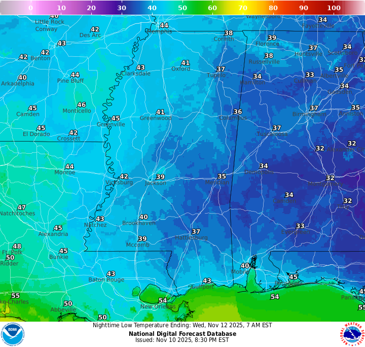
Again, we have one more night of frigid temperatures, maybe not as cold but temps will be in the upper 30s and lower 40s for most. We are free from any rain, and clouds at that, thanks to our area of high pressure.
Tomorrow’s Forecast: Wednesday, November 12
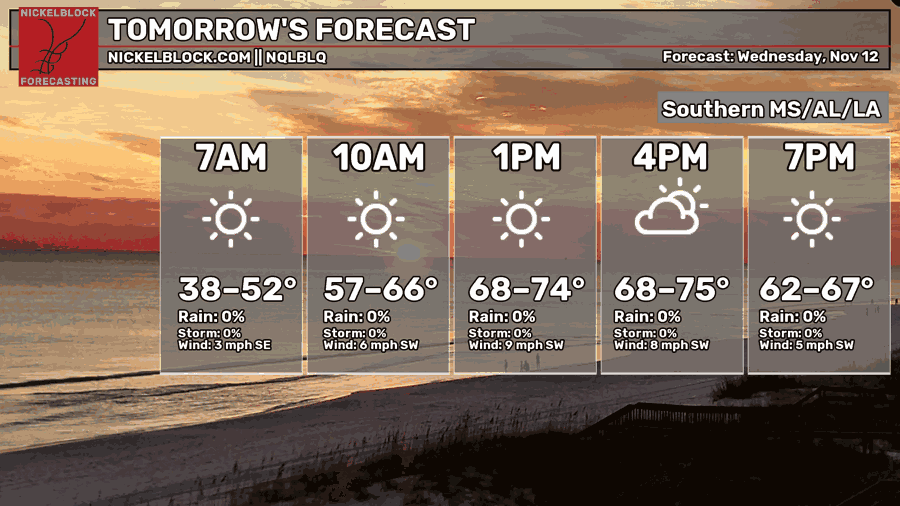
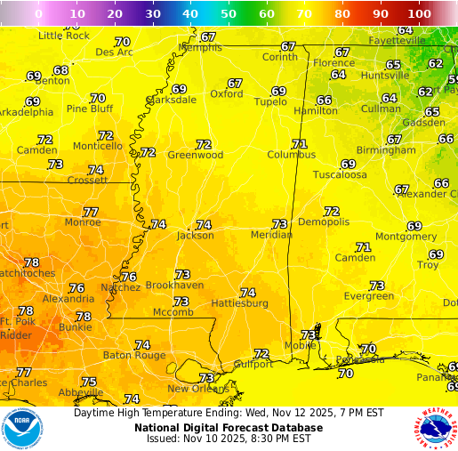
Ensure you are bringing the winter coat and perhaps your hat and gloves on the way to work in the morning! Temperatures will warm up pretty quickly by 10 am, but 30s and 40s will be the temperatures you wake up with. Again, the lack of rain continues into tomorrow, with only some scattered clouds in the area. We do warm up to the upper 60s and lower 70s for Wednesday, so the jacket will not be needed after work. Typical fall!
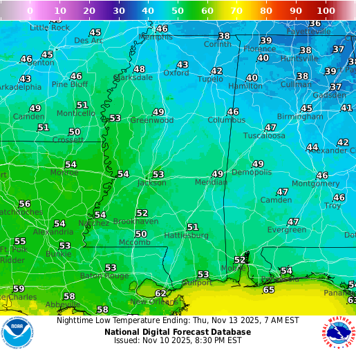
Thursday’s Forecast: November 13
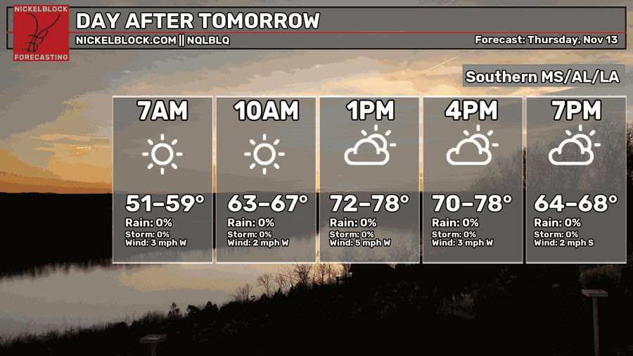
The morning temperatures on Thursday will be much milder than the previous ones, this time in the 50s. Temperatures become much warmer in the mid-to-upper 70s as that ridging slides its way eastward. Skies are partly cloudy with no chance for rain in the forecast.
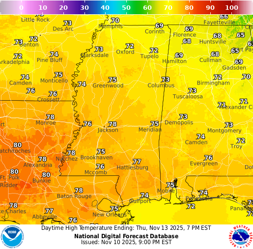
Extended Local Outlook

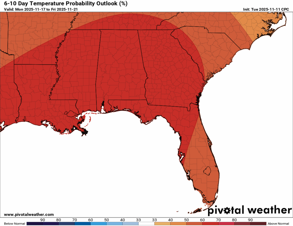
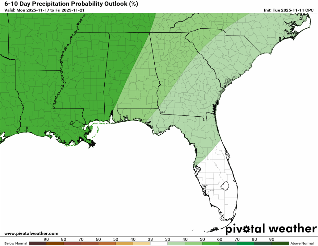
In the 15-day forecast, you can see that we will continue with the dry pattern through the end of the week into the weekend. Temperatures will continue to warm up into the upper 70s and maybe near 80 for some of the days. Into next week, we could see some chances of rain for the early half of the week, which is why the CPC has given us a high chance of above-normal rainfall for our region.

REGIONAL DAY TO DAY FORECAST
Tonight: Mostly clear. Lows in the upper 30s. South-southwest winds around 5 mph, becoming calm in the evening.
Wednesday: Sunny. Highs in the mid 70s. Light and variable winds becoming west-southwest 5 to 10 mph in the morning.
Wednesday Night: Mostly clear. Lows in the lower 50s. Calm wind.
Thursday: Mostly sunny. Highs in the upper 70s. Calm wind becoming west around 5 mph during the day.
Thursday Night: Mostly clear. Lows in the lower 50s. Calm wind.
Friday: Sunny. Highs in the upper 70s. Calm wind becoming south around 5 mph in the afternoon.
Friday Night: Mostly clear. Lows in the lower 50s. South winds around 5 mph, becoming calm in the evening.
Saturday: Mostly sunny and warm. Highs in the upper 70s. Light south wind increasing to 5 to 10 mph in the morning.
Saturday Night: Partly cloudy. Lows in the mid 50s. South winds around 5 mph.
Sunday: Sunny. Highs near 80. Light wind.
Sunday Night: A slight chance of showers. Partly cloudy with lows in the upper 50s. Light wind. Chance of rain 20 percent.
Monday: A slight chance of showers. Mostly sunny with highs in the upper 70s. Chance of rain 20 percent.
Monday Night: A slight chance of showers. Partly cloudy with lows around 60. Chance of rain 20 percent.
Tuesday: A slight chance of showers. Mostly sunny with highs in the upper 60s. Chance of rain 10 percent.


