After a stretch of sunny and steamy days through the weekend, a shift in the pattern brings increasing rain chances and stormy skies early next week. From Thursday to Saturday, expect classic summer heat with mostly clear skies and just a few stray showers. But by Sunday, moisture from the Gulf moves in, setting the stage for scattered thunderstorms and rising humidity. That unsettled trend continues into Tuesday and Wednesday, with widespread showers, cooler daytime highs, and a soggy finish to the week.
High Pressure Holds: Thursday–Saturday
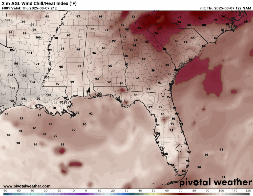
Heat Index values for Thursday from the NAM model. //Courtesy: Pivotal Weather
A broad ridge of high pressure centered over the southeastern U.S. will suppress convective activity and promote mostly sunny conditions across the region. Daytime highs will range from 88°F to 93°F, with heat indices climbing into the upper 90s due to dew points in the low to mid-70s. Winds will be light and variable, generally from the south at 5–10 mph, which will help maintain elevated humidity levels. On Thursday, weak sea breeze boundaries may trigger isolated showers near the Gulf Coast, but vertical instability remains limited. Friday and Saturday will see stronger subsidence aloft, which will reduce cloud cover and keep rain chances low. Overnight lows will stay warm, in the 74–78°F range, with patchy fog possible in low-lying areas during early morning hours.
Moisture Surge: Sunday–Monday
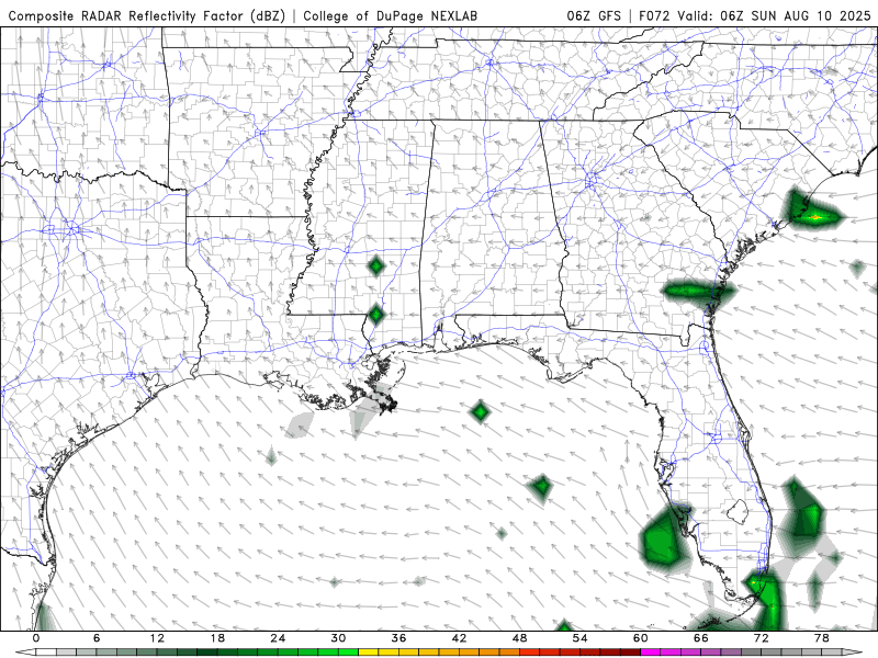
Radar for Sunday-Monday from the GFS model. //Courtesy: College of DuPage
A shift in the upper-level pattern allows deeper Gulf moisture to stream northward, increasing precipitable water values to around 1.8–2.0 inches. This surge in low-level moisture, combined with daytime heating and weak upper-level impulses, will enhance convective development. Expect scattered showers and thunderstorms, especially during the afternoon and evening hours, with rain chances rising to 40–60%. Highs will remain in the upper 80s to low 90s, but cloud cover and rain-cooled air may keep some areas slightly cooler. CAPE values will range from 1500–2500 J/kg, supporting moderate thunderstorm intensity, though severe weather is not expected. Lightning, brief downpours, and gusty winds are possible in stronger cells. Overnight lows will dip into the mid-70s with continued high humidity and occasional light rain lingering into the early morning.
Unsettled Midweek: Tuesday–Wednesday

500 mb map for Tuesday of next week from the GFS model. //Courtesy: College of DuPage
A weak upper-level trough will settle over the Deep South, enhancing lift and destabilizing the atmosphere. This feature, combined with saturated surface conditions and elevated moisture profiles, will sustain daily rounds of showers and thunderstorms. Rain chances will peak between 50–60%, with widespread cloud cover limiting daytime heating. Highs will range from 85°F to 89°F, and dew points will remain oppressive in the mid-70s. Storms may initiate earlier in the day due to increased cloud cover and residual outflow boundaries from previous convection. PWAT values near 2.2 inches suggest locally heavy rainfall is possible, especially in slow-moving or training cells. Flash flooding is not expected, but could occur in urban areas with poor drainage. Winds will be light, generally from the southeast, and overnight lows will stay in the low to mid-70s with lingering showers and elevated cloud cover.
Regional Day-to-Day Forecast
Thursday – Mostly sunny and hot. Highs 90–94°F. Humid with dew points in the upper 70s°F. South winds 5–10 mph. A few coastal showers possible in the afternoon.
Thursday Night – Mostly clear. Lows 75–78°F. Light winds. Patchy fog may develop inland.
Friday – Sunny and steamy. Highs 92–96°F. Heat index values near 105°F. South winds 5–10 mph. Isolated sea breeze storms possible late afternoon.
Friday Night – Mostly clear. Lows 74–77°F. Calm winds. Coastal showers may linger.
Saturday – Mostly sunny with isolated afternoon storms. Highs 91–95°F. Humid with dew points in the upper 70s°F. West winds 5–10 mph. Storms may bring brief downpours and gusty winds.
Saturday Night – Partly cloudy. Lows 73–76°F. Light winds. Coastal showers possible.
Sunday – Partly sunny with scattered afternoon thunderstorms. Highs 88–92°F. Muggy with dew points in the upper 70s°F. Southwest winds 5–10 mph. Storms may be locally heavy.
Sunday Night – Mostly cloudy. Lows 72–75°F. Light winds. Isolated showers and patchy fog late.
Monday – Mostly cloudy with scattered storms. Highs 87–90°F. Humid with dew points in the mid to upper 70s°F. Winds southwest 5–10 mph. Rain chances increase by afternoon.
Monday Night – Cloudy with lingering showers. Lows 71–74°F. Light winds. Fog possible inland.
Tuesday – Partly sunny with isolated afternoon storms. Highs 89–93°F. Humid with dew points near 77°F. Winds west 5–10 mph. Storms may bring brief downpours.
Tuesday Night – Mostly clear. Lows 74–78°F. Light winds. Coastal showers possible.
Wednesday – Mostly sunny with scattered storms developing late. Highs 90–94°F. Dew points in the upper 70s°F. Winds southwest 5–10 mph. Storms may be gusty.
Wednesday Night – Partly cloudy. Lows 73–76°F. Light winds. Isolated showers near the coast.


