The Gulf Coast remains entrenched in a classic early summer pattern, dominated by intense solar insolation, abundant tropical moisture, and weak synoptic steering. Despite the passing of the solstice, the atmosphere is far from stable. The combination of high surface temperatures, ample boundary layer moisture, and diurnal heating will continue to destabilize the lower troposphere, fueling daily rounds of convection. Through the weekend, expect scattered to numerous afternoon thunderstorms, especially inland and along mesoscale boundaries. By early next week, a strengthening mid-level ridge will begin to suppress vertical motion, gradually reducing storm coverage and increasing heat stress.
Diurnal Heating and Boundary Layer Instability Drive Afternoon Convection
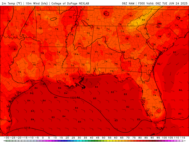
Diurnal Temperatures from Tuesday to Friday from the NAM model. //Courtesy: College of DuPage
Surface temperatures across southern Louisiana, Mississippi, and Alabama will consistently climb into the upper 80s to mid-90s°F, with heat indices peaking between 100–110°F due to high humidity. This intense heating destabilizes the boundary layer, with CAPE values frequently exceeding 2000 J/kg, creating a favorable environment for vigorous afternoon convection. Thunderstorms will initiate along sea breeze fronts, outflow boundaries, and zones of differential heating, typically erupting between 1 and 4 PM local time. While storms will be scattered in nature, their intensity may be locally enhanced by mesoscale interactions. This pattern will continue through the week and into the weekend.
Deep Tropical Moisture Enhances Rainfall Efficiency and Flood Risk
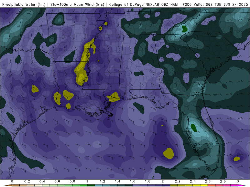
Precipitable Water values from Tuesday to Friday from the NAM model. //Courtesy: College of DuPage
A persistent southerly flow from the Gulf continues to transport maritime tropical air into the region, maintaining dewpoints in the mid-70s°F and precipitable water values near 2 inches. This saturated vertical profile supports high rainfall efficiency, with storms capable of producing rainfall rates exceeding 2 inches per hour. The risk of localized flash flooding is elevated, particularly in urbanized areas, low-lying terrain, and poorly drained locations. In addition to heavy rain, storms will be accompanied by frequent cloud-to-ground lightning, posing a hazard to outdoor activities.
Weak Shear Limits Organization, but Mesoscale Boundaries Enhance Storm Dynamics
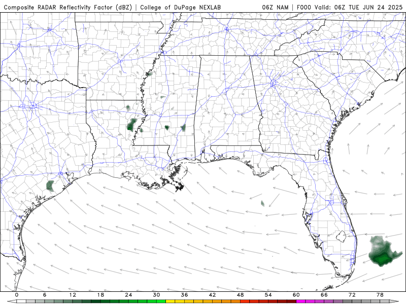
Composite Radar from Tuesday to Friday from the NAM model. //Courtesy: College of DuPage
Despite weak vertical wind shear (<20 kt), which favors pulse-type convection, mesoscale processes will play a key role in storm evolution. Outflow boundary collisions, sea breeze convergence, and terrain-induced circulations will locally enhance lift and storm organization. While widespread severe weather is not anticipated, isolated strong storms may produce gusty winds (40–50 mph) and small hail, particularly where boundary interactions enhance updraft strength. The primary threats remain brief downpours, frequent lightning, and localized wind damage.
Ridge Amplification Brings Suppression, Heat, and Heightened Thermal Stress
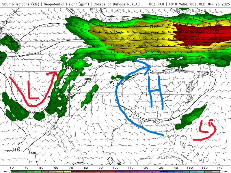
500 mb map for Tuesday from the NAM model. //Courtesy: College of DuPage
This week, a 500 mb ridge centered over the Southeast U.S. will begin to amplify and expand westward, promoting subsidence, drying aloft, and the development of a capping inversion. This synoptic evolution will gradually suppress convective development. However, the reduction in cloud cover and rainfall will allow temperatures to rise further, with highs in the low to mid-90s°F and heat indices approaching 110°F. The combination of intense heat, high humidity, and limited relief from thunderstorms will elevate the risk of heat-related illnesses, especially for vulnerable populations. By Thursday, the NAM model shows a weak low pressure system moving into the Gulf of America from the east. This will briefly disrupt the current pattern and increase storm chances for Friday and Saturday. This low will weaken by Sunday, and high pressure will dominate once again.
Regional Day-to-Day Forecast
Tuesday – Partly to mostly cloudy skies with scattered thunderstorms in the morning. High around 90°F. Winds SE at 10–15 mph with a 40% chance of rain.
Tuesday Night – A few clouds from time to time. A stray shower or thunderstorm is possible. Low around 77°F with a 20% chance of rain.
Wednesday – Intervals of clouds and sunshine. High near 91°F. Winds SE at 5–10 mph with a 20% chance of rain.
Wednesday Night – A few clouds from time to time. Low near 77°F. Winds WSW at 5–10 mph with a 20% chance of rain.
Thursday – Partly cloudy skies. High near 90°F. Winds SSE at 10–15 mph with a 20% chance of rain.
Thursday Night – Mostly clear to partly cloudy. Low around 78°F with a 20% chance of rain.
Friday – Scattered thunderstorms in the morning, then partly cloudy late. High near 89°F. Winds S at 10–15 mph with a 40% chance of rain.
Friday Night – Variably cloudy with scattered thunderstorms. Low around 78°F with a 50% chance of rain.
Saturday – Scattered showers and thunderstorms. High near 87°F. Winds SSW at 10–15 mph with a 60% chance of rain.
Saturday Night – Variably cloudy with scattered thunderstorms. Low around 78°F with a 50% chance of rain.
Sunday – Scattered thunderstorms. High near 89°F. Winds SW at 5–10 mph with a 60% chance of rain.
Sunday Night – Partial cloudiness early, with scattered showers and thunderstorms later during the night. Low around 79°F with a 40% chance of rain.
Monday – Scattered showers and thunderstorms. High around 90°F. Winds SW at 10–15 mph with a 50% chance of rain.
Monday Night – Partly cloudy with late night showers or thunderstorms. Low around 79°F with a 50% chance of rain.


