The current weather pattern across southern Louisiana, Mississippi, and Alabama is driven by intense solar heating near the summer solstice, which enhances surface temperatures and atmospheric instability. Persistent southerly winds are advecting warm, moist air from the Gulf of Mexico, raising dew points and creating a deep, saturated boundary layer conducive to convection. This unstable environment, characterized by steep lapse rates and high CAPE values, is periodically influenced by weak upper-level disturbances that enhance vertical motion and trigger thunderstorms. In the absence of strong synoptic systems, such as fronts or tropical cyclones, mesoscale features, including sea breezes and outflow boundaries, dominate storm initiation. Additionally, high humidity and urban heat retention are elevating heat indices to dangerous levels, especially in metropolitan areas, reinforcing the classic early summer convective regime typical of the Gulf Coast.
Seasonal Solar Heating
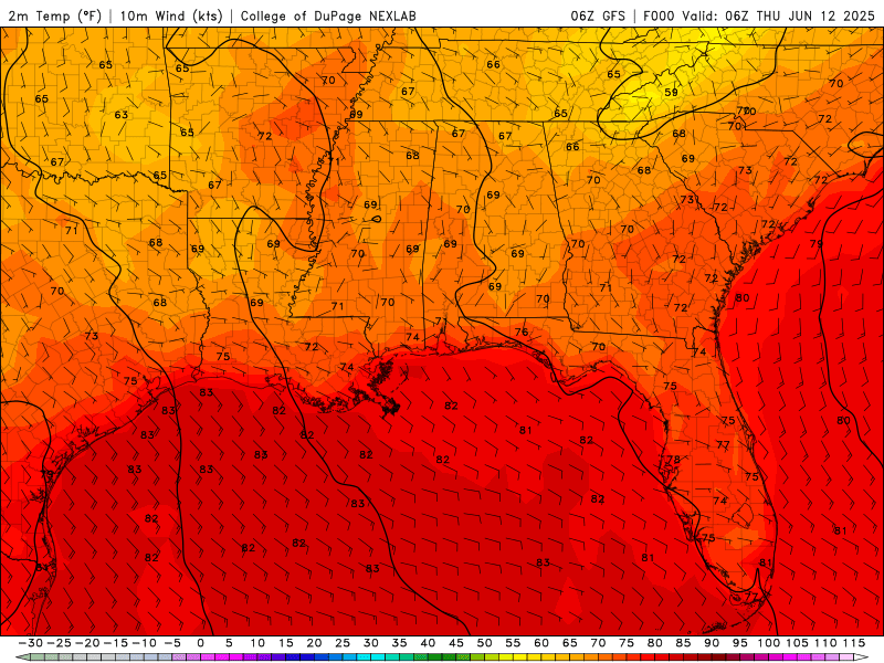
Temperatures for Thursday through Wednesday of next week from the GFS model. //Courtesy: College of DuPage
As the summer solstice approaches around June 21, the sun’s position in the sky reaches its highest point for the year, placing the solar declination nearly overhead at latitudes near 30°N, right over the Gulf Coast region. This alignment results in maximum insolation, or incoming solar radiation, particularly during midday hours. The land surface absorbs this intense solar energy and heats up rapidly, transferring that heat to the air above through conduction and convection. This process deepens the atmospheric boundary layer and significantly increases Convective Available Potential Energy (CAPE), both of which are critical ingredients for the development of afternoon thunderstorms common during this time of year.
Gulf Moisture Feed
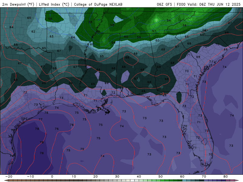
Dew Points for Thursday through Wednesday of next week from the GFS model. //Courtesy: College of DuPage
A persistent low-level southerly flow, typically associated with a Bermuda High or subtropical ridge, continuously transports warm, moisture-laden maritime tropical (mT) air from the Gulf of Mexico into the region. This air mass is characterized by high dew points, often in the mid-to-upper 70s°F, which contribute to a deeply saturated boundary layer extending up to the 850–700 mb level. Such a moist vertical profile is highly conducive to convection, especially when surface heating or other lifting mechanisms are present. Additionally, precipitable water (PWAT) values frequently exceed 2.0 inches, signaling a very moist atmospheric column and a heightened potential for heavy rainfall during convective events.
Atmospheric Instability
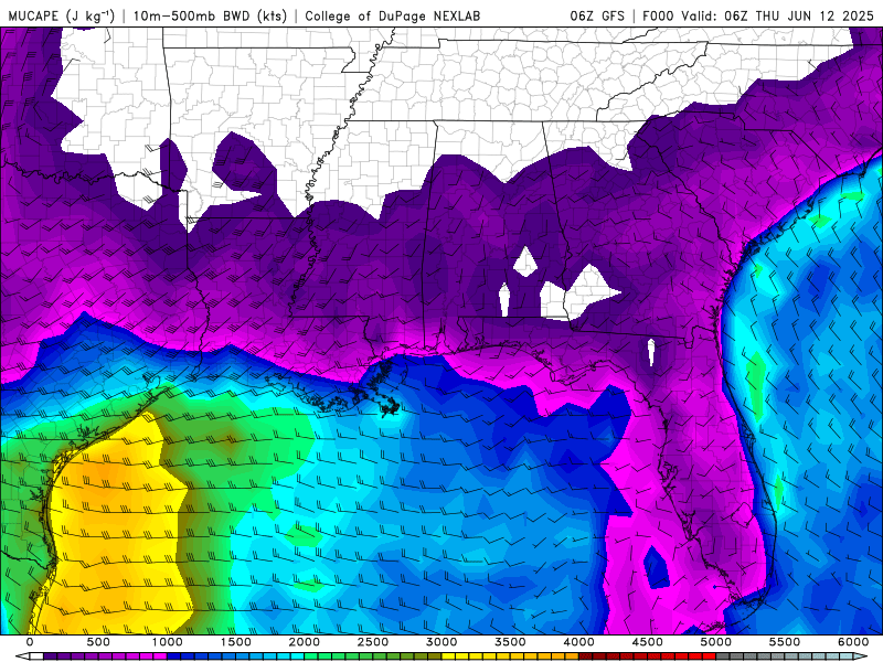
CAPE values(atmospheric instability) for Thursday through Wednesday of next week from the GFS model. //Courtesy: College of DuPage
Atmospheric instability develops when a layer of warm, moist air near the surface is overlain by cooler, drier air aloft, creating a steep lapse rate, meaning temperature decreases rapidly with height. This vertical temperature gradient enhances the buoyancy of air parcels, allowing them to rise freely if they remain warmer than the surrounding environment. As these parcels ascend, they can form deep convection, often resulting in cumulonimbus cloud development and thunderstorms. In such setups, Convective Available Potential Energy (CAPE) values frequently exceed 2000 J/kg, indicating a highly unstable atmosphere capable of supporting strong updrafts and vigorous thunderstorm activity.
Weak Upper-Level Disturbances
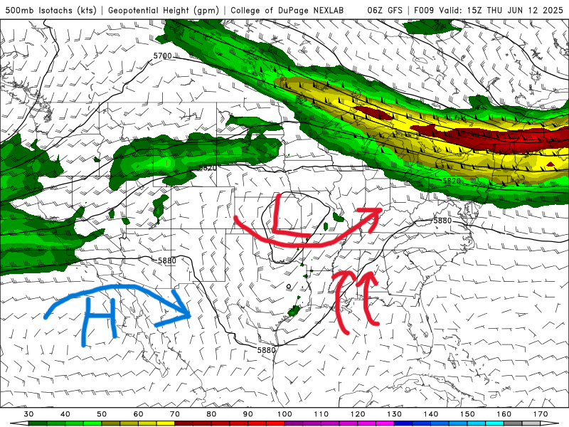
Today (June 12th) 500 mb map from the GFS model. //Courtesy: College of DuPage
Shortwave troughs or vorticity maxima embedded within the mid- to upper-level flow (typically between 500–300 mb) play a subtle yet significant role in atmospheric dynamics. These features contribute to positive vorticity advection (PVA) and differential divergence aloft, both of which enhance large-scale upward motion in the atmosphere. When such disturbances pass over a region characterized by abundant moisture and instability, they can initiate or organize convective activity, even in the absence of strong surface-based forcing mechanisms. This makes them important triggers for thunderstorm development in otherwise weakly forced environments.
Lack of Synoptic Forcing
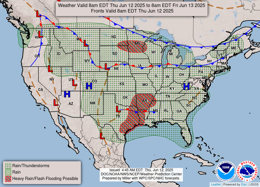
Surface Weather map for today (June 12) //Courtesy: National Weather Service
Currently, no strong synoptic-scale features such as cold fronts, drylines, or tropical systems are influencing the region, allowing mesoscale processes to dominate the weather pattern. In this environment, sea breeze fronts develop daily due to differential heating between land and adjacent Gulf waters, providing localized lift. Additionally, outflow boundaries from previous thunderstorms act like miniature cold fronts, initiating new convection as they collide with warm, moist air. These mechanisms contribute to a diurnally driven convective regime, where thunderstorms typically form during the afternoon peak heating hours and dissipate after sunset as surface instability wanes.
Regional Day-to-Day Forecast
Tonight – Mostly cloudy and warm with a chance of lingering thunderstorms before dawn. The low will be 77°F with southwest winds around 10 mph. Rain chance: 50%.
Friday – Mostly sunny early, then a slight chance of afternoon thunderstorms. High near 88°F. Southwest winds at 10–15 mph. Rain chance: 30%.
Friday Night – Partly cloudy and muggy. Low around 77°F. Light southwest winds. Rain chance: 30%.
Saturday – Partly sunny with isolated afternoon thunderstorms. High near 89°F. Southwest winds at 10–15 mph. Rain chance: 40%.
Saturday Night – Mostly cloudy with a few showers possible late. Low around 77°F. Rain chance: 30%.
Sunday – Intervals of sun and clouds with scattered afternoon storms, especially inland. High near 89°F. Southwest winds at 10–15 mph. Rain chance: 50%.
Sunday Night – Partly cloudy early, with increasing chances of showers and thunderstorms overnight. Low around 78°F. Rain chance: 50%.
Monday – Scattered thunderstorms likely, especially in the afternoon. Some storms may produce heavy rainfall. High near 87°F. Southwest winds at 10–15 mph. Rain chance: 60%.
Monday Night – Showers and thunderstorms likely, especially after midnight. Low around 76°F. Rain chance: 70%.
Tuesday – Mostly cloudy with widespread showers and thunderstorms. Rainfall could be heavy at times. High near 86°F. Light west winds. Rain chance: 90%.
Tuesday Night – Showers and storms likely, tapering off late. Low around 75°F. Rain chance: 60%.
Wednesday – Partly sunny with scattered showers and thunderstorms. High near 86°F. Light south winds. Rain chance: 70%.
Wednesday Night – Mostly cloudy with a chance of evening storms. Low around 76°F. Rain chance: 40%.


