The NWS forecast for tonight and Sunday night feature some pretty chilly temperatures across the Gulf Coast. Here is a look at some of those numbers from Pivotal Weather for tomorrow night (during the eclipse, btw):

Cold as Ice
Temperatures tumbling into the 20s Sunday night means protecting plants, pets, exposed pipes and checking in on people who don’t have easy access to heat. That may be more important than usual this time as the length of time the region will be below freezing may exceed 8 hours in some spots.
It may not be enough to simply move your plants under an eve or awning. You may actually need to bring them indoors. And if they are in the ground, you’ll need to cover them up.
Give pets a place to be that is warm, too. I would recommend inside for the night, but if that isn’t an option, leaving a bed of blankets in an enclosed structure is best. Somewhere that the wind can’t cut through.
And call up friends or family that don’t have easy access to heat and invite them over for the night.
Head Games
But Sunday night’s forecast isn’t why you clicked, is it? No, of course not. With the prospects for precipitation on the horizon, when cold temperatures are in close proximity, the only thing on a Good Southerner’s mind is the ‘S’ word. Or words. Depending on how you feel about it.
Snow, being one of them. And well, I won’t write the other.
There is a chance that some people may see a few ice crystals in the air tonight. A few others may see some flurries, depending on how quickly things dry out.

The sounding data from Tropical Tidbits shows that there may be a brief window between 11pm and 1am for some places in Louisiana, Mississippi and Alabama to see some ice crystals form and fall. These would be very tiny and look a bit like mist. There won’t be any meaningful accumulation – except maybe a glaze on cars – and it won’t bother the roads or travel of any kind. But it might look kinda neat.
But real-deal snow doesn’t look like it’ll happen tonight.
Inside Information
I mentioned during a facebook video on Friday night that if the Gulf Coast were to see snow, it is easiest to do during specific types of setups. And historically, the type of setup that brings the Gulf Coast a chance for snow was being portrayed in one run, of one of the models, at one point during the day, yesterday.
Remember that medium-range computer weather models render a new set of data every six hours. So even when a forecast model shows one outcome at one point, checking back six hours later that data may have changed. the new version isn’t always ‘more correct’ or ‘less correct’ but, rather, all apart of building an accurate forecast
So the question on everyone’s mind is: Is that still the forecast?
Well, not to be a stickler, but that was never the forecast. It was only one model. The better question is, “Does any additional model data support that outcome?”
The answer to that is, at this point, no. In fact, even that model has changed its tune.

The ‘elbow’ in the 500mb map has disappeared from the model that showed it last night. The elbow was just a quick way of pointing out that the main flow up at 18,000 feet was roughly north-to-south coming from Canada and slamming toward the Gulf Coast.
The placement of the elbow was to the west near Dallas that allowed the cold air filter south and allow over-running moisture from the southwest to move through an area where there was already cold air at the surface.
That is the easiest way to get any snow made aloft in the clouds, down to the surface still frozen as snow. And not rain or sleet.
That feature looks more like a bowl now. While there is still a strong trough of low pressure, it isn’t at as much of a right angle anymore, and that right angle is also not to the west near Texas.
That was Yesterday
The change isn’t uncommon. Models tend to change about every six hours. And the forecast models are going to be changing a lot in the coming days. There is a pretty aggressively-cold pattern trying to setup for the eastern United States and Canada. When that happens, it generally sends the computer weather models into a tizzy kicking out data showing places that don’t normally get snow with accumulating snow. Truth be told, the model that showed the outcome on Friday night, could flip back and show that data again. It may find another way to get to the same solution. That isn’t uncommon either.
If it looked more like…
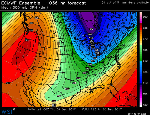
… There would be more of a cause for intrigue. That would allow all the cold air to spill underneath the precipitation. But, as of now, it has disappeared from the model data.
I Have Waited So Long
With two shots for cold air and precipitation, it it tempting to say, there are two “chances” for snow in the region. But, before you get Double Vision, it wouldn’t be completely accurate to say that. Snow is possible, sure, but the chances of snow (given the available data) are incredibly low. Will that change? Probably. Will that change be meaningful enough to give the region a real chance or snow? I can’t answer that with any conviction, no one can. But, history tells me no.
There is some reason to hold on to hope though. This next few days is going to be about as close as we can get to putting the region in a place where snow could happen. But that is much different than a forecast for snow.
I would compare it to forecasting that someone will see a 1961 Ferrari 250 GT California SWB Spider. The forecast would be a bit more likely to occur if that someone was at a car show versus standing in a Walmart parking lot.
The next few days we are at a “car show” of precipitation looking for a specific “type” of it. The chances that it shows up and quite low. but better than they normally are.
Also, I hope everyone enjoyed my use of Foreigner song names.


