The heavy and repeated rainfall across Southern Mississippi, Alabama, and Louisiana is being driven by a quasi-stationary synoptic setup combined with enhanced thermodynamic and kinematic conditions in the lower and mid-troposphere.
Frontal Boundary and Mesoscale Forcing
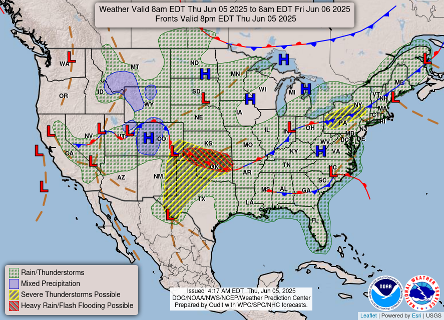
National forecast map for Thursday //Courtesy: National Weather Service
A stationary front is draped across the Gulf Coast, acting as a persistent lifting mechanism. This boundary separates cooler continental air to the north from warm, moist Gulf air to the south. Because the front is not progressing, it serves as a focus for repeated convective initiation. Outflow boundaries from previous storms are also interacting with this front, enhancing localized lift and storm regeneration. The result is training convection, where multiple storm cells move over the same area, leading to excessive rainfall accumulation.
Weak Steering Flow and Upper-Level Support
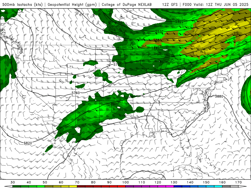
500 mb wind speed, Thursday through Wednesday of next week from the GFS model. //Courtesy: College of DuPage
Upper-level winds are weak and disorganized, particularly in the 500–700 hPa layer. This results in slow-moving or stationary thunderstorms, which prolong rainfall over localized areas. Embedded shortwave troughs and vorticity maxima in the southern stream are periodically enhancing lift, triggering new rounds of convection. The lack of a strong jet stream influence means there’s no mechanism to sweep the moisture or storms out of the region.
Moisture Transport and Thermodynamics
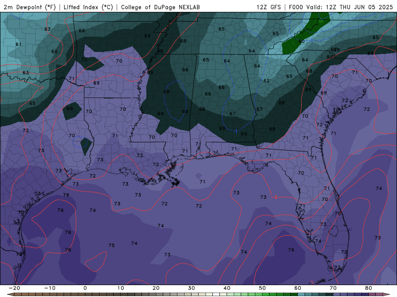
Dew Point Temperatures, Thursday through Wednesday of next week, from the GFS model. //Courtesy: College of DuPage
A deep-layer southerly flow is transporting tropical moisture from the Gulf of Mexico into the region. This is evident in precipitable water (PWAT) values exceeding 2.0 inches, which is 150–200% of normal for early June. These elevated PWAT values indicate a highly saturated atmospheric column, which supports efficient warm-rain processes, meaning storms can produce intense rainfall in a short time. Surface dew points in the mid to upper 70s °F confirm the presence of a moist boundary layer. CAPE values are moderate (1500–2500 J/kg), providing sufficient instability for convective development, especially during peak diurnal heating.
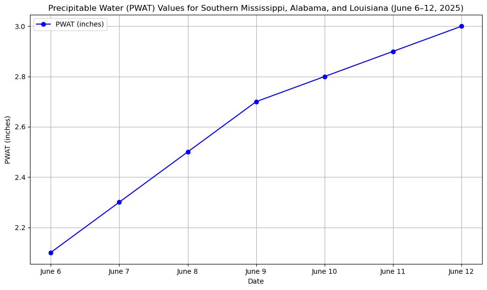
Precipitable Water (PWAT) values chart. //Courtesy: NOAA climatology and model forecasts
PWAT values steadily increase from 2.1 inches to 3.0 inches over the week. These values are well above climatological normal, indicating a very moist atmosphere. This supports the ongoing risk of heavy rainfall and flash flooding, as storms in such a moist environment can produce intense downpours. With antecedent rainfall saturating soils, any additional precipitation leads to rapid runoff. This increases the risk of river flooding as cumulative runoff causes streams and rivers to rise, and flash flooding in urban and low-lying areas.
Regional Day-to-Day Forecast
Tonight – Partly cloudy and warm. Humid conditions persist. The low will be 74°F, winds will be light and variable.
Friday – Mostly sunny with a few afternoon clouds. A stray thunderstorm possible due to lingering moisture. The high will be 88°F with a 20% chance of rain. SW winds at 10-15 mph.
Friday Night: Partly cloudy and warm, the low will be 79°F.
Saturday – Partly sunny with increasing humidity. Isolated thunderstorms are possible in the afternoon. The high will be 90°F, with a 30% chance of rain. Winds SW at 10-20 mph.
Saturday Night – Mostly clear with a few clouds. The low will be 79°F.
Sunday – Intervals of sun and clouds. Afternoon storms may develop, especially inland. The high will be 89°F with a 40% chance of rain. SW winds at 10-15 mph.
Sunday Night – Partly cloudy early, with scattered thunderstorms developing late. The low will be 78°F with a 40% chance of rain.
Monday – Scattered thunderstorms likely, especially in the afternoon. Locally heavy rainfall possible. The high will be 87°F with a 50% chance of rain. SW winds at 10-15 mph.
Monday Night – Continued chance of scattered showers and storms. The low will be 76°F with a 50% chance of rain.
Tuesday – Mostly cloudy with periods of showers and thunderstorms. Rainfall could be heavy at times. The high will be 85°F with a 60% chance of rain. S winds at 10-15 mph.
Tuesday Night – Showers tapering off late. The low will be 75°F with a 40% chance of rain.
Wednesday – Partly sunny with isolated afternoon thunderstorms. The high will be 86°F with a 30% chance of rain. SE winds at 10 mph.
Wednesday Night – Partly cloudy and muggy. The low will be 76°F.
Thursday – Mix of sun and clouds with a few pop-up storms possible. The high will be 87°F with a 30% chance of rain. SE winds at 10-15 mph.
Thursday Night – Mostly clear with patchy clouds. The low will be 75°F.


