General Central/Eastern Kansas Forecast

Short-Term (Friday-Saturday)
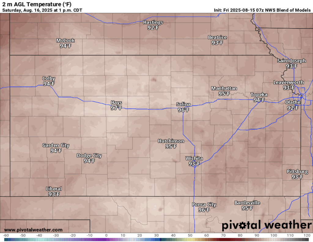
The heat has officially made its return today with high pressure settling in over the region. Today, high temperatures will reach the mid to upper 90s this afternoon, with winds our of the south at 10 to 15 mph, gusting to 30 (mainly for areas north of Salina). Heat indices will be a factor today and tomorrow, with peak values reaching the mid 100s (potentially as high as 107) given relative humidity values of between 45-55%. As such, the National Weather Service has issued a Heat Advisory for all of central and eastern Kansas in effect from 1pm today to 8pm tomorrow. Low temperatures tonight will be on the warmer side, with lows in the upper 70s.
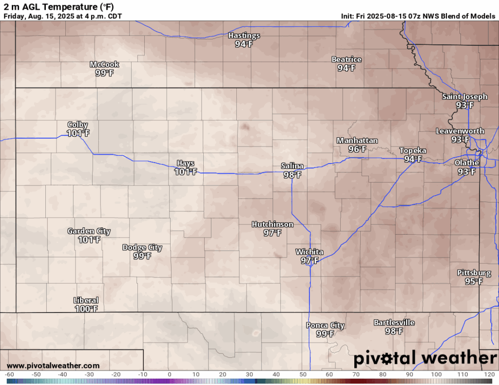

For tomorrow, more hot and dry conditions across the area, with high temperatures expected again to reach the mid to upper 90s. Winds will again be out of the south at 10 to 15 mph, gusting to 25 mph. As previously mentioned, a heat index will still be in effect for tomorrow until 8pm given heat indices in the low to mid 100s. Low temperatures tomorrow night will be similar to tonight, dropping into the upper 70s overnight.
Long-Term (Sunday-Thursday)
Sunday will be more of the same over the past couple of days before some relief may make itself evident by Monday. Some breakdown of the high pressure system over us may allow for some weak disturbances to rotate through and trigger at least some isolated chances for showers and thunderstorms through Wednesday. “Cooler” temperatures will also look to filter in by Wednesday and beyond, as the region of high pressure gets displaced off to the west, which will leave us under a northerly/northwest flow regime that would bring in cooler air and at least daily chances for thunderstorms once again.
Drought Update
Overall drought conditions across central and eastern Kansas remains relatively unchanged last week, with the rain earlier in the week helping to stave off any new development of abnormally dry areas or worsening drought. With the hot and dry weather anticipated over the next few days, some expansion of abnormally dry soil conditions could occur in north-central and southeast Kansas, as this is where soil saturation is currently the driest right now. Future rainfall chances could provide some local relief, but overall, trends would suggest either unchanging soil conditions or at least slightly worsening conditions.


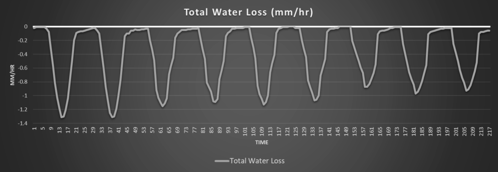
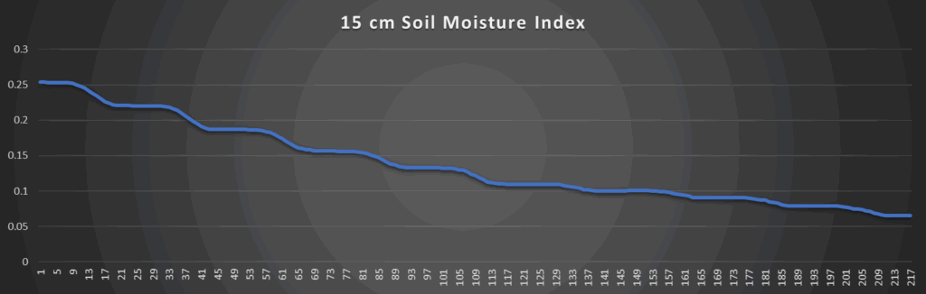
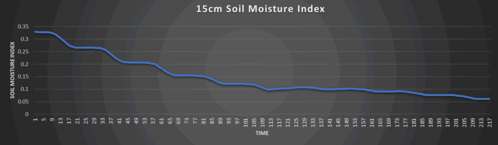
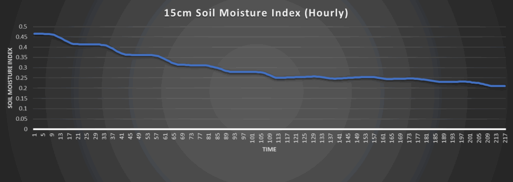
Regional Soil Moisture Outlook
All areas across central and eastern Kansas will steadily dry out over the coming days, especially due to the lack of rainfall and increased heat between the next couple of days. Peak water loss rates will range between 1.4 to 1.7 mm/hr and may begin to pose some soil moisture concerns. Water loss will look to lessen by next week, but a current lack of substantial rain chances in the long-term will either keep soils roughly unchanging to slightly drying out through next week.
Around Westmoreland


Around Scranton


Around Burlington


Around Altoona