The heat wave in the east has intensified, with today being the worst of it. Many locations will crush their record highs, and this could be the hottest day of the summer for many. Severe weather is also a hazard today just east of the Rockies. Tomorrow, a less of a threat covers a larger area into the east. Let’s take a look at all of the details:
Today’s Overall Setup

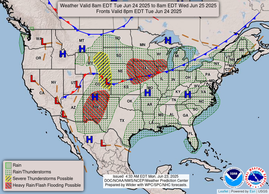

Looking at the 500 mb Height Anomalies, which show the change in the mid-level atmospheric heights versus the average height (orange being higher heights/blue being lower heights), we can see a large area of dark orange, almost red, that is blasting over the midwest, northeast, and parts of the southeast today. Under these high heights is a large ridge of high pressure, that makes it hot and generally drier. Very little amounts of rain are expected in the east today! On the flip side, heavy rain is expected along a cold front to the west and northwest of the ridge in the areas highlighted in red in the surface map. Flash flooding is possible in those regions.
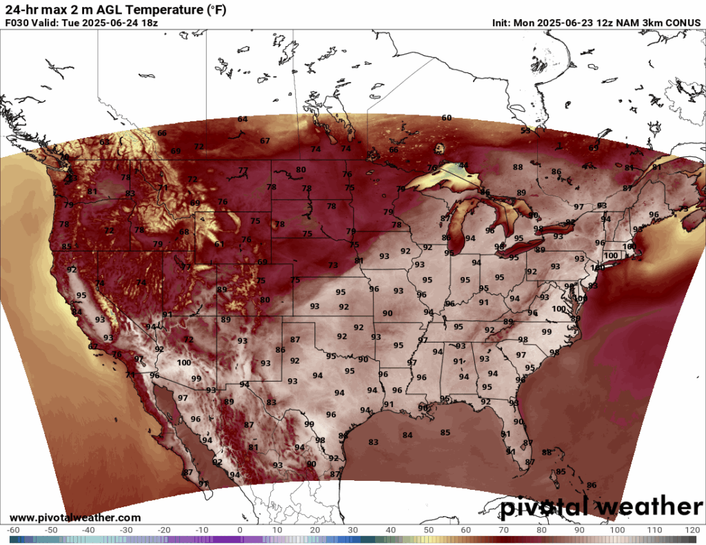
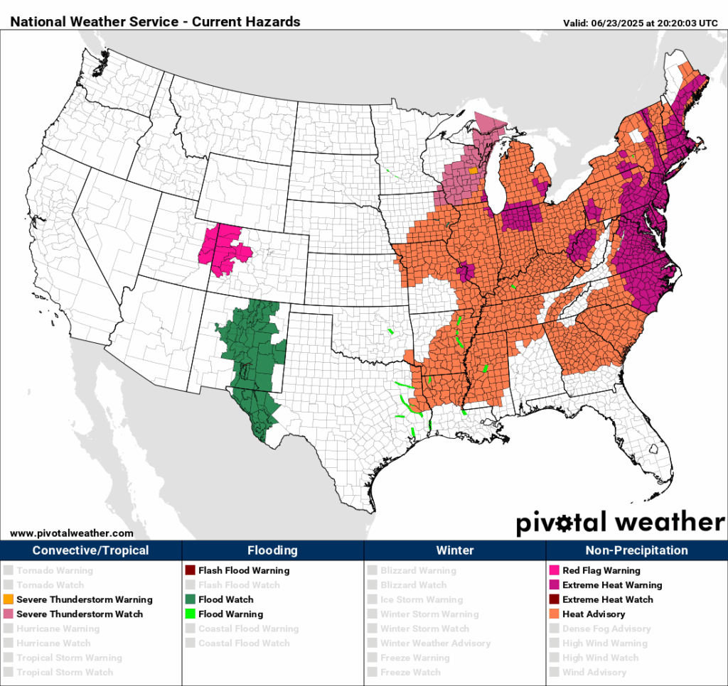
High temperatures for today are soaring up to 100 degrees in NYC, Boston, and most parts of the Mid-Atlantic and northeast. Most areas in the eastern CONUS will experience a high temperature of at least 90 degrees today. Extreme heat warnings and heat advisories are in affect, with heat index’s up to 110 in some areas in the Mid-Atlantic. It is imperative to stay inside in the air conditioning for today and limit any outdoor activity. Stay hydrated throughout the day!
Today’s Severe Weather Threat
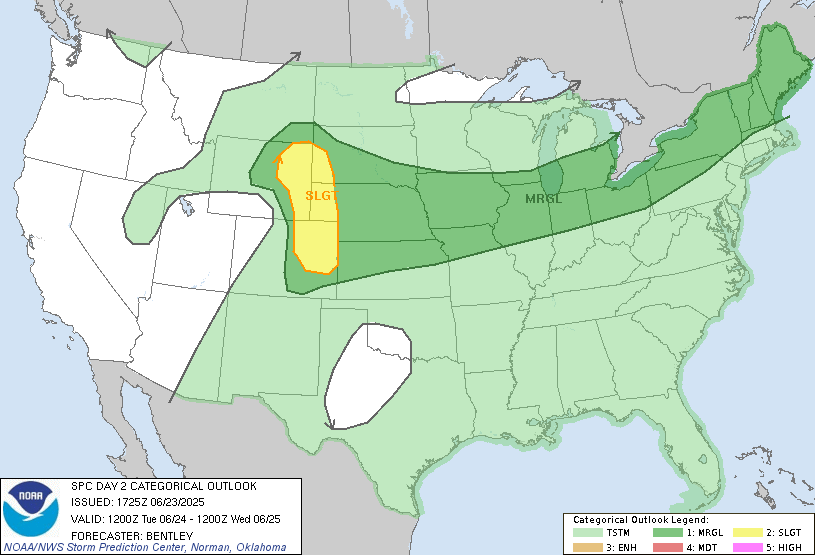
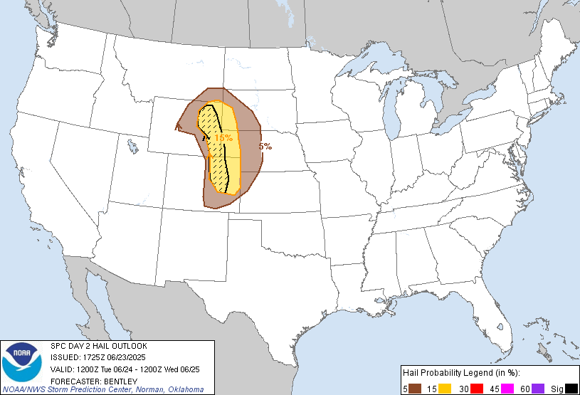
Severe weather is possible today to the west of the monster ridge, where a shortwave trough is in place over Wyoming and Colorado. The main threat in the Slight (2/5) risk zone is for large hail. There is a narrow hatched 15 percent risk of severe hail just east of Denver and northward into northeast Wyoming. This means that there is a 10 percent or greater probability of significant severe hail, specifically hail of 2 inches in diameter or larger. Lot’s of instability is in place for the Marginal (1/5) risk zone, so any popup thunderstorms along the large spanning cold front can turn severe and bring a risk for severe wind gusts, which is the primary hazard in the risk zone.
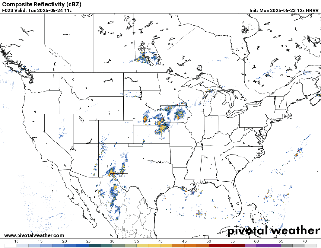
Looking at the high-resolution HRRR modeled composite reflectivity for the severe weather threat today, storms will fire up in the Slight (2/5) risk zone later in the evening, and moves into the midwest, around the flow of the high pressure, into the Marginal (1/5) risk zone into the overnight and into Wednesday morning. Popup severe thunderstorms are possible before the main system comes into the midwest and northeast, so keep an eye out for those cells today.
Wednesday’s Severe Weather Threat

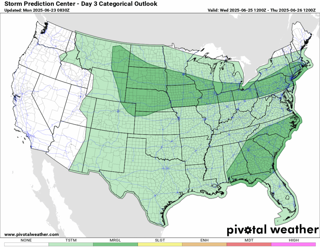
For Wednesday, the weather in the east will be similar to today’s, but with an added Marginal (1/5) risk of severe weather in the southeast and into PA, NJ, CT, and RI. The ridging will be deamplifying and shifting eastward and a stationary front will shift into the northeast, bringing the small chance of severe weather there. A shortwave trough moves through the southeast, which brings the small chance of severe weather there as well.
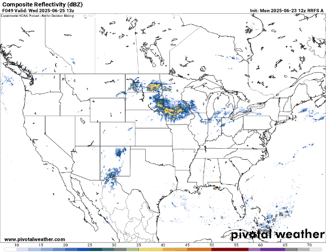
Here is a look at the future composite reflectivity for Wednesday from the RRFS A model. We can see that storms are likely to fire up in the afternoon and could cause torrential downpours and severe wind gusts in the southeast. The northeast could see storms pop up in the late evening and into the overnight hours of Thursday. Heavy thunderstorms and gusty winds are possible there as well. We will keep an eye out on this and report any upgrades from the SPC.
CONUS Weekly Precipitation Outlook
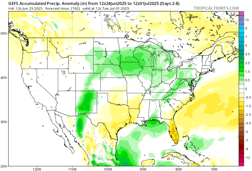
Here’s a look at the GEFS modeled precipitation anomalies through Sunday 12z. Green indicates above average precipitation, white indicates average precipitation, and yellow indicates below average precipitation. Let’s look into the details by region:
Weekly Outlook: Western United States

The desert southwest will trend cooler than average, with an increased amount of troughing expected there over the next week. Lots of rain is expected in New Mexico, with flash floods being a possibility there. Up to 6 inches of rain is expected there over the next week, with most of that falling in a short amount of time. A severe drought is currently in place in New Mexico, so the rain will alleviate the drought – but too much in a short amount of time is not good and can cause flash flooding since the ground is so dry. Moving northward, temperatures in northern California and into the northern Rockies will trend warmer than average and will not see much precipitation at all in the next 7 days.
Weekly Outlook: Central United States

A bunch of systems will pass through the northern plains this week, which will dump a lot of rain into the region – up to 6 inches generally. The southern plains will see less rain, with some parts of Texas seeing none at all!
Weekly Outlook: Eastern United States

After the heat wave passes through, chances of rain go up in the eastern CONUS. Ridging will still be in place, but will not be as intense towards the end of the week. Tropical rain showers and thunderstorms will accumulate 3-5 inches in the gulf coast states.

Temperatures this week in the east, as mentioned before, will be well above average under the heat dome. Summer is in full swing!
Travel Outlook
For those traveling through the slight risk area, key interstates to watch today include I-70, I-76, I-135, and I-80, especially across eastern Colorado, western Kansas, and southern Nebraska. These routes may see the most impact from storms. In the broader marginal risk zone, fewer major interstates are directly affected, but I-35, I-55, I-70, and I-80 still pass through areas where scattered storms could cause delays, especially later in the day.
There’s also a moderate (at least 40 %) chance of flash flooding in central to northern New Mexico, especially around the Sacramento Mountains and burn-scarred areas near Ruidoso, thanks to heavy rain and terrain-driven storms. Stay cautious and do not travel through flooded roadways.
Extended Outlook
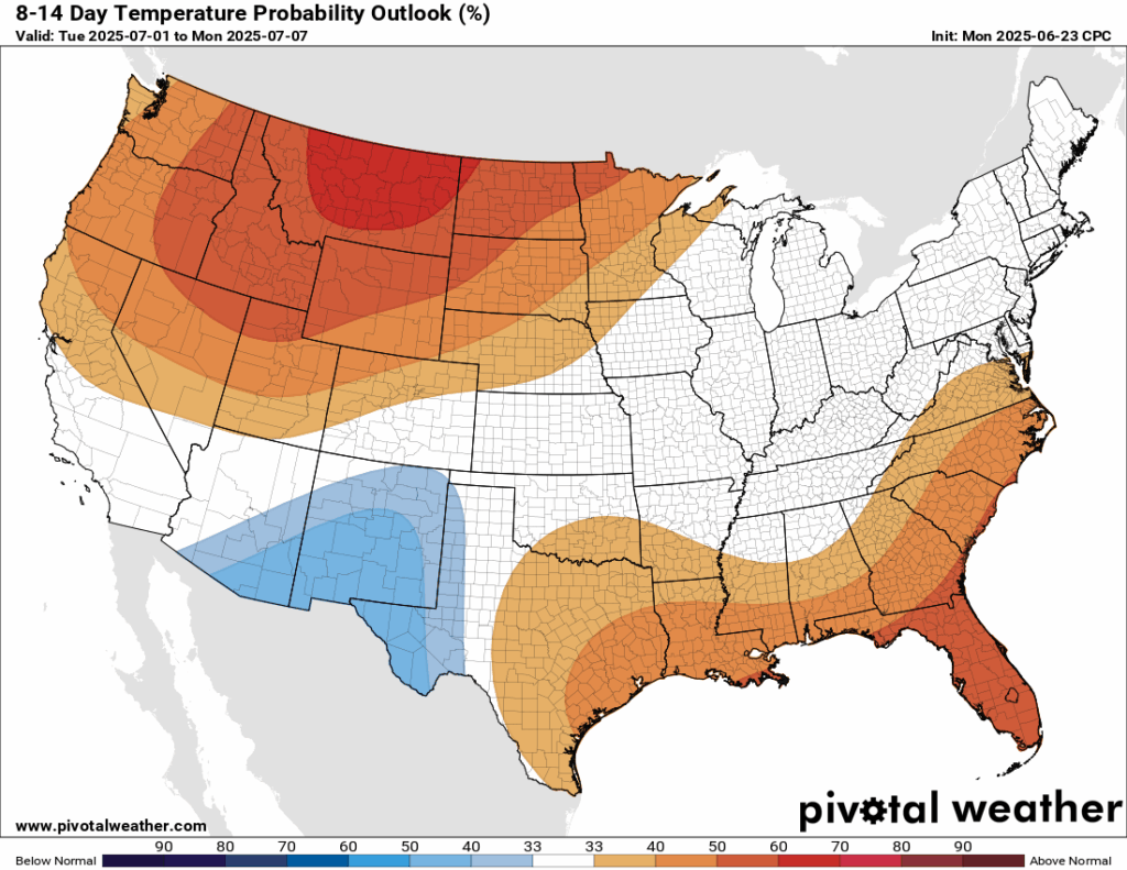
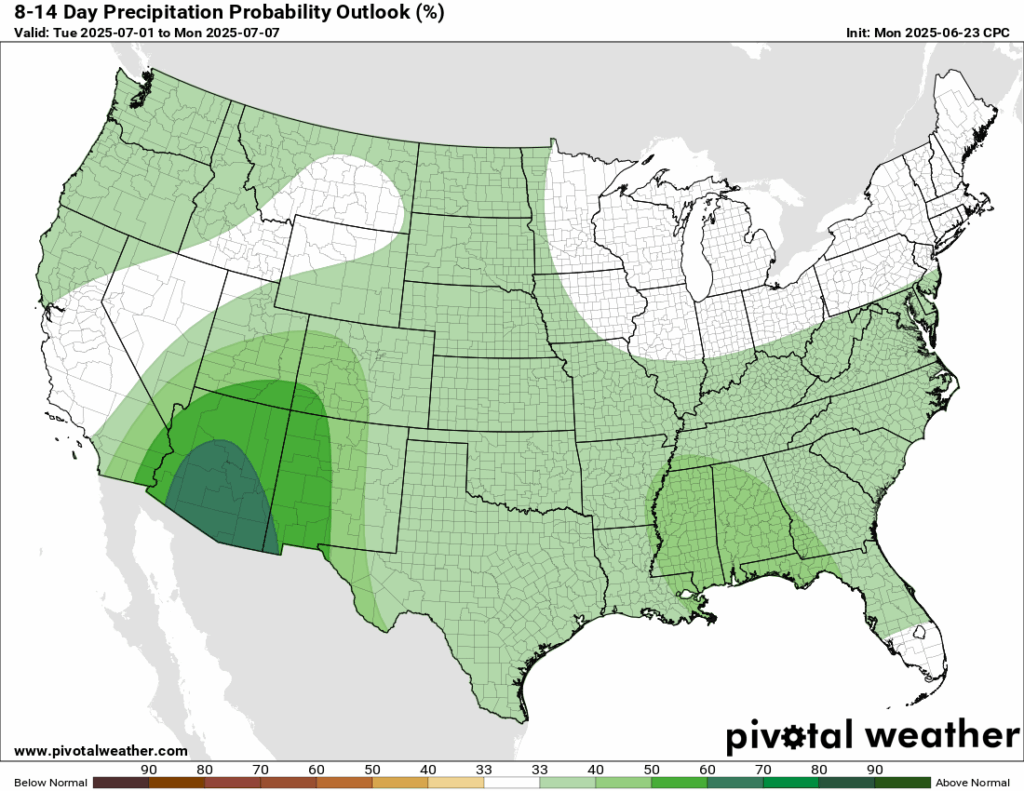
Looking ahead into next week, there is still a chance that the southeast will be above average in terms of temperatures. The northeast and midwest will turn to near-average temperatures, which will feel much better than the current temperatures there. The northern Rockies in the northwest CONUS will likely see above average temperatures, with a big ridge forming in the region by next week. Rainfall in Arizona is expected to be above average next week, which could definetly help the ongoing drought there.
Thanks for tuning in to this National Forecast! Tune in to our local, tropical, and regional forecasts to stay updated on the latest!


