A hot and humid week is unfolding along the Gulf Coast, with daily highs in the low to mid-90s and oppressive dew points pushing heat indices above 105°F. Scattered to numerous afternoon thunderstorms are expected through Saturday, driven by daytime heating, Gulf moisture, and weak upper-level impulses. These storms will be capable of producing frequent lightning, gusty winds, and localized flash flooding, especially in urban areas. A surge of tropical moisture Sunday and Monday will bring widespread, slow-moving storms with heavy rainfall and an increased risk of flash flooding. A weak frontal boundary may enhance storm organization Monday. The unsettled pattern continues into Tuesday with numerous storms, followed by a slight drying trend Wednesday, though isolated to scattered storms and elevated heat stress will persist.
Thursday–Saturday: Hot, Humid, and Storm-Prone Afternoons
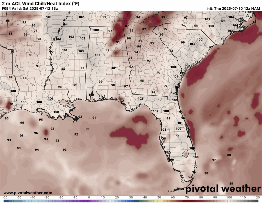
Heat Index for Saturday from the NAM model. //Courtesy: Pivotal Weather
A deep tropical air mass will remain in place through Saturday, keeping dew points in the upper 70s and daytime highs in the low to mid-90s. This combination will push heat indices into the 105–107°F range, creating dangerous heat stress conditions. Each afternoon, scattered to numerous thunderstorms are expected to develop, primarily between 1–7 PM. These will be pulse-type storms, triggered by daytime heating, sea breeze convergence, and weak upper-level impulses. While most storms will be short-lived, they may be intense, producing frequent lightning, torrential downpours of 1–2 inches per hour, and wind gusts up to 40–50 mph. Urban and low-lying areas will be especially vulnerable to localized flash flooding. A slight reduction in storm coverage is possible Friday and Saturday due to weak mid-level ridging, but isolated to scattered storms will still form, particularly inland.
Sunday–Monday: Surge of Tropical Moisture, Widespread Storms
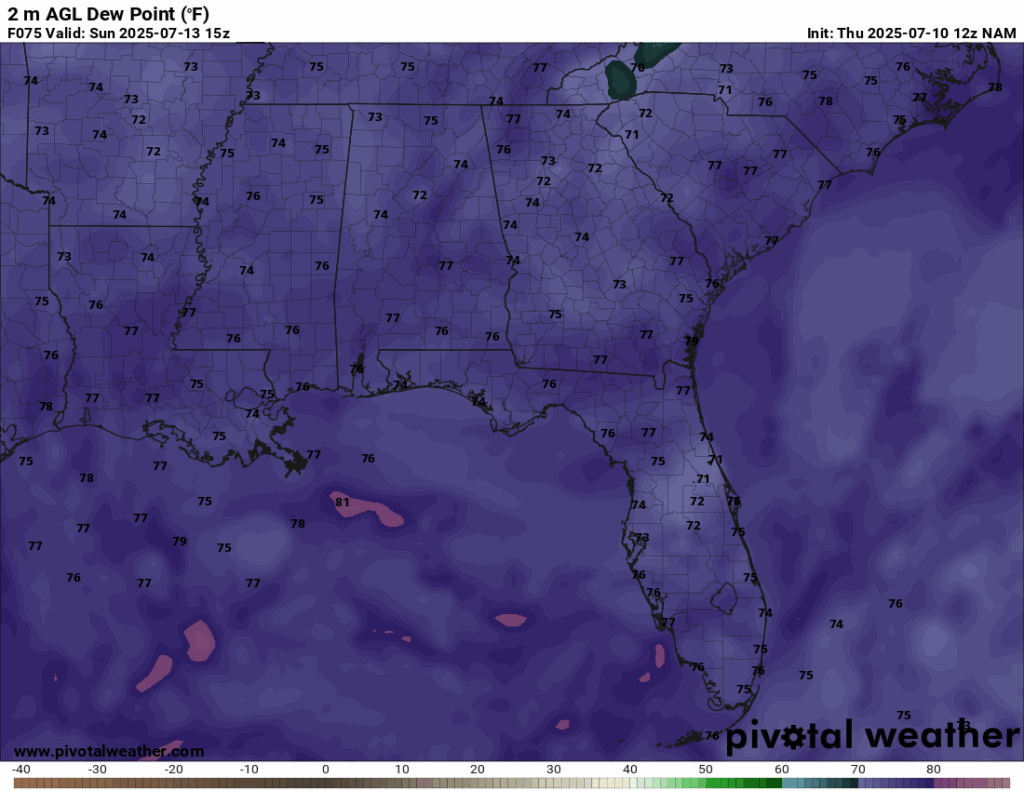
Dew Points for Sunday from the NAM model. //Courtesy: Pivotal Weather
A significant surge of tropical moisture will arrive late Sunday into Monday, bringing precipitable water values above 2.2 inches, indicative of a highly efficient rainfall environment. This will lead to widespread showers and thunderstorms, with activity beginning earlier in the day and continuing into the evening. Storms will likely organize into multicellular clusters, with some training over the same areas. Rainfall totals of 2–4 inches are expected, with locally higher amounts possible. Flash flooding becomes a significant concern, particularly in flood-prone areas and those with poor drainage. A weak frontal boundary approaching from the north on Monday may enhance lift and storm organization, increasing the risk of prolonged heavy rainfall. Frequent lightning and gusty winds will accompany the strongest storms.
Tuesday–Wednesday: Unsettled with Slight Drying Trend
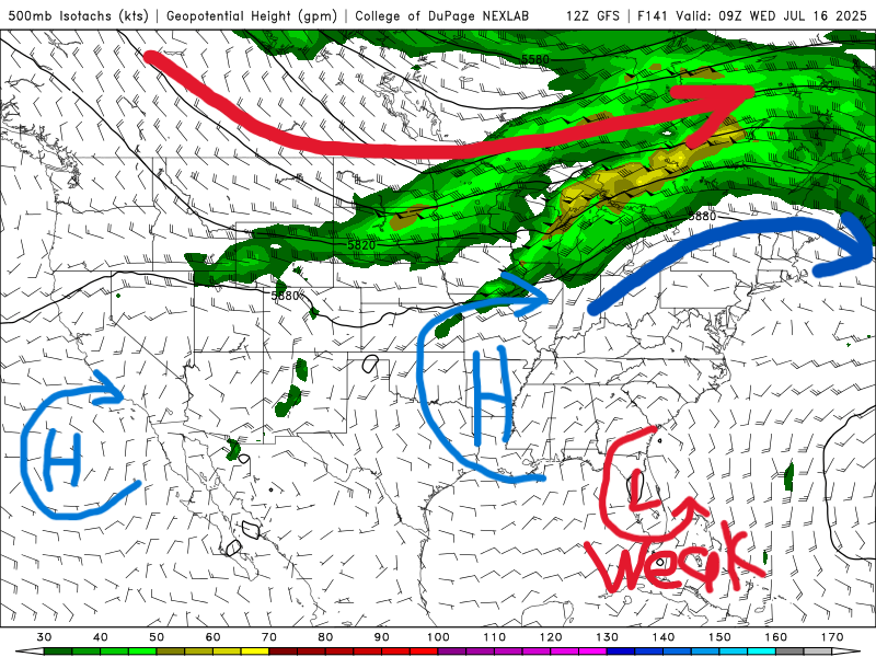
500 mb map for Wednesday of next week from the GFS model. //Courtesy: College of DuPage
The unsettled pattern continues into Tuesday as tropical moisture lingers and a weak frontal boundary remains nearby. Numerous showers and thunderstorms are expected throughout the day, with multiple rounds of rainfall possible. Some storms may be strong, producing gusty winds, heavy downpours, and frequent lightning. By Wednesday, a subtle drying trend aloft may begin to reduce storm coverage slightly, though isolated to scattered storms will still develop, especially along sea breeze fronts. Highs will climb into the low to mid-90s, and with dew points remaining elevated, heat indices will continue to exceed 100°F. While storm coverage may decrease slightly, the combination of heat and humidity will maintain elevated heat stress levels across the region.
Regional Day-to-Day Forecast
Tonight – A 20% chance of showers and thunderstorms. Partly cloudy, with a low around 77°F. West wind around 5 mph.
Thursday – A 50% chance of showers and thunderstorms, mainly in the afternoon. Mostly sunny, with a high near 91°F. Northwest wind 5–10 mph, becoming southwest in the afternoon.
Thursday Night – A 40% chance of showers and thunderstorms, mainly after 10 p.m. Partly cloudy, with a low around 77°F. West wind 5–10 mph.
Friday – Showers and thunderstorms likely, mainly before 1 p.m. Chance of precipitation is 70%. Partly sunny, with a high near 90°F. Northwest wind 5–10 mph, becoming southwest in the afternoon.
Friday Night – A 30% chance of showers and thunderstorms after 1 a.m. Partly cloudy, with a low around 77°F. Southwest wind 5–10 mph.
Saturday – A 50% chance of showers and thunderstorms. Mostly sunny, with a high near 91°F. Southwest wind 5–10 mph.
Saturday Night – A 20% chance of showers and thunderstorms after 1 a.m. Mostly clear, with a low around 77°F. Southwest wind around 5 mph.
Sunday – A 50% chance of showers and thunderstorms. Mostly sunny, with a high near 92°F. West wind 5–10 mph, becoming southwest in the afternoon.
Sunday Night – A 20% chance of showers and thunderstorms after 1 a.m. Partly cloudy, with a low around 77°F. Southwest wind around 5 mph.
Monday – A 50% chance of showers and thunderstorms. Mostly sunny, with a high near 92°F. Southwest wind 5–10 mph.
Monday Night – A 40% chance of showers and thunderstorms. Partly cloudy, with a low around 77°F.
Tuesday – Showers and thunderstorms likely. Chance of precipitation is 60%. Partly sunny, with a high near 93°F.
Tuesday Night – A 30% chance of showers and thunderstorms. Partly cloudy, with a low around 77°F.
Wednesday – A 40% chance of showers and thunderstorms. Mostly sunny, with a high near 92°F.
Wednesday Night – A 20% chance of showers and thunderstorms before midnight. Mostly clear, with a low around 76°F.


