Author: Nick Lilja
|| Published: 8/17/2020 at 11:22am
Fifty-one years ago a Category Five hurricane moved ashore along the Mississippi coast and changed thousands of lives forever. But the story of Camille didn’t stop at the coast. The storm moved through parts of the south and through the Tennessee River Valley and past the Virginias – spreading destruction the entire way.
I wanted to collect a few stories from a a few colleagues to share with everyone. A short anthology of Camille, in a sense.
Hurricane Camille, a review
Living through Camille, with Rex Thompson
Flooding in the Virginias
A Lady Named Camille
A documentary about the storm is available on youtube.
When Havoc Struck
Another documentary available on youtube
Camille Reanalysis
A paper titled, “A Reanalysis of Hurricane Camille” was published in the Bulletin of the American Meteorological Society Volume 97, Issue 3 back in March 2016. The authors, Margaret E. Kieper, Christopher W. Landsea, and John L. Beven, II looked back at the storm.
This is a review of that article by Emily Riter, a former intern.
This article begins by introducing the 50 year old hurricane that began an era of many large scale hurricane’s that would sweep into the Gulf Coast. Hurricane Camille remains as one of the most fascinating hurricanes to ever make landfall in the United States because of its unique records and atmospheric conditions. As a spawn of an African easterly wave, Hurricane Camille traveled into the Caribbean before developing itself into a tropical storm.
Courtesy: Bulletin of the American Meteorological Society
Camille eventually reached a category 5 rating in her lifespan. The most devastating impact to first reach the Gulf Coast was a massive storm surge.,(The power of this storm surge was only surpassed when Katrina hit the coast). The author establishes that the need for reassessment comes from new database development and collection of shortcomings or errors of previous storms. It is then outlined why meteorologists have been weary about the values from Camille’s initial data retrieval. Scientists look at the landfall intensity, maximum wind speeds, and surface pressure.
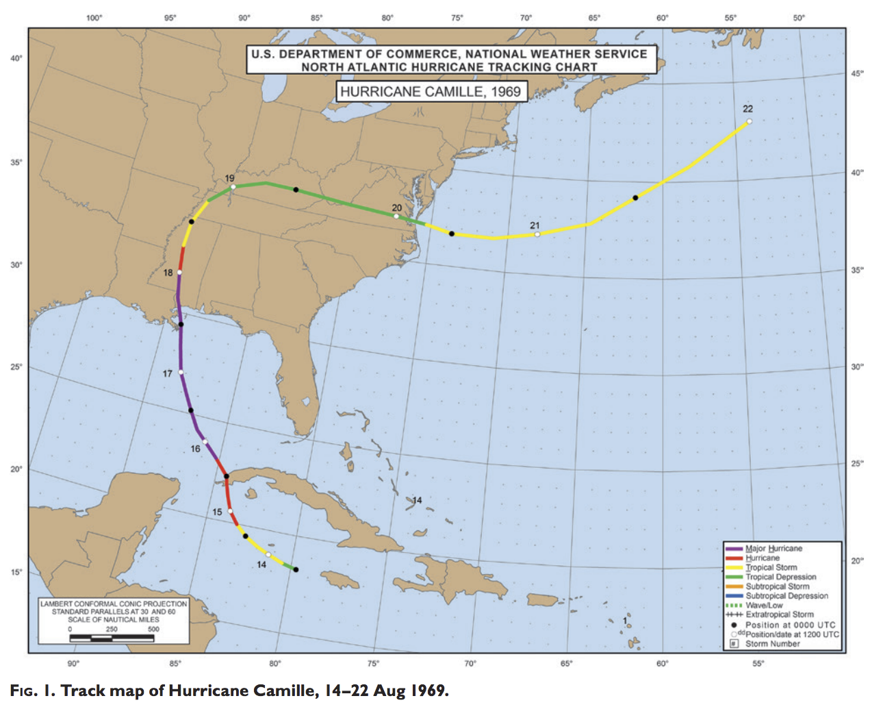
For those who aren’t familiar with Hurricane Camille, her track begins in the Caribbean, moving to the western edge of Cuba, and up through the Mississippi Delta near Bay St. Louis, then the storm continued north bound until reaching the western border of Tennessee and then took a right turn through the Virginia’s and moved back out into the Atlantic.
Courtesy: Bulletin of the American Meteorological Society
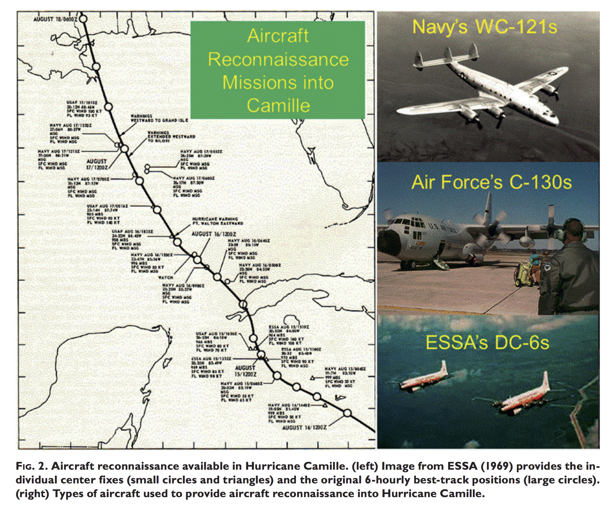
The methodology behind the study is based on the original data findings by means of aviation from both the Navy and Air Force as well as the Environmental Science Services Administration. Upon looking at newer methods of study and newer technology, we can immediately see continuity problems beginning with the genesis imaging from satellite.
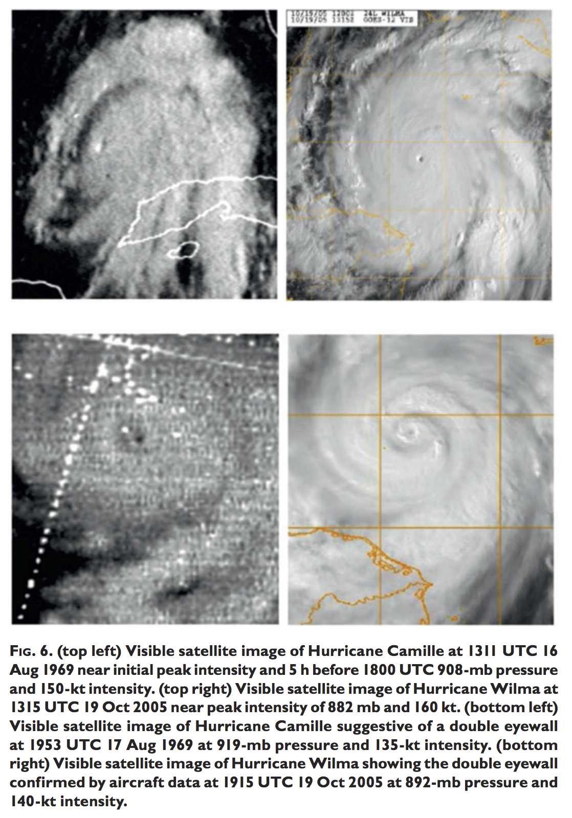
Newer viewing suggests Hurricane Camille actually beginning to organize the bands and cyclonic rotation an entire day earlier than previously expected. With other new discoveries, the author then compares Camille with other Category 5 storms and introduces significant changes that’d been made and implemented into new bases for best-track predictions.
Overall, the author establishes that while it still holds the rating of a 5 on the Saffir-Simpson scale, it is now considered to be the second most intense hurricane to make landfall in the United States. The author claims that the likelihood of seeing another hurricane of this magnitude anytime soon would be unlikely but in the event that we see another, the technology of today would be much more prepared for the event.
Courtesy: Bulletin of the American Meteorological Society
3 Things for Further Study:
What were the water conditions and atmospheric stability readings between West Africa and Jamaica and then what changed as the bands reached the Gulf of Mexico? Was the water in mid August more significant in the Gulf in comparison to off the coast of West Africa?
What was the instrument Mr. Charles Breath used? Why can’t it properly identified today? How was he able to gather readings from the eye of the storm as well as gather data from two different locations.
Which would be more efficient for gathering accurate data? Readings collected from the tools on the ground as the eye moves across and gives readings; or having aviation drop sones or other technology into the storm and collect data in a top down approach with the break-down of the storm to carry the machine and record data?
Modern Meteorology:
With this modern reanalysis of the data from Hurricane Camille, I find that not only will this encourage more reanalysis of other monumental events. More specifically, I think this gives clearer data into where Hurricane Camille actually made landfall and the magnitude of it’s pressure and wind speeds.
Thanks for reading ya’ll! If you would like to read more, the full text can be found here: https://journals.ametsoc.org/doi/pdf/10.1175/BAMS-D-14-00137.1. Another text about Camille can be found here: https://www.coast.noaa.gov/hes/docs/postStorm/H_CAMILLE.pdf. One of two so when you finish with this one, check out my next one for some good evening reading. Goodnight.
Author of the article:
Nick Lilja
Nick is former television meteorologist with stints in Amarillo and Hattiesburg. During his time in Hattiesburg, he was also an adjunct professor at the University of Southern Mississippi. He is a graduate of both Oregon State and Syracuse University that now calls Houston home. Now that he is retired from TV, he runs this site and its app in his spare time.