Yep, the rain is still hanging around and it’ll be a guest that overstays its welcome all this week. The other bad news is that it won’t quite fight off the heat as much as we would like it to. More afternoon thunderstorms are possible throughout the week, but it’ll be in the wake of the already hot temperatures that will hit by early afternoon, so heat indices will be fairly high this week.
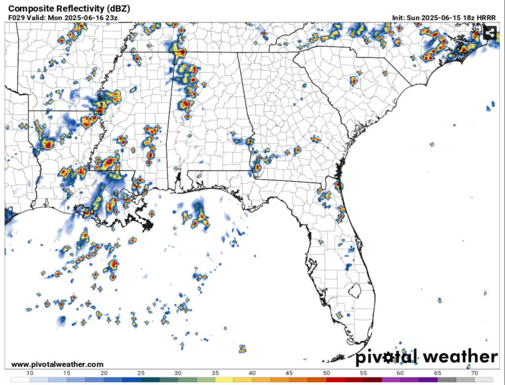
An Atlantic high pressure system is already present and is steadily growing towards the southeast. Since it’s slowly creeping to our region, it will inhibit the surface low pressure systems and push them further northward. However, they will still have an effect on our weather patterns as they form and move towards the Midwest. Most of the rain for the first half of the week will follow a southwestern surface wind and move showers and thunderstorms in from TX/LA coast and move further inland.
Towards the end of the week, the Atlantic high at the surface will move in and a strong ridge at the upper levels will build. This will reduce rain chances by the weekend but also bring the heat back to much of the Southeast. Heat indices will gradually climb from the upper 90s to the low 100s by the weekend, so please keep water, electrolytes, and sunscreen on you if you’re going outside or have limited access to air conditioning. Highs will remain in the low to mid 90s during the day and the low to mid 70s at night.
Bottom line: expect rain and thunderstorms, some strong, in the first half of the week. Heat indices will still be in the upper 90s, so it’ll be hot before the rain moves in. The latter half of the week the rain chances will gradually reduce, but prepare for the miserable heat to come back.
Regional Day-to-Day Forecast
Tonight – A 30 percent chance of showers and thunderstorms, mainly before sunset. Mostly cloudy, then gradually becoming mostly clear, with a low in the low 70s. Calm wind.
Monday – Showers and thunderstorms in the afternoon. High in the low 90s. Heat index values as high as 99. Light south southwest wind becoming southwest 5 to 10 mph in the morning. Chance of precipitation is 80%. New rainfall amounts between a tenth and quarter of an inch, except higher amounts possible in thunderstorms.
Monday Night – Showers and thunderstorms likely, mainly before sunset. Partly cloudy, with a low in the low 70s. South wind around 5 mph becoming calm in the evening. Chance of precipitation is 60%. New precipitation amounts of less than a tenth of an inch, except higher amounts possible in thunderstorms.
Tuesday – Showers and thunderstorms in the afternoon. High in the low 90s. Heat index values as high as 102. Calm wind becoming southwest around 5 mph in the morning. Chance of precipitation is 80%. New rainfall amounts between a quarter and half of an inch possible.
Tuesday Night – Partly cloudy, with a low in the low to mid 70s. South wind around 5 mph becoming calm in the evening.
Wednesday – Showers and thunderstorms likely in the afternoon. Mostly sunny, with a high in the low 90s. Calm wind becoming south around 5 mph in the morning. Chance of precipitation is 70%. New rainfall amounts between a tenth and quarter of an inch, except higher amounts possible in thunderstorms.
Wednesday Night – Partly cloudy, with a low in the low to mid 70s. South wind around 5 mph becoming calm in the evening.
Juneteenth – Showers and thunderstorms likely in the afternoon. Mostly sunny, with a high in the low to mid 90s. Calm wind becoming west southwest around 5 mph in the afternoon. Chance of precipitation is 60%.
Thursday Night – A 20 percent chance of showers and thunderstorms before midnight. Partly cloudy, with a low in the low to mid 70s. Southwest wind around 5 mph becoming calm.
Friday – Showers and thunderstorms likely, mainly in the afternoon. Mostly sunny, with a high in the low to mid 90s. Chance of precipitation is 60%.
Friday Night – A 20 percent chance of showers and thunderstorms. Mostly clear, with a low in the low to mid 70s.
Saturday – A 50 percent chance of showers and thunderstorms. Sunny, with a high in the mid 90s.
Saturday Night – Mostly clear, with a low in the low to mid 70s.
Sunday – A 50 percent chance of showers and thunderstorms. Sunny, with a high in the mid 90s.


