Building a local forecast has morphed over the last few years as we have grown and introduced our app. While people still want the super specific information about how the weather will impact them, they also want an added explanation about how the weather is developing every day so they can plan appropriately.
Here are the steps to making a solid local forecast that will help your audience understand the forecast…
WHERE ARE WE FORECASTING?
Generally, we forecast for the counties highlighted in green, red and blue on the map below.
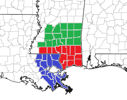
At times, we may include some of the counties in Alabama, but we usually only mention them in passing day-to-day and only highlight them during high impact weather events.
STRUCTURING A FORECAST
Building a forecast has 5 + 1 parts. Five parts for the discussion and one part for the day-to-day rundown. Here is how it breaks down:
- Introduction: The first paragraph sets the tone for the forecast by stating what is the most important thing happening in the weather during the next few days.
- Example: “While we enjoy sunshine for the next few days, do know that the potential for afternoon storms exists nearly every day, so keep an eye to the sky while you’re out and about. So far it doesn’t look like a complete washout, on any one day, but if you get caught out in the rain unprepared, you’ll have a chance to get soaked. Let’s take a look at what is going on.”
- Description of the Situation: The second (and perhaps third and fourth) paragraph should build on the first diving into what is happening in the atmosphere to lead to the conditions that will be apart of the main concern during the next few days and what to expect from those conditions.
- Example: “Our friend the subtropical ridge in the eastern Gulf is throwing moisture our direction and it’ll be around for the next few days. With a southerly wind off the Gulf we will have the seabreeze every day with afternoon storms. So even though there is no cold front moving our direction, there is still a chance for rain nearly every day.
This subtropical ridge is running about two standard deviations above the mean, too! It is stout! That means a few things. First, it will be stubborn to move for the next few days. Second, it will help to keep anything in the tropics away from the area by blocking any incoming tropical waves, storms or hurricanes. And, perhaps most importantly, this also means higher humidity and feels like temperatures around 100F.
If you have outdoor plans make sure you get plenty of water and try and find some shade – when you can – if you’re going to be doing yard work or running around with the kids. And, as mentioned, keep an eye to the horizon looking for nearby storms and keep an ear out for thunder. And, as the National Weather Service says, ‘when thunder roars, head indoors’ so you can avoid being struck by lightning.
This pattern will eventually shift and shut down the storms, but then highs approaching 100F and feel like temperatures around 110F will be possible – but more on that in a minute.”
- Example: “Our friend the subtropical ridge in the eastern Gulf is throwing moisture our direction and it’ll be around for the next few days. With a southerly wind off the Gulf we will have the seabreeze every day with afternoon storms. So even though there is no cold front moving our direction, there is still a chance for rain nearly every day.
- Cover the Concerns: The next few paragraphs should highlight the chief concerns related to the weather during the next few days if not explicitly mentioned above. Reiterating weather hazards is never a bad thing. I’ll say it again! Reiterating weather hazards is never a bad thing. And you can do it without sounding like you are repeating yourself, too.
- Example: “Before we get to the big heat, it’s the afternoon storms we are worried about. These storms may pack some brief heavy rain, frequent lightning, gusty wind, and perhaps small hail. The tornado threat is quite low, but not completely zero. As we have seen the last few summers, brief and weak tornadoes can occur along storms that develop at intersecting outflow boundaries.
Aside from the storms, the humidity-driven heat is our other concern. The afternoon highs might only be in the 90s, but it will feel like around 100F. So water will be essential if outside.”
- Example: “Before we get to the big heat, it’s the afternoon storms we are worried about. These storms may pack some brief heavy rain, frequent lightning, gusty wind, and perhaps small hail. The tornado threat is quite low, but not completely zero. As we have seen the last few summers, brief and weak tornadoes can occur along storms that develop at intersecting outflow boundaries.
- Extended Outlook: The next set of paragraphs should cover the expected weather conditions beyond Day 5 for people making plans for next week.
- Example: “As this pattern shifts and the ridging tries to move to our northwest, we get into a more northerly flow which should ease back on the humidity a touch, but temperatures will easily climb to around 100F with Feels Like temperatures around 110F.
The other concern when ridging moves back to our northwest is that it opens up the Gulf of Mexico for business with respect to tropical riff-raff. This means we will have to monitor tropical waves closer as we move through next week. So if you are planning a trip to the beach or even just a road trip with the family, please keep tabs on the forecast.”
- Example: “As this pattern shifts and the ridging tries to move to our northwest, we get into a more northerly flow which should ease back on the humidity a touch, but temperatures will easily climb to around 100F with Feels Like temperatures around 110F.
- Maps/Graphics/Charts/Multimedia: Make sure to include a few graphics in your post, too. And reference these while writing so people can get a good idea about what is happening. This is especially important when talking about the “Ts” – temperatures, timelines, and threats.
- Examples:
- “Take a look at the animation above, this shows storms moving through the area during the afternoon.”
- “Take a look at the temperature map, plenty of 80s and 90s on there.”
- “Take a look at the timeline chart, the best bet for rain is between 5p and 8p. Then a few lingering storms overnight.”
- Examples:
- Regional Day-to-Day Forecast: The remaining portion of the forecast presents a day-to-day forecast, generalized for the area, including high and low temperatures, wind directions, and chances of rain for each day for the next 10 days.
- Example:
- Today: Sunny. A chance of showers and thunderstorms this afternoon. Highs in the mid 90s. Northwest winds 5 to 10 mph. Chance of rain 30 percent.
Tonight: Mostly clear. A slight chance of showers and thunderstorms in the evening. Lows in the upper 60s. West winds 5 to 10 mph. Chance of rain 20 percent.
Friday: Sunny. A chance of showers and thunderstorms in the afternoon. Highs in the lower 90s. North winds 5 to 10 mph. Chance of rain 40 percent.
- Today: Sunny. A chance of showers and thunderstorms this afternoon. Highs in the mid 90s. Northwest winds 5 to 10 mph. Chance of rain 30 percent.
- Example:
Now let’s put it all together!
While we enjoy sunshine for the next few days, do know that the potential for afternoon storms exists nearly every day, so keep an eye to the sky while you’re out and about. So far it doesn’t look like a complete washout, on any one day, but if you get caught out in the rain unprepared, you’ll have a chance to get soaked. Let’s take a look at what is going on.
Our friend the subtropical ridge in the eastern Gulf is throwing moisture our direction and it’ll be around for the next few days. With a southerly wind off the Gulf we will have the seabreeze every day with afternoon storms. So even though there is no cold front moving our direction, there is still a chance for rain nearly every day.
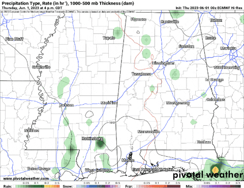
Take a look at the animation above, this shows storms moving through the area during the afternoon.
This subtropical ridge is running about two standard deviations above the mean, too! It is stout! That means a few things. First, it will be stubborn to move for the next few days. Second, it will help to keep anything in the tropics away from the area by blocking any incoming tropical waves, storms or hurricanes. And, perhaps most importantly, this also means higher humidity and feels like temperatures around 100F.
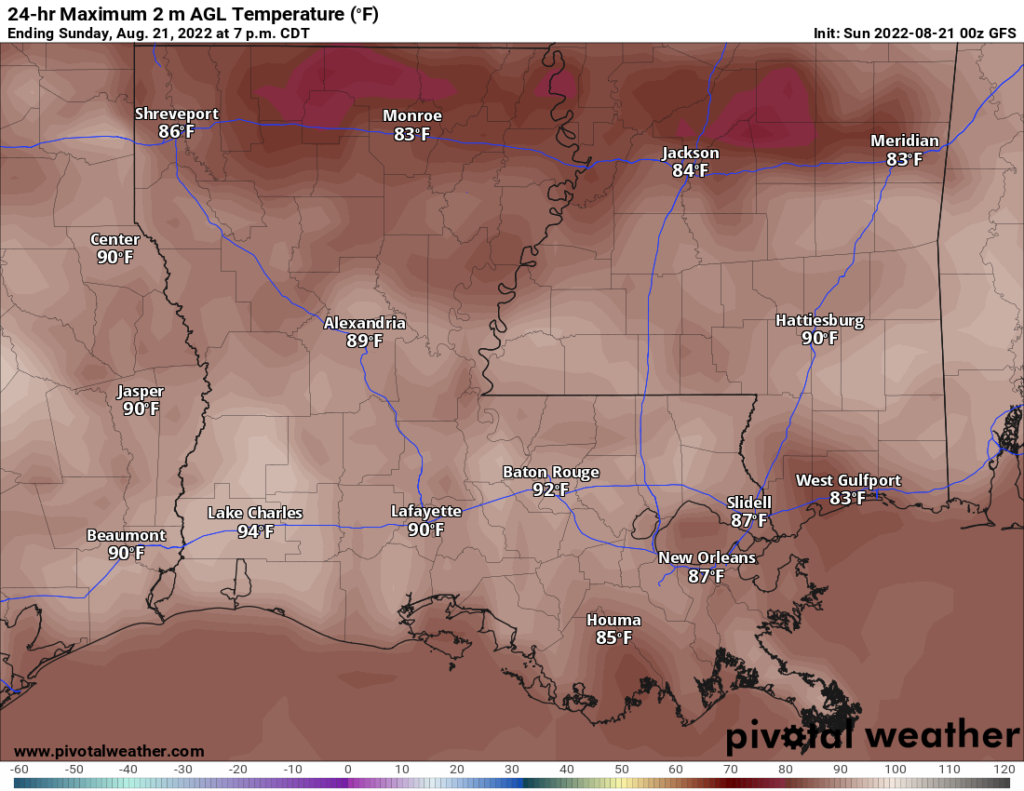
Take a look at the temperature map, plenty of 80s and 90s on there.
If you have outdoor plans make sure you get plenty of water and try and find some shade – when you can – if you’re going to be doing yard work or running around with the kids. And, as mentioned, keep an eye to the horizon looking for nearby storms and keep an ear out for thunder. And, as the National Weather Service says, ‘when thunder roars, head indoors’ so you can avoid being struck by lightning.
This pattern will eventually shift and shut down the storms, but then highs approaching 100F and feel like temperatures around 110F will be possible – but more on that in a minute.
Before we get to the big heat, it’s the afternoon storms we are worried about. These storms may pack some brief heavy rain, frequent lightning, gusty wind, and perhaps small hail. The tornado threat is quite low, but not completely zero. As we have seen the last few summers, brief and weak tornadoes can occur along storms that develop at intersecting outflow boundaries.
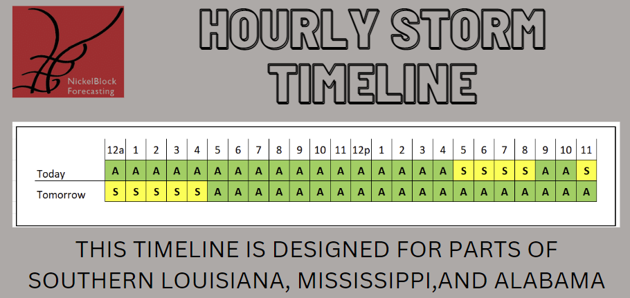
Take a look at the timeline chart, the best bet for rain is between 5p and 8p. Then a chance overnight, too.
Aside from the storms, the humidity-driven heat is our other concern. The afternoon highs might only be in the 90s, but it will feel like around 100F. So water will be essential if outside.
As this pattern shifts and the ridging tries to move to our northwest, we get into a more northerly flow which should ease back on the humidity a touch, but temperatures will easily climb to around 100F with Feels Like temperatures around 110F.
The other concern when ridging moves back to our northwest is that it opens up the Gulf of Mexico for business with respect to tropical riff-raff. This means we will have to monitor tropical waves closer as we move through next week. So if you are planning a trip to the beach or even just a road trip with the family, please keep tabs on the forecast.
REGIONAL DAY TO DAY FORECAST
Today: Sunny. A chance of showers and thunderstorms this afternoon. Highs in the mid 90s. Northwest winds 5 to 10 mph. Chance of rain 30 percent.
Tonight: Mostly clear. A slight chance of showers and thunderstorms in the evening. Lows in the upper 60s. West winds 5 to 10 mph. Chance of rain 20 percent.
Friday: Sunny. A chance of showers and thunderstorms in the afternoon. Highs in the lower 90s. North winds 5 to 10 mph. Chance of rain 40 percent.
Friday Night: Partly cloudy in the evening, then clearing. Lows in the upper 60s. Northeast winds 5 to 10 mph.
Saturday: Mostly sunny. A chance of showers and thunderstorms in the afternoon. Highs in the lower 90s. East winds around 5 mph, becoming southwest in the afternoon. Chance of rain 40 percent.
Saturday Night: Mostly cloudy Lows in the upper 60s.
Sunday: Sunny. A few storms possible. Highs in the lower 90s. Chance of rain 40 percent.
Sunday Night: Mostly clear. Lows in the lower 70s.
Monday: Mostly sunny. A few storms possible. Highs in the lower 90s. Chance of rain 30 percent.
Monday Night: Mostly clear. Lows in the upper 60s.
Tuesday: Sunny. A slight chance of showers and thunderstorms in the afternoon. Highs in the lower 90s. Chance of rain 20 percent.
Tuesday Night: Mostly clear in the evening, then becoming partly cloudy. Lows in the lower 70s.
Wednesday: Sunny. Highs in the mid 90s.
Next Thursday: Sunny. A chance of showers and thunderstorms this afternoon. Highs in the mid 90s. Northwest winds 5 to 10 mph. Chance of rain 30 percent.
Next Thursday night: Mostly clear. A slight chance of showers and thunderstorms in the evening. Lows in the upper 60s. West winds 5 to 10 mph. Chance of rain 20 percent.
Next Friday: Sunny. A chance of showers and thunderstorms in the afternoon. Highs in the lower 90s. North winds 5 to 10 mph. Chance of rain 40 percent.
Next Friday Night: Partly cloudy in the evening, then clearing. Lows in the upper 60s. Northeast winds 5 to 10 mph.
Next Saturday: Mostly sunny. A chance of showers and thunderstorms in the afternoon. Highs in the lower 90s. East winds around 5 mph, becoming southwest in the afternoon. Chance of rain 40 percent.
Not bad!
Now you’ve successfully created your first Local Forecast Post! If you have any questions make sure to reach out to Nick or Noah!

