A Quick Note…
Hey everyone! After a two-year hiatus, the Kansas Agriculture Forecasts will be making a comeback, but instead of weekly updates, I plan on trying to do daily updates (tentatively) 5 days a week. These will be somewhat similar in format to how they were done a couple of years ago, but I will be tinkering with it and potentially making some changes as time goes along. With that said, it is good to be able to put these out again, and I hope you all enjoy these forecasts! – Kaden Schroeder
General Central/Eastern Kansas Forecast
Short-Term (Tuesday and Wednesday)
Rain chances will taper off across much of central/eastern Kansas Tuesday as main disturbance aloft that has triggered the last couple days of rain lifts off towards the east. Widespread cloud cover will stick around and keep our temperatures down in the mid 60s throughout the day. Low temperatures Tuesday night will be quite cool for late May, bottoming out in the low/mid 50s, although isolated pockets of upper 40s near the Kansas-Nebraska border cannot be ruled out. Wednesday looks to remain fairly dry, as we get some high pressure trying to build in over the state behind this departing system. Temperatures will rise into the mid/upper 60s as the clouds try to break.

Projected hourly temperatures from Tuesday morning to Thursday morning // Courtesy: Pivotal Weather
Long-Term (Thursday-Saturday)
By Thursday, rain chances will return to the region as another shortwave impinges on the area. No severe activity is expected with this round of storms, although heavier rainfall may be possible, especially further south and west towards the Wichita area. New rainfall totals may approach 1″ with this system, while the rest of the area will remain between 0.01 inches to 0.5 inches. Temperatures on Thursday will climb into the upper 60s to low 70s, before falling back to the mid 50s overnight. Friday will see rain chances become more sporadic as the shortwave moves off to the southeast. Otherwise, largely drier conditions will be in play, with temperatures rising into the upper 70s during the day and falling to the upper 50s at night. By Saturday, another potential disturbance from the north may come through and increase chances for showers and thunderstorms across the region once more.
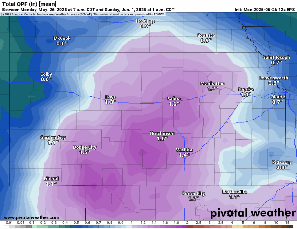
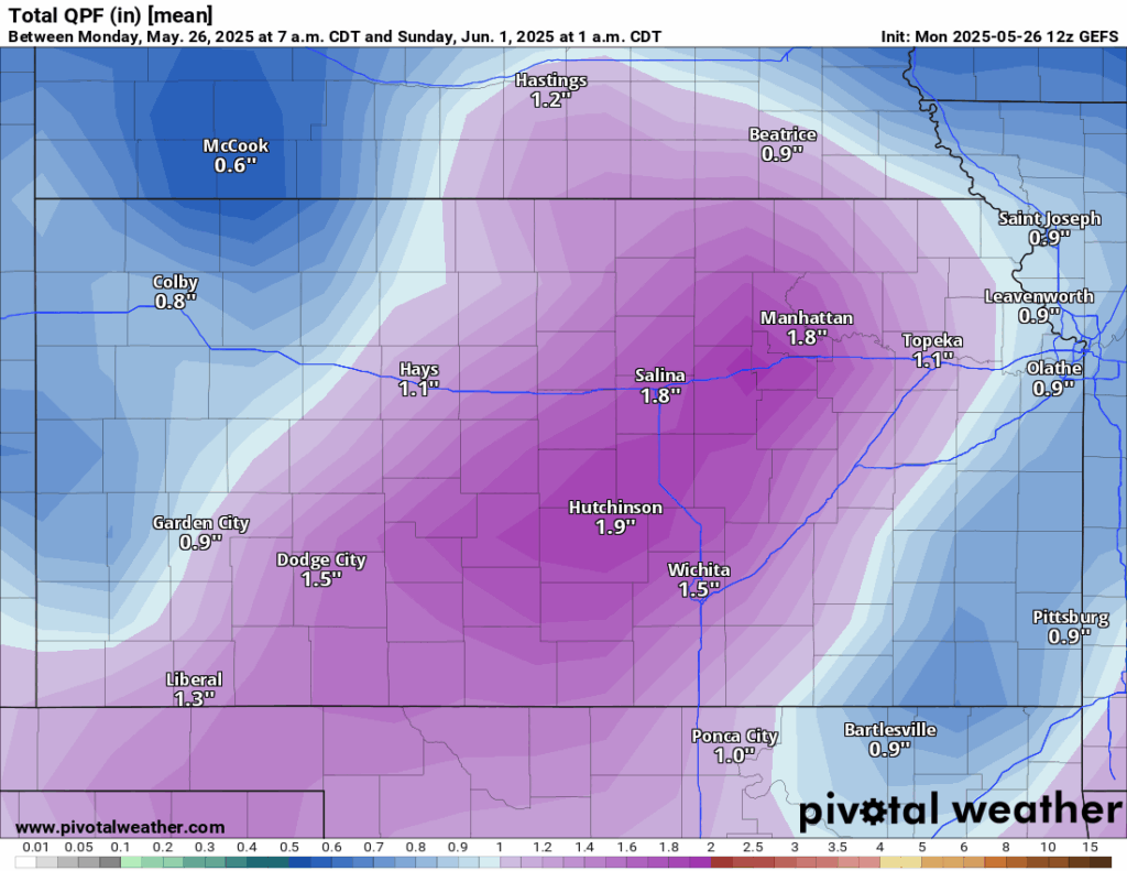

Projected Total Rainfall through Saturday from the Euro ensembles (top left), NBM (bottom), and GFS ensembles (top right). // Courtesy: Pivotal Weather
Soil Moisture Outlook
Soils look to remain largely saturated across central and eastern Kansas due to the recent round of rains over the past couple of days. The majority of the area will continue to see 10-15cm soil moisture saturation between 70-90% over the next 5 days due to the rainfall and limited drying due to cloud cover and evapotranspiration loss. Areas across northern and north central Kansas may remain lower near the 50-60% mark as most of the rain has not impacted here as much as for areas to the south.


