General Central/Eastern Kansas Forecast
Short-Term (Wednesday-Friday)
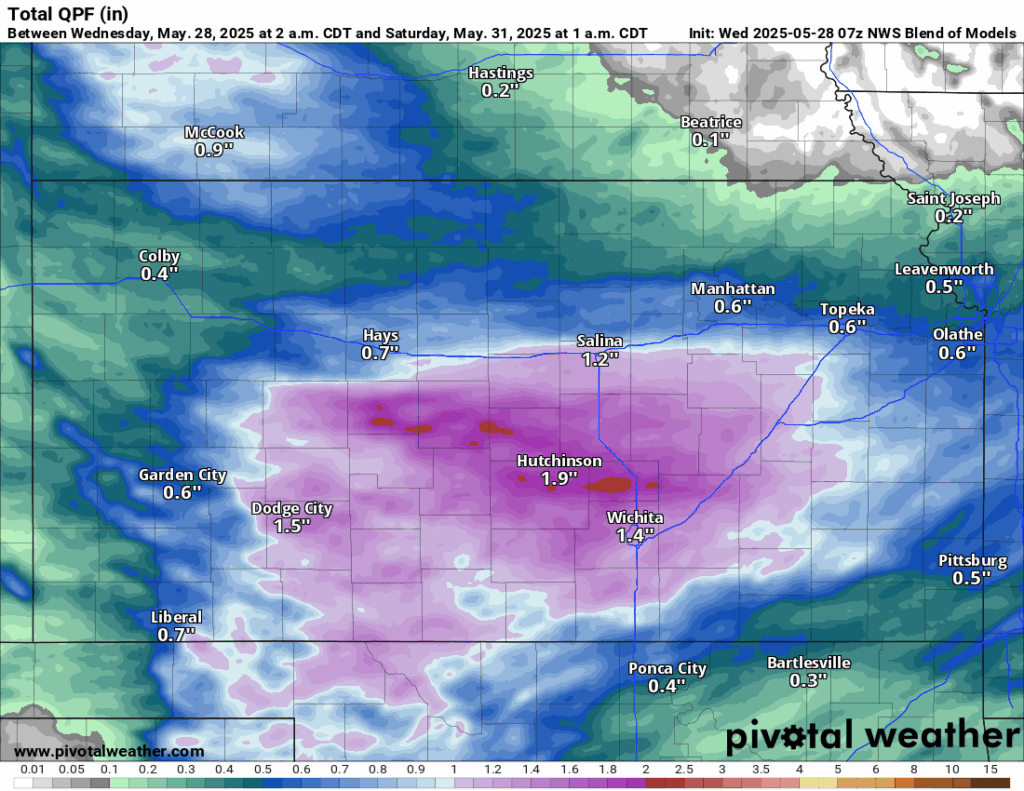
Rain chances will increase once again throughout the area Wednesday afternoon and evening as another small-scale disturbance passes through the state and provides enough lift for the development of scattered rain showers. Widespread heavy rainfall is not anticipated, although localized pockets of moderately heavy showers may be possible. New rainfall totals from this round of showers may reach 0.5 to 1 inch, with possible amounts approaching 1.5 inches possible closer to the I-135 corridor. Otherwise, high temperatures area wide will be in the mid/upper 60s, with low 70s possible south and east of I-35. Overnight, low temperatures will dip down into the low/mid 50s, with isolated pockets of upper 40s possible in north central Kansas near the Nebraska border. Rain will continue into Thursday morning before tapering off by the afternoon as the system moves off to the southeast. By Friday, a drying period will finally set in as high pressure builds over the region and keeps us free of any rain showers. Temperatures will begin to climb during this period as well, with high temperatures reaching the upper 60s/low 70s by Thursday and upper 70s by Friday. Low temperatures will also be steadily increasing from the low 50s Thursday night/Friday morning to the mid/upper 50s Friday night/Saturday morning.
Long-Term (Saturday-Tuesday)
Heading into the weekend, another quick disturbance will come in from the north Saturday afternoon, but rain chances at this time are low due to relatively drier conditions aloft. Otherwise, temperatures will continue their steady climb into the low 80s during the day. This warming trend will persist into Sunday and Monday, with temperatures reaching the low/mid 80s by Monday and continuing on into early next week. Rain chances during this period will continue to be negligible as high pressure continues to build.
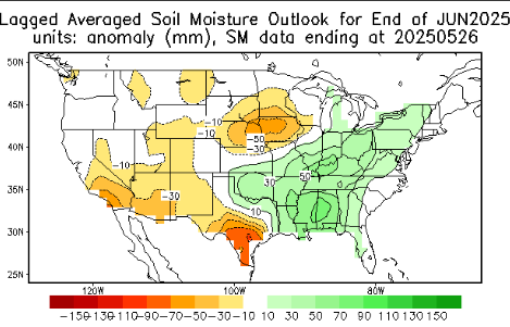
Soil Moisture Update
Soil conditions remain very saturated throughout central and eastern Kansas due to the recent rains (70-90% saturated from 5-50cm). Expectations are for soils to remain fairly wet through the short-term period before some drying occurs as we encounter more calm and clear weather. Over the month of June, long-range guidance suggests some drying especially across northern Kansas while southern Kansas will stay relatively moist.
Drought Update
Much of central and eastern remains in abnormally dry to moderate drought conditions, save for those primarily east of US-75 and south of US-400, where no drought conditions are present. This past week’s rainfall should help alleviate some of these conditions as we get closer to June. Furthermore, long-range guidance suggests at least some rain chances should remain possible once we head into the early part of June.


