General Central/Eastern Kansas Forecast
Short-Term (Monday-Tuesday)
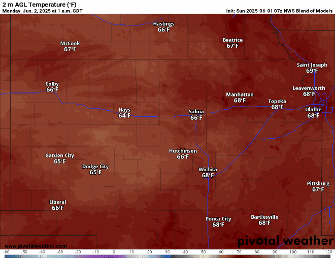
Today offers another very warm and dry day across the area as we get the northern edge of a high-pressure system slide by us. Temperatures will be in the mid-80s by the afternoon, with those north of I-70 having an outside chance of cracking the low 90s. Winds will also pick up in intensity compared to the last few days, with southerly winds blowing at a sustained 10-15 mph and potential gusts up to 20-25 mph. Moisture will also begin to stream northward with these winds, with dew point temperatures climbing into the low/mid-60s. Relative humidity values will continue to hover around 45-55% throughout the day. Overnight tonight, low temperatures will be much warmer in the upper-60s to low-70s.
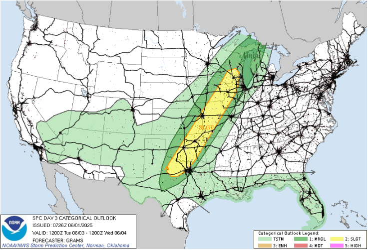
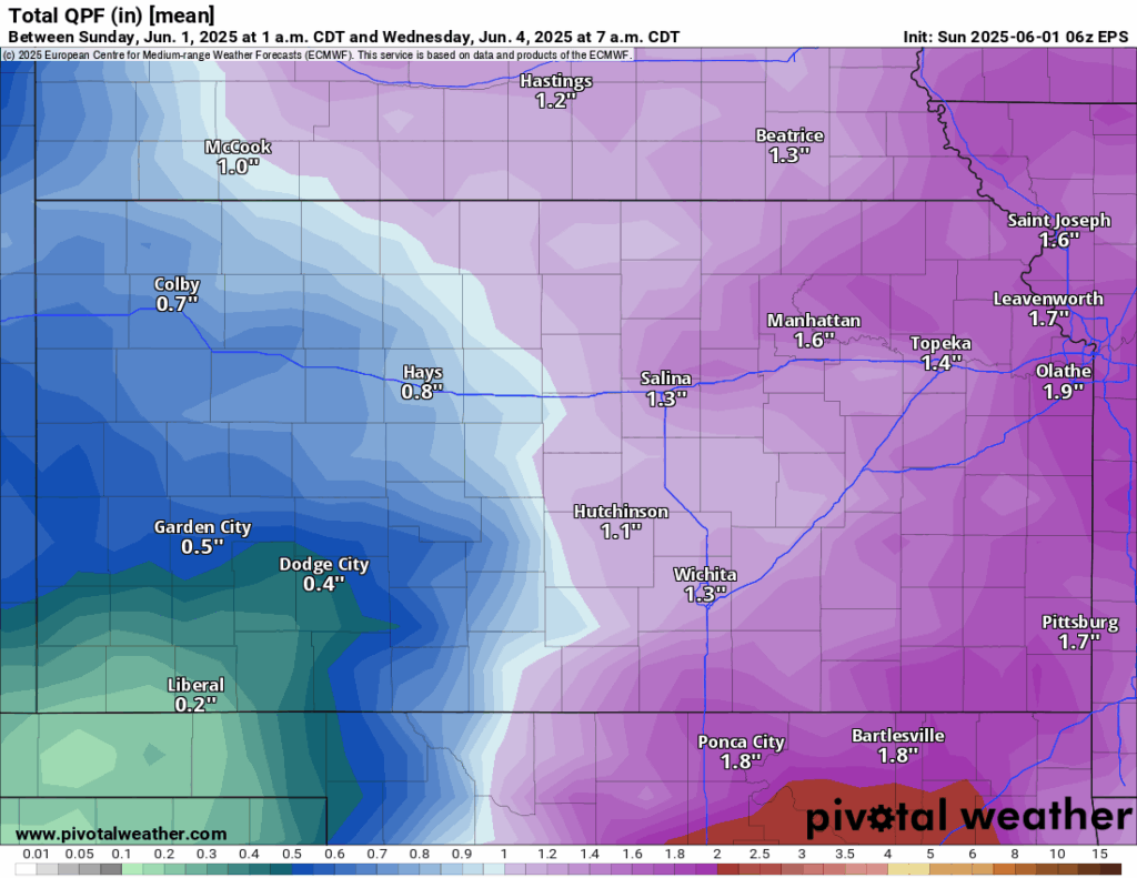
By tomorrow, scattered showers and thunderstorms will be possible starting in the early morning hours as a low-pressure system and associated cold front approaches from the west and displaces our high-pressure off to the east. The early morning round will largely be showers as they advance eastward, but a second round by the afternoon may offer some chance at severe thunderstorms. As of Sunday, the SPC has outlined a Slight Risk (level 2/5) for eastern Kansas, mainly for areas east of I-335/I-35. These storms look to be messier in nature than initially thought and will be highly dependent on how much sunlight we get ahead of the front for these storms to utilize. If indeed these storms do become severe, large hail and damaging winds will be the primary hazard. Widespread flooding is not as much of a concern due to the progressive nature of the front, but localized flooding events may be possible. New rainfall totals from these showers and storms will range between 0.5 to 2 inches across central and eastern Kansas.

Temperatures ahead of the advancing cold front will range from the upper-70s in southeast Kansas, to the low-60s behind the front. Winds ahead of the front will continue to be southerly at 10-20 mph, while winds behind the front will be more northerly at 10-20 mph. Low temperatures Tuesday night will range from the low-50s in north-central Kansas to the upper-50s in southeast Kansas.
Long-Term (Wednesday-Sunday)
After the passage of this cold front by Tuesday evening and the low-pressure system shifts east, we will enter a more zonal (east-west) flow pattern aloft, which may allow for multiple opportunities of showers and thunderstorms throughout the back half of the week and into the weekend. Temperatures throughout the week will be on the cooler side initially, with low-70s likely during the day Tuesday before gradually warming into the low-80s by Sunday. Winds throughout the rest of the week look to be light and variable (<5 mph).
Soil Moisture Update
Due to the brief couple of days of drier conditions, soils have tried to dry somewhat. With this though, 5 cm soil saturation have remained around 60-80%, with very localized pockets of <40% saturation. At 10 cm depth, soils remain slightly more saturated at around 70-90%. With the widespread rain incoming primarily Tuesday and sporadic chances throughout the rest of the week, soils will increase in overall moisture concentration. Any drought conditions or abnormal dryness should continue to gradually improve through the west of the week as well across the region.


