As mentioned by Noah, yesterday, after this front rolled through, it was going to feel a bit drier. And cooler. At least for today, tonight and part of tomorrow.
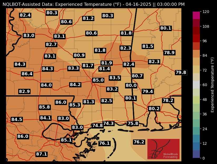
You’ll wake up around 50F but then zoom quickly into the 70s and 80s. When you factor in the sunshine it’ll make it feel like the mid 80s if you’re working outside.
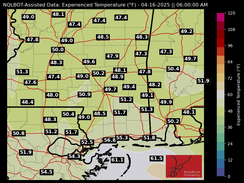
A quick note: I’ve added a handful of locations to the maps, including extra locations in southwest Mississippi, Louisiana and two out in the Gulf. I need to slightly reposition some of these and the placement isn’t as perfect as I’d like.. But hopefully this helps for some of you folks who live around the region.
High temperatures will gradually climb into the upper 80s by the weekend, with a few spots potentially touching 90F by Friday. Despite the warmer weather, fire weather concerns are expected to remain low beyond today. Current conditions suggest that wind and humidity levels won’t reach critical thresholds, but any forecast shifts toward drier or windier setups would raise concern.
Honestly here, if you can avoid outdoor burning, I’d recommend it. And if you need to get some burning done, please just make sure you are taking extra steps (more than usual) to keep things under control.
Moisture will also begin to return heading into the weekend, and then the shot for rain returns by the time we get into early next week. Some guidance kicks storms through late Monday, other models show things firing up on Tuesday. And depending on the model, the threat for storms and the potential for severe weather exists, too, but I think it is a bit too early to be too concerned.
Beyond that, we look to dry back out again for a few days and given the overall pattern we may transition into our “late Spring / early Summer” pattern a bit early this year. That doesn’t mean as much for the temperatures as it does for the risk for severe weather and storms. The shift toward a said pattern would be a lid on the “strong” tornado risk and leave us with more the EF0 and EF1 varieties that develop along boundaries within clusters of storms.
Here’s hoping! We’ve had a pretty rough go of it this year.
REGIONAL DAY TO DAY FORECAST
Tonight: Clear, cooler with lows in the upper 40s. North winds 5 to 10 mph.
Wednesday: Sunny. Highs in the upper 70s. Northeast winds 5 to 10 mph, becoming southeast in the afternoon.
Wednesday Night: Clear. Lows around 50. South winds around 5 mph in the evening, becoming light and variable.
Thursday: Sunny. Highs in the lower 80s. Southeast winds 5 to 10 mph.
Thursday Night: Mostly clear. Lows in the upper 50s.
Friday: Sunny. Highs in the mid 80s.
Friday Night: Partly cloudy in the evening, then becoming mostly cloudy. Lows in the mid 60s.
Saturday: Partly sunny. Highs in the mid 80s.
Saturday Night: Mostly cloudy. Lows in the mid 60s.
Sunday: Mostly cloudy. A slight chance of showers in the afternoon. Highs in the lower 80s. Chance of rain 20 percent.
Sunday Night: Mostly cloudy. A slight chance of showers and thunderstorms after midnight. Lows in the upper 60s. Chance of rain 20 percent.
Monday: Mostly cloudy in the morning, then becoming partly sunny. A chance of showers. A slight chance of thunderstorms in the morning, then a chance of thunderstorms in the afternoon. Highs in the mid 80s. Chance of rain 50 percent.


