Overall Setup
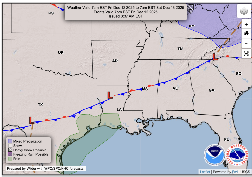
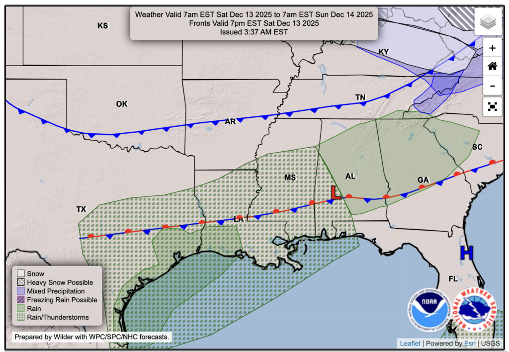
We’ve been discussing the potential for rain from Saturday into Sunday for a few days, and it still appears likely. As shown in the frontal charts above, a stationary front will begin to move south on Friday, arriving at our doorstep by Saturday morning. This front is expected to bring increased cloud cover, along with some scattered showers and possibly a few thunderstorms.
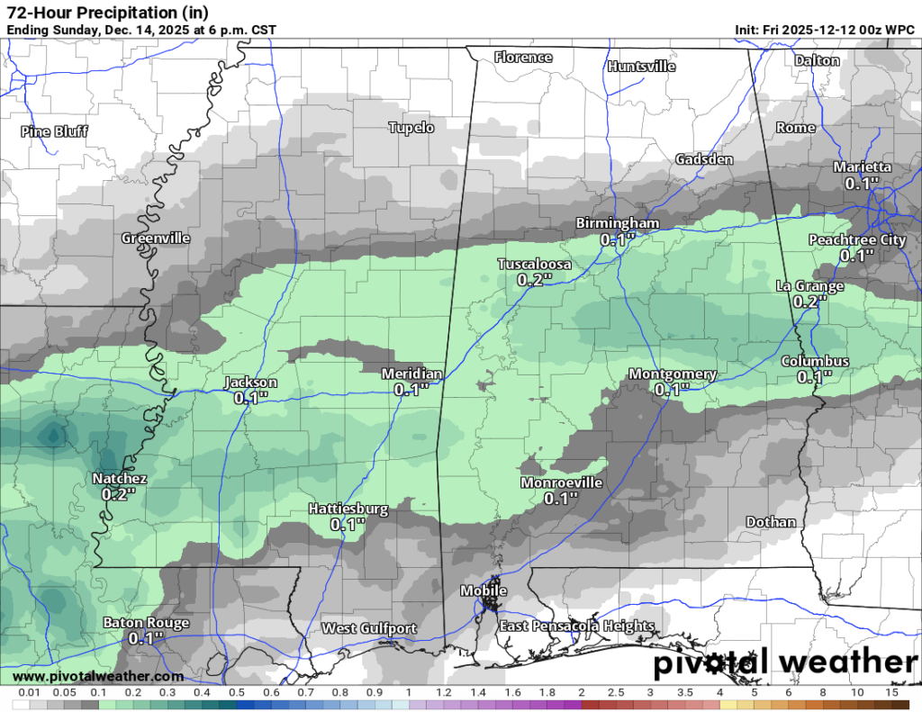
How much rain are we talking about? The WPC is currently showing a few tenths of an inch for the majority of our region, but we know how we tend to overperform with rain along the Gulf Coast, so a half inch up to an inch is certainly possible in isolated areas. Check out the Saturday/Sunday forecasts below for more detailed timing.

Tonight’s Forecast
Tonight, we’re expecting mostly clear skies with temperatures in the lower 40s or high 30s for the mainland, and closer to 50 near the coast.
Tomorrow’s Forecast: Friday, December 12
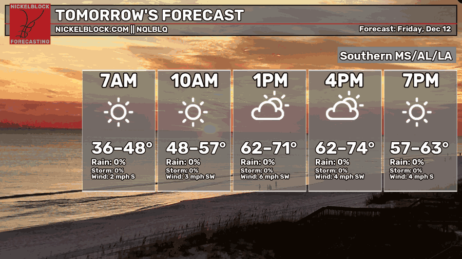
Tomorrow, we will start bright and sunny with only a few clouds around. Throughout the day, you’ll notice some increasing clouds and might feel a quick sprinkle or two as the front starts to pull some moisture northwards towards itself. However, the majority will stay dry for the day. Highs will top out in the upper 60s, and lows will be much milder than the more recent nights, and especially more mild than some of the upcoming nights ahead, in the low to mid 50s!
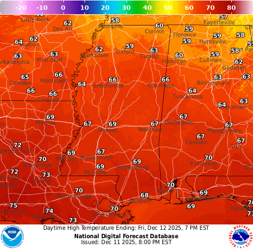
Saturday’s Forecast: December 13
By Saturday, the front has brought up moisture out of the Gulf to work with, which will bring lots of cloud cover and an increased chance of some pre-storm showers. As you can see, the Euro model, along with some other models, is showing the chance for rain and possibly some thunderstorms Saturday afternoon into the evening. These will be more scattered in nature, before more widespread rain takes over into Saturday night.
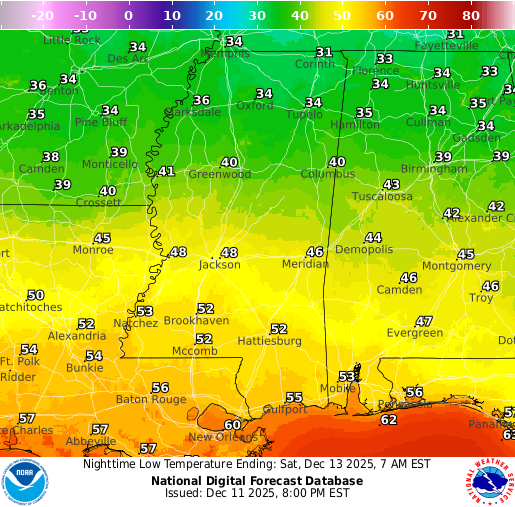
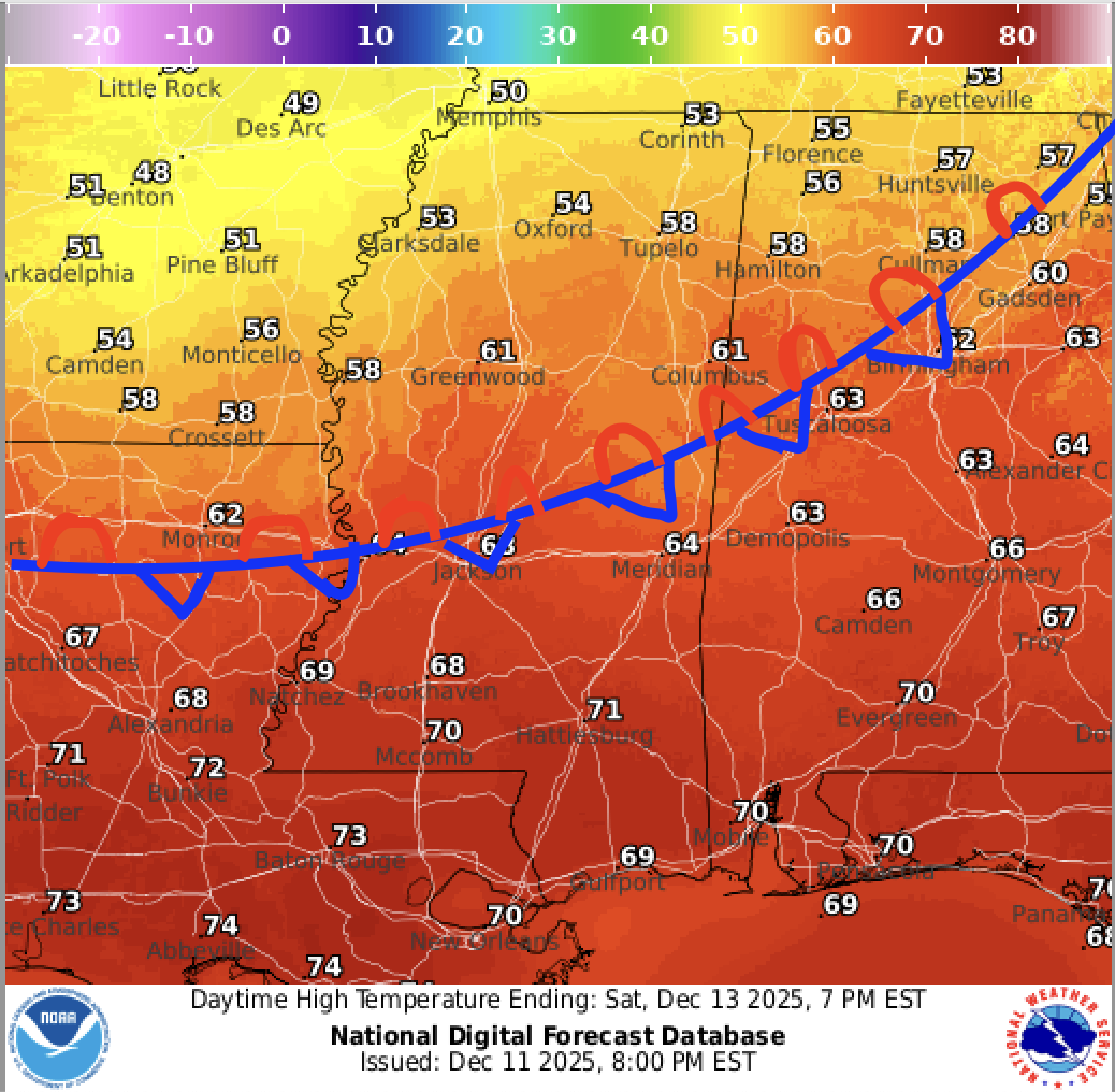
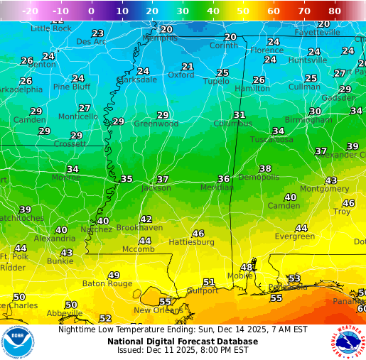
Sunday’s Forecast: December 14
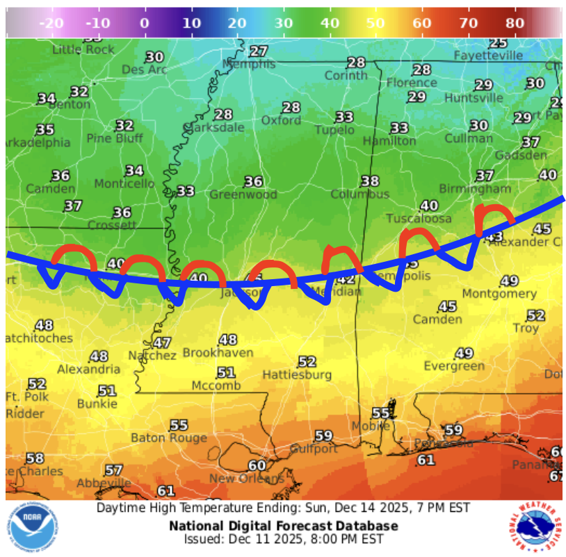
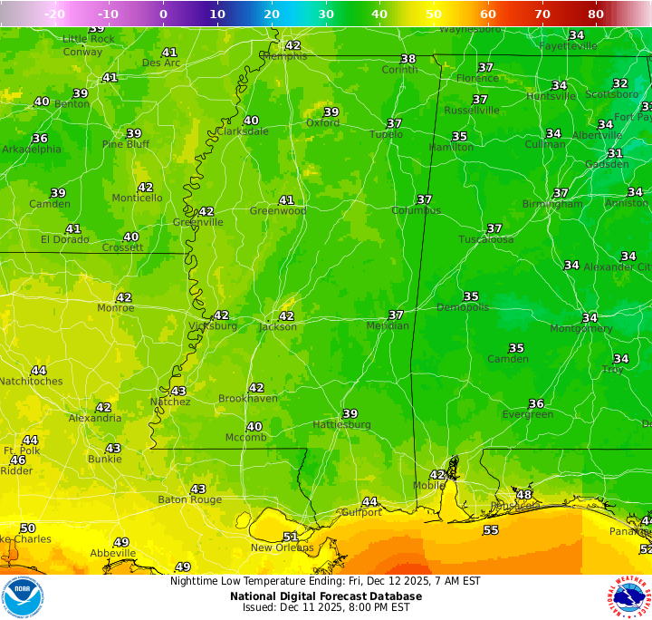
Rain becomes more filled in by midnight before finishing off by around 6 am or so. After the rain is over, Sunday is actually expected to be a really nice day filled with sunshine. Take a look at the highs for Sunday – there’s about a 20-degree temperature gradient due to the difference in wind direction because of the presence of the front, which happens to be sitting right over central Mississippi! Those in far northern Mississippi and Alabama are looking to have a high temperature in the 20s on Sunday, talk about extreme! *Don’t mind my horrible drawing*
Extended Local Outlook
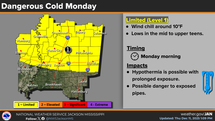
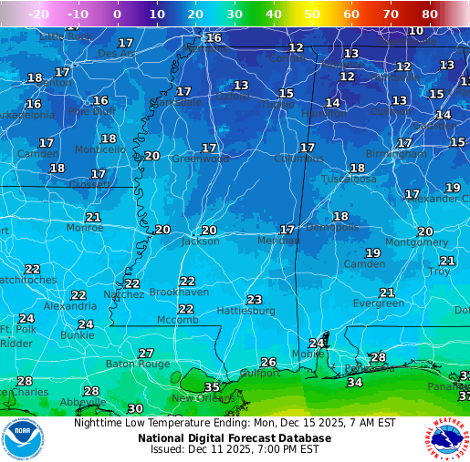
While southern MS, AL, and LA will not see the cold on Sunday, we will be feeling the cold on Monday morning. Temperatures are currently forecasted to reach the lower 20s, with wind chills making it feel like the teens. The NWS has posted a Limited (Level 1/4) threat on the Dangerous Cold scale for those folks in Vicksburg, Jackson, Meridian, and areas further north. Ensure you are prepared on Monday morning and the kids are all bundled up for school. A chilly high for Monday as well, only in the mid-40s!
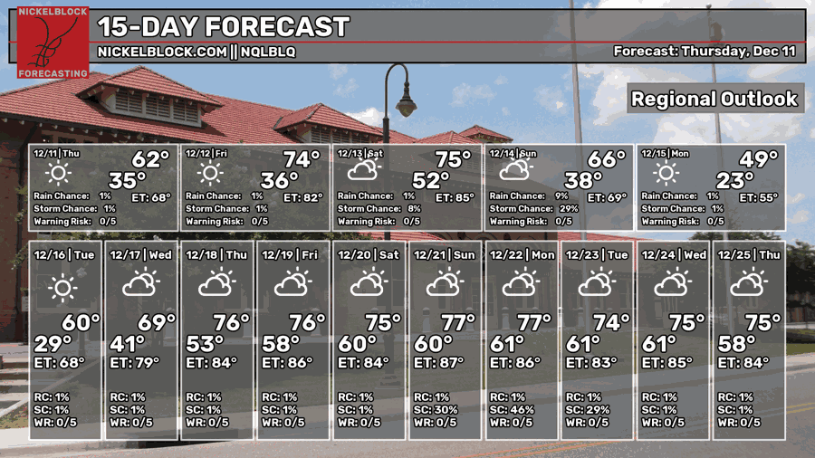
Not a fan of the cold? You have a warmup to look forward to! Mid to late December will include a likely warmup for us, with temperatures for Christmas sitting at 75 degrees, according to our own NQLBLQ model. We’re also looking at some lower precipitation chances after this weekend, so not much in the way of soaking rain at least for a little while.

REGIONAL DAY TO DAY FORECAST
Tonight: Mostly clear. Lows in the lower 40s. Calm wind.
Friday: Mostly sunny. Highs in the upper 60s. Calm wind becoming southwest around 5 mph.
Friday Night: A slight chance of showers after 7 p.m. Patchy fog early in the evening. Otherwise, mostly cloudy. Lows in the lower 50s. Calm wind. Chance of rain 20 percent.
Saturday: A slight chance of showers. Partly sunny. Highs in the lower 70s. Calm wind becoming south around 5 mph. Chance of rain 40 percent.
Saturday Night: A chance of showers in the evening, then a chance of showers and thunderstorms between 9 p.m. and midnight. Showers likely after midnight, with a chance of a thunderstorm. Mostly cloudy. Lows in the mid 40s. Light wind becoming north 5 to 10 mph after midnight. Chance of rain 80 percent.
Sunday: Mostly sunny. Perhaps a morning shower leftover. Cooler. Highs in the lower 50s. North wind 10 to 15 mph, with gusts up to 25 mph.
Sunday Night: Clear. Very cold. Lows in the lower 20s. North-northeast wind 5 to 10 mph, with gusts up to 25 mph.
Monday: Sunny. Highs in the mid 40s. North-northeast wind around 5 mph becoming calm in the afternoon.
Monday Night: Mostly clear. Lows in the upper 20s. Calm wind.
Tuesday: Mostly sunny. Highs in the upper 50s.
Tuesday Night: Mostly cloudy. Lows around 40.
Wednesday: A slight chance of showers. Partly sunny. Highs in the upper 60s. Chance of rain 20 percent.
Wednesday Night: A slight chance of showers. Partly cloudy. Lows in the lower 50s. Chance of rain 20 percent.
Thursday: A slight chance of showers. Mostly sunny. Highs in the lower 70s. Chance of rain 20 percent.


