The Southeast has suffered long enough! The heat and humidity drawn in from the Gulf of Mexico by the Southeastern ridge has made June abnormally warm. However, that ridge is shifting to the west and will settle over the Southwest and Texas, leading to a heatwave in the Central US and near average temperatures in the Southeastern US.

As the ridge of high pressure builds in the West, a zonal wind pattern will be created, resulting in westerly winds throughout the Southeast. In order to receive excessive heat and humidity in the region, winds typically need to be coming out of the south.
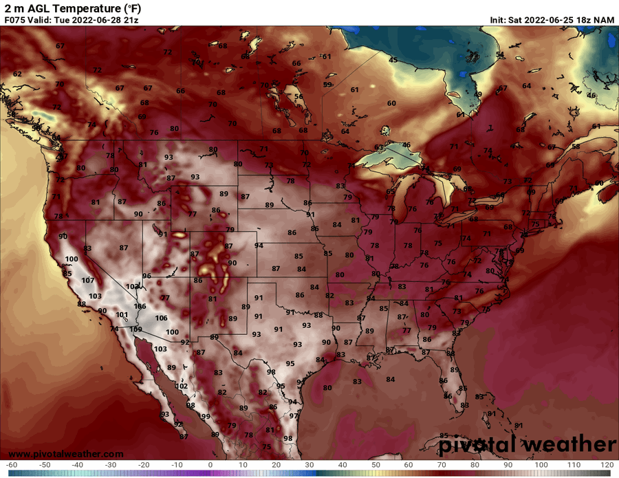
Since this will no longer be the pattern for the next week, temperatures throughout the atmospheric column are expected to reduce, leading to climatologically normal conditions east of Texas. These temperatures will reach the upper 80s in the lower Mississippi River Valley and Florida while the rest of the Southeast stays in the low-to-mid 80s. Unfortunately, Texas is will remain in the low-to-mid 90s, though this is still a cool-down from the triple digit temperatures the state experienced last week.

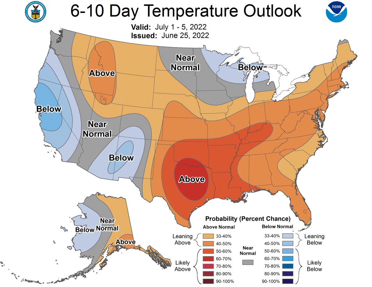
Though next week’s pattern is favorable for near average temperatures, conditions will begin to heat up in the 6-to-10 day stretch, according to the Climate Prediction Center. The ridge is expected to remain in the Central US for the next several days but is expected to strengthen.
As the ridge intensifies, high pressure will begin to build back into the Southeast, resulting in temperatures slightly above average. Because the region will not be directly under a ridge of high pressure, rain will be a more common occurrence, with normal to slightly above normal amounts expected east of Texas.

The minimal precipitation in Texas is not ideal, considering most of the state of Texas is in some type of a drought. As a result, expect to see drought conditions slowly worsen over the next couple of weeks. Above average rainfall is expected in the Carolinas which should help reduce the drought that is developing in that region.

Something else that may help relieve drought-stricken communities along the Northern Gulf Coast is the potential development of system offshore. The National Hurricane Center has assigned a 20% chance of tropical development in the next 5 days for a low pressure system in the Gulf of Mexico. Any development could increase convection, leading to more showers along the coast of Texas and Louisiana.

For more information about the tropics, visit that part of our website by clicking here and going to the outlook and latest tabs. Posts with more specific information will also be made here.
Local 3 Day Forecasts (Courtesy: NWS)
| Dallas, TX | ||
| Sunday | Monday | Tuesday |
| High: 101F | High: 91F | High: 92F |
| Low: 74F | Low: 72F | Low: 72F |
| Precip: 30% | Precip: 20% | Precip: None |
| Atlanta, GA | ||
| Sunday | Monday | Tuesday |
| High: 89F | High: 89F | High: 82F |
| Low: 72F | Low: 70F | Low: 68F |
| Precip: 30% | Precip: 50% | Precip: 70% |
| Houston, TX | ||
| Sunday | Monday | Tuesday |
| High: 99F | High: 93F | High: 89F |
| Low: 78F | Low: 76F | Low: 76F |
| Precip: 30% | Precip: 60% | Precip: 50% |
| Birmingham, AL | ||
| Sunday | Monday | Tuesday |
| High: 93F | High: 88F | High: 88F |
| Low: 73F | Low: 68F | Low: 70F |
| Precip: 40% | Precip: 60% | Precip: 40% |
| Little Rock, AR | ||
| Sunday | Monday | Tuesday |
| High: 94F | High: 84F | High: 85F |
| Low: 69F | Low: 63F | Low: 63F |
| Precip: 50% | Precip: None | Precip: None |
| New Orleans, LA | ||
| Sunday | Monday | Tuesday |
| High: 95F | High: 92F | High: 91F |
| Low: 80F | Low: 80F | Low: 80F |
| Precip: 60% | Precip: 60% | Precip: 60% |
| Memphis, TN | ||
| Sunday | Monday | Tuesday |
| High: 96F | High: 85F | High: 88F |
| Low: 71F | Low: 65F | Low: 66F |
| Precip: 50% | Precip: None | Precip: None |


