summertime front is heading our way from the north, but don’t get too excited, this won’t usher in a big cool down. That said, the shot for rain will get a bump this evening. With all the heat and humidity in place, a few storms could pack a punch with damaging winds, similar to what we saw yesterday in parts of Arkansas, northwest Mississippi, and north Louisiana.
Most storms should wind down by late evening, though an isolated one or two could hang on overnight.

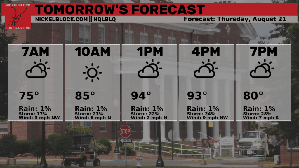
Tomorrow the front will stall out around and north of I-20. So, south of I-20, the sticky air hangs on and heat indices could still run high…. unless afternoon storms develop early enough to knock temperatures back for a bit.
The NQLBOT forecast data is again a bit too dry. I’ll try to get on that ASAP.
Looking toward the weekend, the region splits in two: the north sees drier, more tolerable weather, while the south stays muggier with scattered afternoon storms. Clouds and rain may help keep heat stress from getting as extreme as it has been, but it’ll still feel plenty summery.
By early next week, a reinforcing front arrives. This should lower rain chances across the whole area and could knock highs back into the upper 80s with some spots may not even hit 90 by Tuesday. After the stretch we’ve had, that will be a welcome change.
REGIONAL DAY TO DAY FORECAST
Wednesday Night: Partly cloudy with a slight chance of showers and thunderstorms in the evening, then mostly clear after midnight. Lows in the mid 70s. Southwest winds around 5 mph in the evening, becoming light and variable. Chance of rain 20 percent.
Thursday: Sunny. Showers and thunderstorms likely in the afternoon. Humid with highs in the mid 90s. Northwest winds around 5 mph. Chance of rain 60 percent. Heat index values up to 105.
Thursday Night: Mostly cloudy with a chance of showers and thunderstorms in the evening, then partly cloudy after midnight. Lows in the lower 70s. Southwest winds around 5 mph in the evening, becoming light and variable. Chance of rain 30 percent.
Friday: Mostly sunny. A slight chance of showers and thunderstorms in the morning, then showers and thunderstorms likely in the afternoon. Highs in the lower 90s. Chance of rain 60 percent.
Friday Night: Mostly cloudy with a slight chance of showers and thunderstorms in the evening, then partly cloudy after midnight. Lows in the lower 70s. Chance of rain 20 percent.
Saturday: Mostly sunny. A slight chance of showers and thunderstorms in the morning, then a chance of showers and thunderstorms in the afternoon. Highs in the lower 90s. Chance of rain 50 percent.
Saturday Night: Partly cloudy. Lows in the lower 70s.
Sunday: Mostly sunny. A chance of showers and thunderstorms in the afternoon. Highs in the lower 90s. Chance of rain 30 percent.
Sunday Night: Partly cloudy in the evening, then becoming mostly clear. Lows in the lower 70s.
Monday: Sunny. A slight chance of showers and thunderstorms in the afternoon. Highs in the mid 90s. Chance of rain 20 percent.
Monday Night: Mostly clear. Lows in the upper 60s.
Tuesday: Sunny. A slight chance of showers and thunderstorms in the afternoon. Highs in the lower 90s. Chance of rain 20 percent.


