The week ahead brings classic late-summer conditions to the Gulf states, characterized by intense heat, humid air, and intermittent thunderstorms, especially in the afternoon and early evening hours. The region will experience a cycle of scattered rain events, sunny breaks, and muggy nights, as upper-level ridges and weak tropical impulses compete for dominance.
Stormy Start, Then Brighter Skies: Thursday–Saturday

500 mb map for Thursday from the NAM model. //Courtesy: College of DuPage
A weak frontal boundary interacting with a deep plume of tropical moisture drifting northward from the Gulf will set the stage for widespread thunderstorm development on Thursday across the Deep South. The atmospheric setup is primed for convective activity, with localized flooding possible in low-lying and urban areas, especially around the Alabama foothills and coastal Louisiana, where terrain and sea breeze interactions will enhance uplift. Frequent lightning and gusty winds will also be a concern as unstable air builds through the afternoon. By Friday and Saturday, a transient high-pressure ridge slides overhead, briefly stabilizing the region’s weather pattern. This will bring mostly sunny skies to central Mississippi and southern Louisiana, reducing rainfall chances and allowing for clearer, albeit hot and humid, conditions. However, Alabama may remain unsettled, particularly on Saturday, due to a subtle upper-level trough grazing the area, keeping scattered showers in the forecast. Despite these variances, the entire region will experience high temperatures between 88°F and 93°F, with heat indices frequently surpassing 105°F, creating hazardous conditions for prolonged outdoor exposure.
Patchy Storms & Slight Cooling: Sunday–Monday
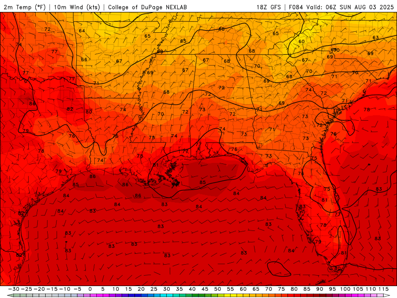
Surface Temperatures for Sunday and Monday from the GFS model. //Courtesy: College of DuPage
During the early part of the week, Louisiana and Mississippi will enjoy a brief period of meteorological stability as upper-level ridging and subdued moisture transport lead to a reduction in organized thunderstorm activity. This results in mostly sunny skies, lower cloud coverage, and slightly reduced humidity, particularly noticeable during the morning and evening hours. Dew points dip modestly, making outdoor conditions feel less oppressive compared to the storm-laden days prior. Meanwhile, Alabama remains under the influence of a cyclonic curvature near Georgia, which enhances uplift and moisture convergence across the eastern part of the state. As a result, heavier rain showers are likely on Sunday, particularly during the afternoon and early evening, followed by more isolated, spotty rainfall on Monday. Cloud cover will limit daytime heating in Alabama, leading to cooler maximum temperatures in the low 80s, while inland areas of Louisiana and Mississippi maintain average highs around 91°F, accompanied by lingering summer warmth.
Gulf Breezes Bring Showers Back: Tuesday–Thursday
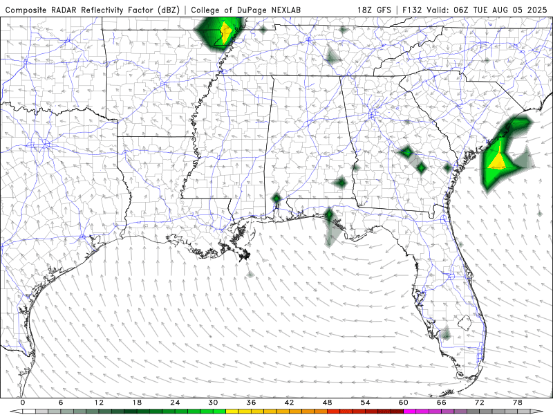
Radar for Tuesday through Thursday of next week from the GFS model. //Courtesy: College of DuPage
By midweek, the atmospheric setup across the Deep South shifts as a strengthening southerly flow draws rich Gulf moisture northward, increasing instability and cloud formation throughout the day. This moisture surge sets the stage for renewed thunderstorm development, particularly during the afternoon and evening hours when surface heating peaks. In Louisiana and Mississippi, sea breeze boundaries and weak upper-level disturbances will interact to trigger scattered convective storms, often fast-moving but locally intense, capable of producing strong wind gusts, frequent lightning, and brief urban flooding, especially in poorly drained city areas. Meanwhile, Alabama experiences a drying trend on Wednesday, with subsidence from a passing ridge limiting precipitation. By Thursday, the state enjoys mostly sunny skies, and temperatures rebound into the upper 80s, returning to seasonal norms. Despite the hit-or-miss nature of rainfall across the region, the potential for isolated severe cells remains elevated due to lingering humidity and pockets of atmospheric instability.
Regional Day-to-Day Forecast
Thursday – Partly sunny across the region with a few afternoon showers possible in southern Louisiana and coastal Mississippi. Alabama stays mostly dry. Highs range from 93–96°F. Heat index values peak near 107°F. Light west winds around 5 mph.
Thursday Night – Mostly clear skies with patchy clouds. Lows range from 75–79°F. Winds light and variable. Slight chance of isolated showers near the Gulf Coast.
Friday – Scattered thunderstorms likely in Louisiana and central Mississippi during the afternoon. Alabama sees more sunshine with isolated coastal convection. Highs near 91–94°F. Heat index values reach 105–108°F. Calm winds becoming west at 5 mph.
Friday Night – Partly cloudy with a few lingering showers. Lows around 74–78°F. Winds light from the northwest.
Saturday – Mostly sunny with only a slight chance of isolated storms across the region. Highs near 91–93°F. Heat index values around 102–106°F. Northwest winds 5 to 10 mph.
Saturday Night – Clear to partly cloudy. Lows range from 72–76°F. Winds light and variable.
Sunday – Sunny and dry across all three states. Highs near 91–92°F. Heat index values around 100–104°F. Light north winds.
Sunday Night – Mostly clear skies. Lows around 73–77°F. Winds calm.
Monday – Mostly sunny with a few pop-up showers possible in southern Louisiana. Mississippi and Alabama remain dry. Highs near 92–94°F. Heat index values around 104–107°F. Winds light and variable.
Monday Night – Partly cloudy with a slight chance of showers near the coast. Lows from 74–78°F. Winds light from the southeast.
Tuesday – Sunny skies dominate with only isolated convection near the Gulf Coast. Highs near 93–95°F. Heat index values climb to 106–109°F. Light southeast winds.
Tuesday Night – Mostly clear with warm and humid conditions. Lows around 75–79°F. Winds light from the south.
Wednesday – Continued hot and mostly sunny. Spotty afternoon storms possible in Louisiana and Mississippi. Alabama stays mostly dry. Highs near 94–96°F. Heat index values reach 108–110°F. South winds 5 to 10 mph.
Wednesday Night – Partly cloudy with a few isolated showers. Lows from 76–80°F. Winds light and variable.
Thursday – Scattered thunderstorms return to Louisiana and central Mississippi. Alabama sees more sunshine with isolated coastal showers. Highs near 93–95°F. Heat index values around 105–108°F. Southwest winds 5 to 10 mph.
Thursday Night – Mostly clear with patchy clouds. Lows range from 75–79°F. Winds light from the southwest.


