The week ahead across the Gulf coast brings a dynamic mix of summer extremes. Tuesday and Wednesday start hot and stable under a high-pressure ridge, with highs near 95°F and isolated pop-up showers inland. By Thursday through Saturday, tropical moisture and an upper-level trough trigger widespread thunderstorms, with Friday being the most active. Expect heavy rainfall, gusty winds, and flash flooding in vulnerable areas. As the region heads into Sunday and Monday, drier air returns, minimizing storm chances and restoring more typical summer sunshine and heat.
Stable and Hot Conditions — Tuesday & Wednesday
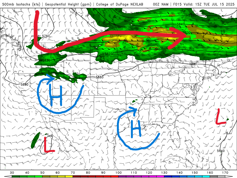
500 mb map for Tuesday from the NAM model. //Courtesy: College of DuPage
Tuesday and Wednesday begin under the influence of a strong high-pressure ridge centered over the Southeast. This creates stable conditions with subsidence aloft suppressing convective development, resulting in clear skies and intense solar heating. Daytime highs reach the mid-90s with dew points in the mid-70s, pushing heat indices into the 105°F range. On Wednesday, the ridge weakens slightly, allowing moisture from the Gulf to seep in. This ups humidity and introduces a narrow window for isolated diurnal thunderstorms, mainly inland where afternoon instability rises.
Enhanced Moisture & Scattered Thunderstorms — Thursday to Saturday
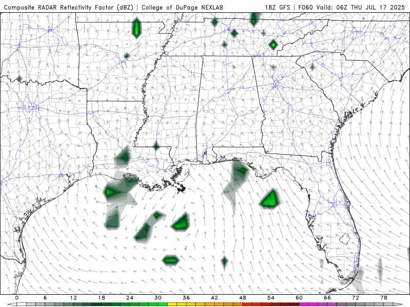
Composite Radar Reflectivity for Thursday through Saturday from the GFS model. //Courtesy: College of DuPage
From Thursday to Saturday, the region transitions to a wetter and more convectively active regime. A weak upper-level trough brushes across the Deep South while tropical moisture surges northward, increasing PWATs to 1.8–2.0 inches. This destabilizes the atmosphere, creating favorable conditions for scattered thunderstorms. Friday sees the greatest rain coverage, driven by surface convergence and rich thermodynamics, with storms capable of intense downpours and flash flooding. Saturday maintains residual instability with less organized cells, yet afternoon storms remain likely due to lingering outflow boundaries and high surface moisture.
Drying Trend & Return to Stability — Sunday & Monday
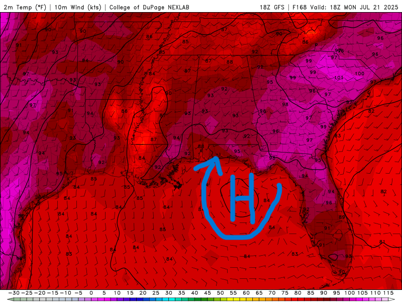
High Temperatures for next Monday from the GFS model. //Courtesy: College of DuPage
Sunday and Monday mark a subtle shift back toward atmospheric stability. Drier mid-level air and the return of upper-level ridging suppress widespread convection. Sunday may still see isolated showers due to leftover surface moisture and heating, but overall storm activity wanes. By Monday, convective inhibition (CIN) rises, minimizing rain chances and allowing temperatures to climb into the low 90s. Skies turn mostly sunny, with humidity dipping slightly and a return to more typical summer conditions.
Regional Day-to-Day Forecast
Tuesday – A 40% chance of showers and thunderstorms. Mostly sunny, with a high near 93°F. Heat index values may reach 106°F. Northwest wind around 5 mph becoming southwest in the afternoon.
Tuesday Night – A 20% chance of showers and thunderstorms. Partly cloudy, with a low around 77°F. Southwest wind around 5 mph becoming northwest after midnight.
Wednesday – Showers and thunderstorms likely. Partly sunny, with a high near 93°F. North wind around 5 mph becoming south in the afternoon. Chance of precipitation is 60%.
Wednesday Night – A 60% chance of showers and thunderstorms. Mostly cloudy, with a low around 75°F. North wind around 5 mph becoming east after midnight.
Thursday – Showers likely and possibly a thunderstorm. High near 88°F. Northeast wind 5–10 mph becoming southeast in the afternoon. Chance of precipitation is 90%.
Thursday Night – A 70% chance of showers and thunderstorms. Mostly cloudy, with a low around 76°F. Southeast wind around 5 mph.
Friday – Showers and possibly a thunderstorm. Partly sunny, with a high near 87°F. South wind 5–10 mph. Chance of precipitation is 80%.
Friday Night – A 50% chance of showers and thunderstorms. Mostly cloudy, with a low around 76°F. South wind around 5 mph.
Saturday – Showers and thunderstorms likely. Partly sunny, with a high near 89°F. South wind 5–10 mph. Chance of precipitation is 70%.
Saturday Night – A 40% chance of showers and thunderstorms. Partly cloudy, with a low around 77°F. South wind around 5 mph.
Sunday – Showers and thunderstorms likely. Mostly sunny, with a high near 91°F. West wind 5–10 mph becoming south in the afternoon. Chance of precipitation is 60%.
Sunday Night – A 30% chance of showers and thunderstorms. Partly cloudy, with a low around 77°F. Southwest wind around 5 mph.
Monday – A 50% chance of showers and thunderstorms. Mostly sunny, with a high near 92°F. Southwest wind 5–10 mph.
Monday Night – A 40% chance of showers and thunderstorms. Partly cloudy, with a low around 77°F.


