General Central/Eastern Kansas Forecast
Short-Term (Friday-Sunday)
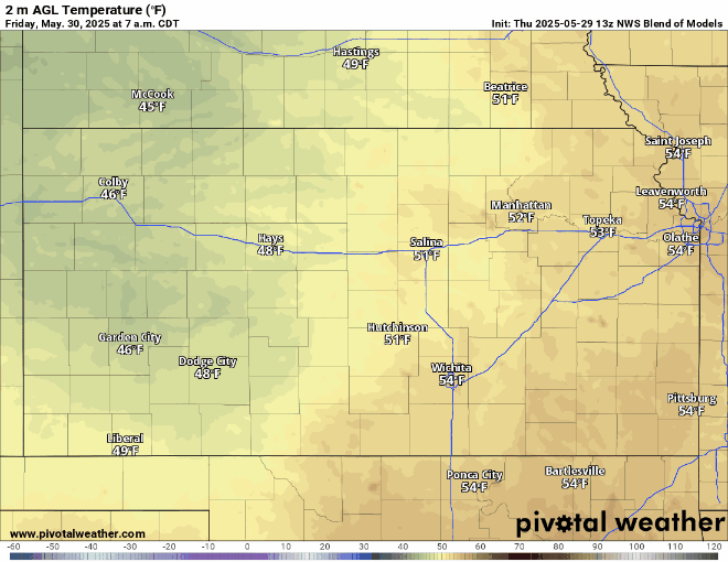
Drier conditions will largely set in for a few days across the region as higher pressure tries to move in over the weekend, save for some thunderstorm chances Saturday evening. High temperatures will begin to become more seasonal, reaching the mid 70s by this afternoon before making it into the low/mid 80s Saturday and Sunday. Low temperatures throughout the short-term period will also increase reaching the upper 50s to low 60s Friday night/Saturday morning and Saturday night/Sunday morning. Winds throughout the day today will be generally out of the north-northwest at 5 mph, before becoming light and variable by Saturday. Thunderstorms now do appear possible Saturday evening across central to southeast Kansas, as a shortwave quickly moves through the state from north to south. Depending on instability and wind shear, some small hail may be possible with these storms. By Sunday, storms will have moved out of the area and will go back to staying dry for another day or so. Winds will again be northerly at around 5 mph. Relative humidity values throughout the day Friday-Sunday will largely remain between 45-50%, although areas north of I-70 and closer to the Nebraska border may dip down to between 30-35%.
Long-Term (Monday-Thursday)
By Monday, we will see a pattern shift as another system and associated cold front approaches from the northwest and may have notable effects on central/eastern Kansas. In response to this incoming system, we will see southerly flow return and bring rich, gulf moisture to the area to help set the stage for potential severe weather on Tuesday. Dew point temperatures Monday will reach the upper 60s to low 70s and relative humidity values climbing as well to between 50-55%. Similar to the previous days, high temperatures will be between the low to mid 80s. Winds on Monday will be considerably stronger than over the previous few days, being sustained at 10-15 mph out of the south, with potential gusts up to 25 mph. Depending on the progression of this system and placement of the front, showers and thunderstorms will be possible Monday night/Tuesday morning.

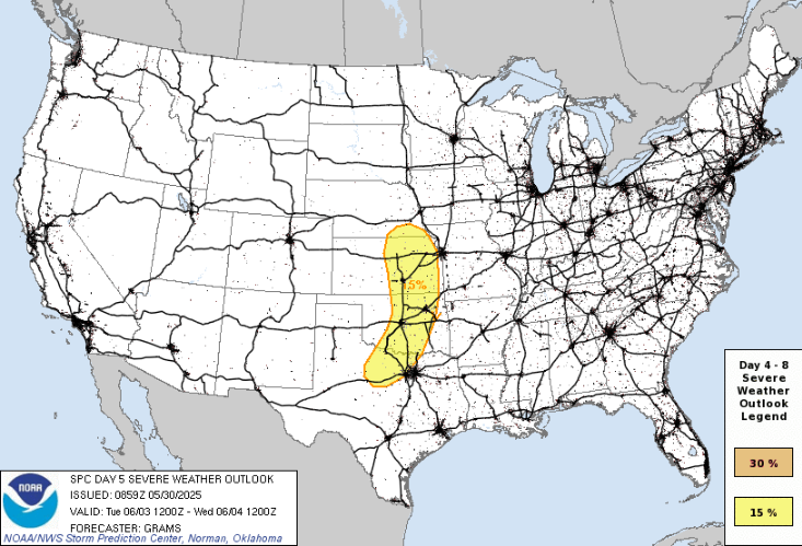
Tuesday, conditions may be favorable for the development of severe thunderstorms across the area. Very rich moisture will continue to stream northward, with dew point temperatures across central and eastern Kansas reaching the low to mid 70s. Winds in front of this system will be very breezy, being sustained at 15 to 25 mph out of the south and gusts approaching 30-35 mph. Exact details regarding storm mode and evolution still are yet to be determined at this range, but given the overall wind profile and shear orientation, supercell thunderstorms will be capable of large hail and damaging winds.
As this system moves off Tuesday night/Wednesday morning, a weak cold front will sweep through the area and drop our temperatures somewhat down to the mid/upper 70s by Wednesday afternoon. This cold front will yield to quieter weather once it passes, keeping us drier heading into Thursday.
Soil Moisture/Drought Update
Soils will begin to steadily dry over the next few days as we enter a period of quieter weather. Current 10cm soil saturation is still around 80-90% for the majority of central and eastern Kansas, with lower values around 40-70% near the Nebraska border.
Due to the recent rains, we have seen some drought improvement across Kansas, with large areas across central and eastern Kansas improving to abnormally dry conditions or no drought conditions as of the most recent update.


