Happy Valentine’s Day. You may not love this forecast. But I wrote your a short sonnet:
Roses are red
Violet is purple
I like science
So this forecast is based on data, not poetry.
People have accused me of being “Sheldon” a ttimes and I think this may go down as one of them. ha. Anyway! To the weather!
We have the risk for storms tonight as we move through the overnight hours. The Storm Prediction Center has parts of the area under a Slight Risk and other sections under a Marginal risk for severe weather.
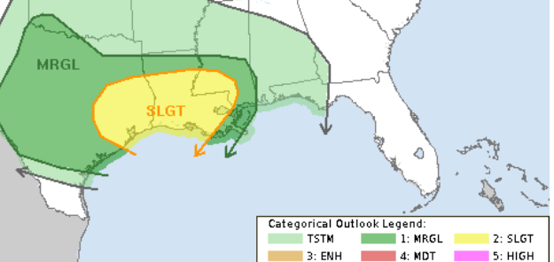
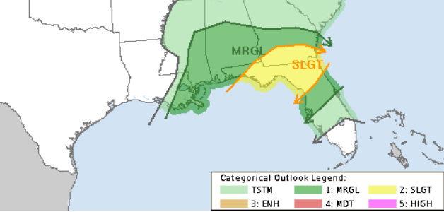
The Slight Risk is a “2” on the 1-to-5 scale, where a “5” is the highest risk for the most significant severe weather. A Marginal Risk is a “1” on the same scale. And the values are for a severe storm within 25 miles of a point. So the lines are less “black and white” than they appear on these maps.

WHAT’S HAPPENING
As we move through the overnight hours tonight a line of storms will kick through the entire region. NEarly everyone will get rain tonight. Just about everyone will hear a rumble of thunder or two, as well. But! The storms that move through won’t be strong enough to be considered “Severe” everywhere.
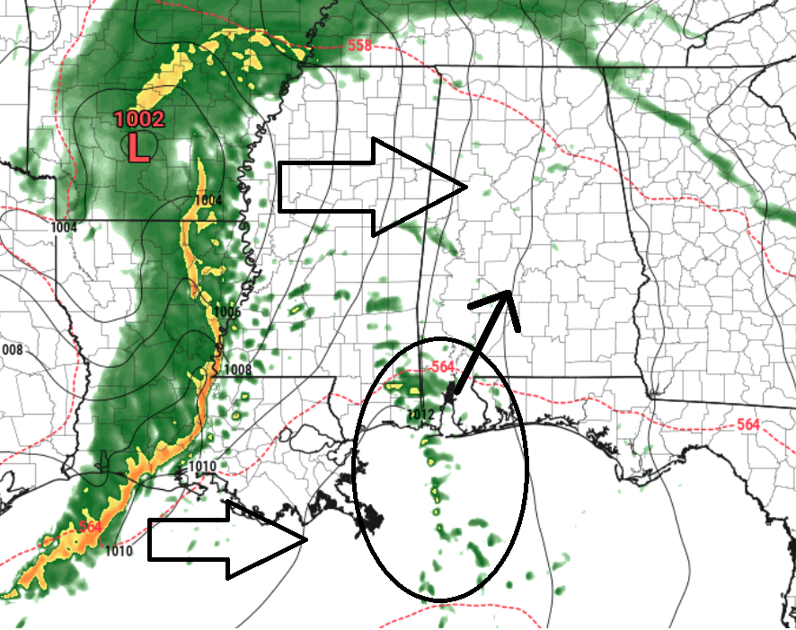
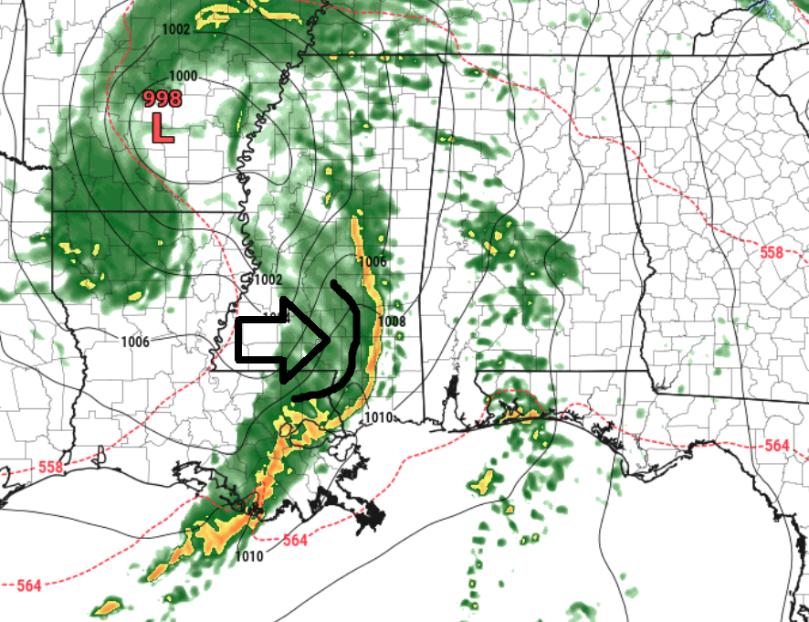
A line of storms will reach the Louisiana–Mississippi border around 10–11 tonight. The whole line will move from west to east. But the storms inside the line will slide a little from southwest to northeast. That means some storm warnings may move a different way than the line itself.
On top of that, there is some indication that a daisy-chain of storms may develop ahead of the line somewhere (on this map it is near the Mississippi / Alabama border and down into the Gulf, but the location isn’t set in stone) and those storms may have a bit more of a propensity to spin and produce some hail. The tornado risk from those storms is going to be very conditional.
I think a safe bet on a forecast for everyone looks liek this:
EVERYONE: A single round of heavy rain and wind gusts up to 35mph
SOME PLACES: A single round of very heavy rain, wind gusts up to 45mph, and small hail
A FEW SPOTS: A single round of very heavy rain, some flash flooding, wind gusts up to 65mph, small hail and the chance at a tornado
Not everyone is going to get the roughest of the rough weather tonight. In fact most folks will get a good shot of rain and some gusty wind and that’s all. But given the risk for a tornado, it is best to make sure you have a way to get alerts from the NWS
DOWNLOAD THE APP

The NickelBlock Forecasting Weather App is a great way to make sure you can get pings from the NWS for Watches, Warnings and Advisories.
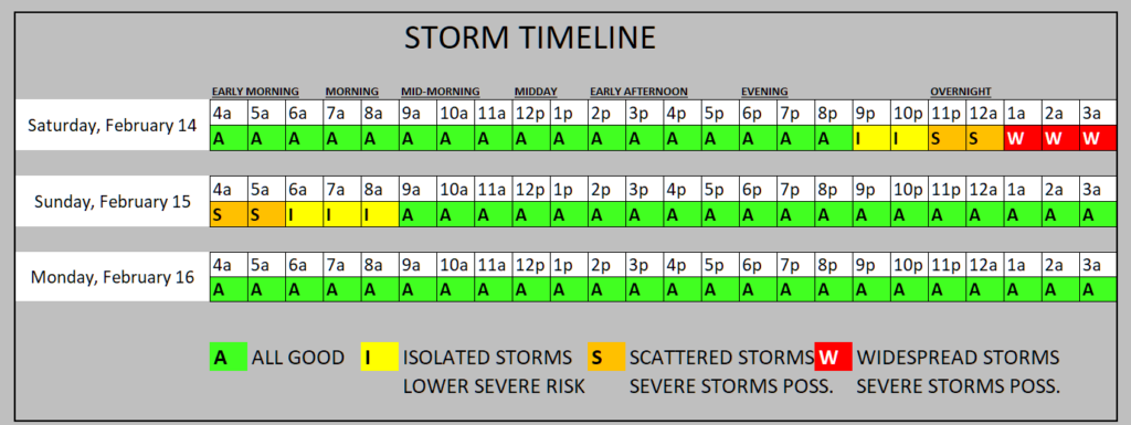
TIMELINE
Here is a quick look at the timeline for storms. While this is a general outlook, you can easily make it slightly more applicable to your specific location. If you live farther west, move the timing up about an hour or two. If you live farther east across our area, move this timeline back an hour or two.
NERD ALERT!
Looking at the Skew-T charts to get a better idea about the structure of the atmosphere around these storms, we can see that there are going to be a lot of ingredients for tornadoes — but not all of the ingredients will be exactly how we need them for certain
This first chart is along the Louisiana Mississippi border near Natchez at about 10p/11p.
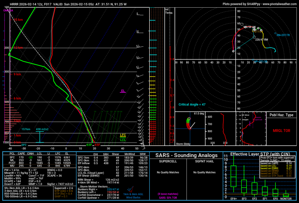
In this case, we have plenty of wind, it is turning with height, there is ample shear, too. But we have a limited amount of mixed-layer instability (ML CAPE) and even our Downdraft CAPE isn’t too high.
So the risk for tornadoes at that time will be “Conditional” to places where the atmosphere can tap into high instability values. And we can’t really know where those places will be quite yet.
At the same time, picking a point near that daisy-chain cluster of storms, we see a bit more instability. And we continue to see good shear and a solid wind profile.
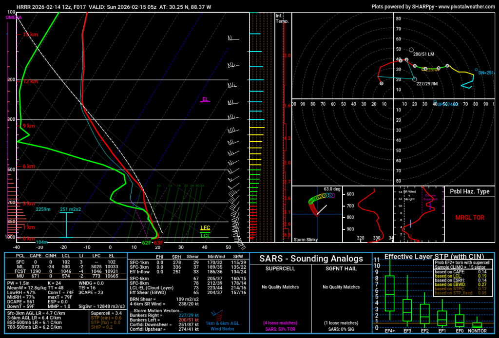
However! These storms will not be surface-based according to this sounding. That means all of the ingredients we need to make severe weather an da tornado will not be available on the ground. So again, we will have a conditional tornado risk. And it will be dictated by places the atmosphere can lock in on surface-based instability.
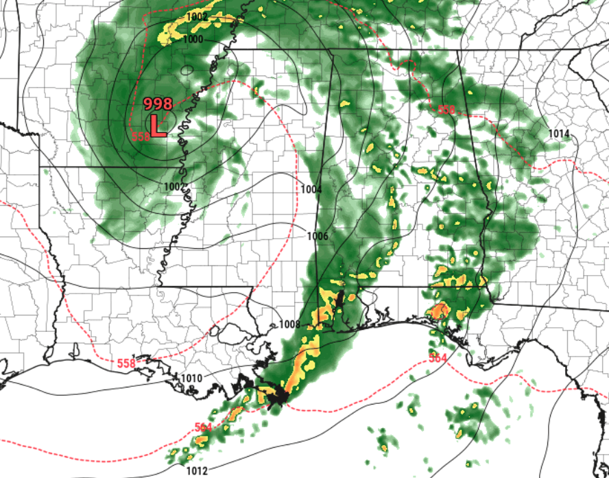
By about 2am, the line as pushed across about half of the area. And if the models are any indication, we may see a decent shove eastward across the northern sections of the line of storms.
Including pronounced bow that forms. This would indicate a risk for some stout/strong wind within these storms as they pass through your location. This may be when we see the highest risk for “severe” weather but it would be from wind and not tornadoes.
And keep in mind, a good strong wind can still be rough on trees, fences and roofs. A tree doesn’t care if the wind starts from something spinning or not — if there is a strong enough gust, it is coming down.
But that risk may be short-lived. By about sunrise, we naturally stabilize the atmosphere and these storms will lose a lot of their punch.
And by about 6a/7a these storms will me moved into Alabama, too. And we will start to dry things out for a bit.
But then as we move into the afternoon, some folks may get tapped by some light / moderate brief rain showers. These will “Feel” a bit like a Summertime storm because it’ll pop up and move through your area pretty quickly. Unlike summer storms, these may struggle to even produce a rumble of thunder.

TODAY
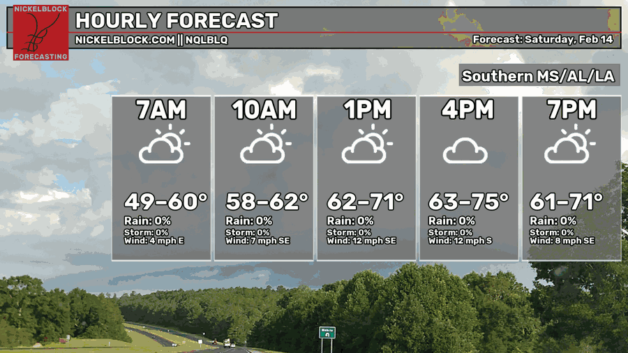
After a cool start for some folks, nearly everyone will rebound nicely today into the 60s and 70s. It will be warmer the farther south you travel. If you’re headed to New Orleans for a parade, prepare to be warm and humid.
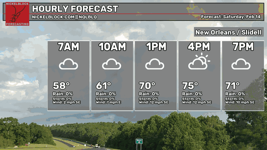
And notice everyone is dry during the day today.
TOMORROW
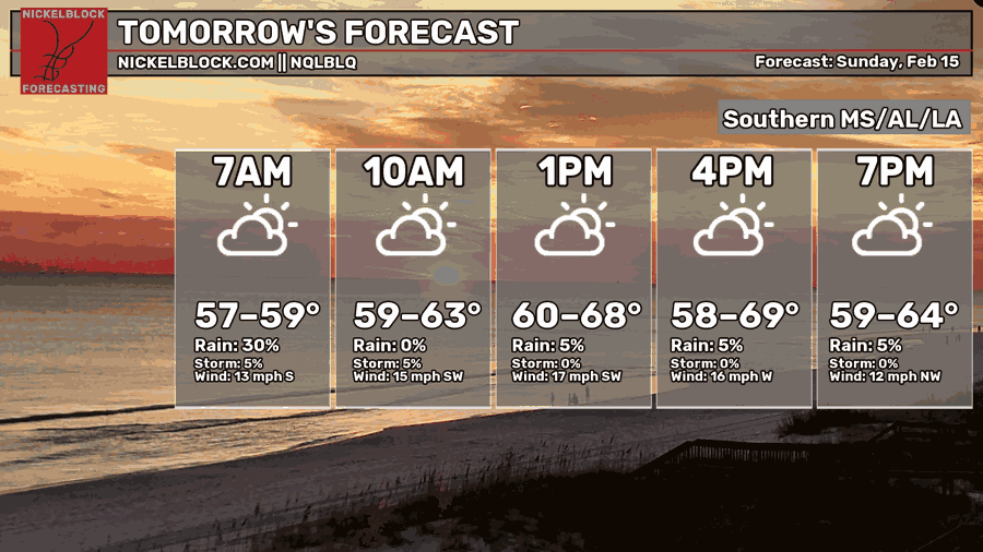
Behind all of this rain, things won’t be too much cooler. With this being more of a pacific front, we will still be hanging around in the 50s and 60s tomorrow.

15-DAY OUTLOOK
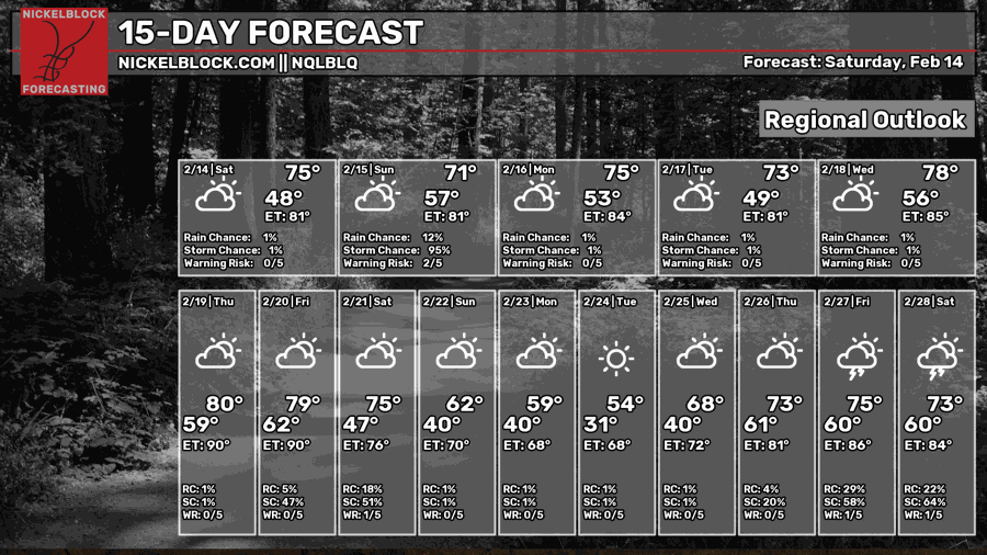
Looking at the next 15 days, there isn’t a “big cooldown” shouting at us to pay attention. I think next weekend we get another shot of cold air, but nothing too robust looks like it is headed our way. Enough to bring the plants back inside if they areout on the porch, but aside from that, things – for now – look pretty good!
BOTTOM LINE
Storms will be possible tonight and into early tomorrow morning for the area. While there is a risk for severe weather, the risk for tornadoes will be conditional. So most folks will see rain, heavy at times, wind, gusty at times, and the chance for some small hail. Only a very few set of folks have the chance to see a tornado. And, given what I’ve seen, I think up to EF-2 tornadoes will be possible, but EF-3 and EF-4s are not likely at all. And we can basically rule out EF-5s.
I know a lot of folks are wondering, “should I stay up all night for these storms?” And I don’t think that is necessary for everyone. If you have a NOAA Weather Radio and a good weather app (maybe, mine?) on your phone that is set to alert you, then head to bed, leave everything turned on, and LOUD, and head to sleep.
If anything changes, we’ll be sure to post an update!


