As the earth begins to warm, in many parts of the world, winter just doesn’t feel the same. People from New England to Scandinavia to Argentina are complaining that the winters of their childhoods, featuring weekly snow events ensuring that the ground is always caked in white from Christmastime through February, are beginning to be replaced by winters with as many rainy days as snowy days, and the ground being green more often than not.
But in the Great Lakes region, including Buffalo, the focus of this research project, it’s not so simple as warmer temperatures being equivalent to less snowfall. There’s another factor to consider, lake effect snow.
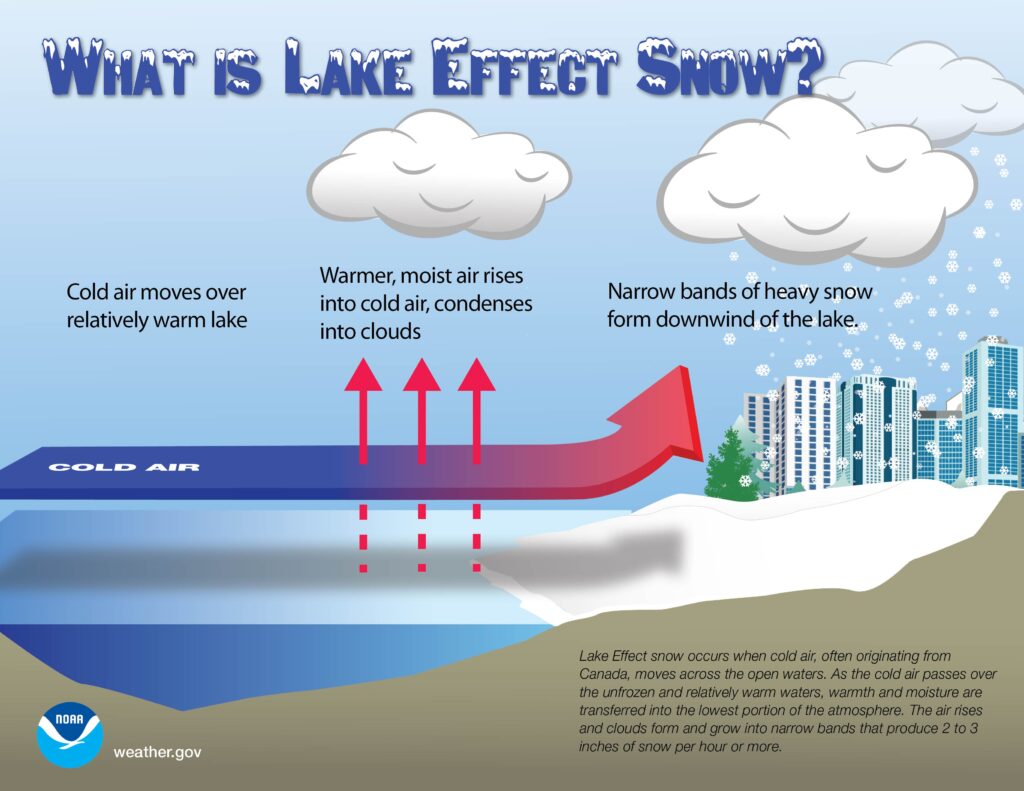
Lake effect snow requires wind blowing from lake to land. The lake must be unfrozen and relatively warm compared to the air above it. The air must also be sufficiently moist to allow clouds to form.
A critical concept to understand is specific heat. It takes around 4 times as much thermal energy to warm or cool a kilogram of water than a kilogram of air. Thinking about how this applies to nature, this means that in winter, the lake is typically warmer than the air. It takes longer to cool down and reach the freezing point.
Here’s the twist: If the air above the lake is too cold, then the lake freezes. When this occurs, it is much harder for the lake to produce lake effect snow, as the open water that fuels the process is “trapped” under the ice. It is sometimes too cold for lake effect snow.
In a place like Buffalo that is a very cold climate already, the question then becomes, could global warming actually lead to more snow? If we warm up a little bit, Lake Erie is less likely to be frozen, but it will still be under 32 degrees most of the time, creating more days in which conditions are favorable for Lake Effect snow.
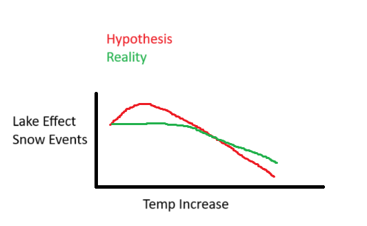
Going into this research, my hypothesis is that, until the average wintertime temperature in Buffalo reaches 32 degrees Fahrenheit, any global warming will lead to an increase in the number of lake effect snow events.
ESTABLISHING THE BASELINE
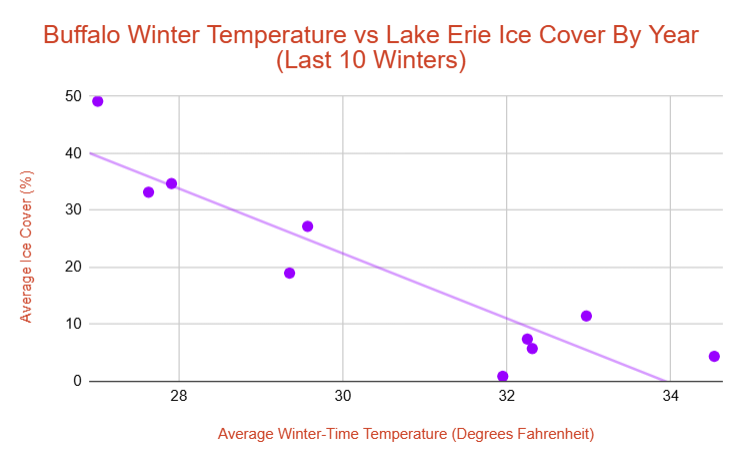
Using data from the NOAA CoastWatch Great Lakes Regional Node, and from the NWS Buffalo Weather Forecast Office, I built this graph examining the co-orelation between the average temperature in meteorological winter (defined as the whole months of December, January, and February) in Buffalo, NY, and the average percentage of Lake Erie that was frozen during meteorological winter. I did this for each of the last 10 winters.
From this, I found that over the last ten years, the average wintertime temperature in Buffalo was 30.5 degrees, and that on any given winter day, 19.3% of Lake Erie’s surface is covered. At 34 degrees, we would expect Lake Erie to have little to no ice coverage at all most of the year, as demonstrated by the line of best fit for the data above. It is a very neat data set, with data points above and below the line throughout the x-axis, none straying too far.
We also need to think about just how warm the Earth could get. A general consensus is that the worst case scenario for global warming by the year 2100 is about a 7 to 8 degree increase. To be on the safe side, I considered the possibility of a 9-degree increase for this research.
The NWS Buffalo WFO compiles an archive of lake effect snow events. There’ve been 85 total Lake Erie-influenced snow events in the past 10 years, each of which were examined in this research.
There’s two elements that must be considered here. The first: How many more lake effect events will there be due to the lake not being frozen as much. The second: How many less lake effect events will there be due to temperatures being too warm.
TEMPERATURE ELEMENT
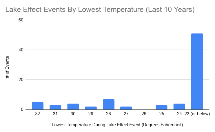
This is some pretty “noisy” data. I highly doubt, for example, that there’s a fundamental reason that no lake effect events had a low temperature of 26 degrees, but 7 events had a low temperature of 28 degrees. I don’t see any reason we can’t smooth out this data. Going forward, each degree the earth warms, 3.3 lake effect snow events per 10 years will be “lost” due to temperatures being above freezing throughout the duration of the would be snowfall.
ICE COVER ELEMENT
My methodology for this is establishing six categories for ice cover: 0%, 1-20%, 21-40%, 41-60%, 61-80%, and 81-100%. I then sorted every lake effect event into one of these six categories, based on the average Lake Erie ice cover during the event. I also measured, based on the graphs, how many total days (in the November-March period, with Oct 31 examined for non-leap years to keep an even 150 days examined per year) the lake was in each category.
A factor to keep in mind is that Lake Erie typically freezes “west to east”, as a result of the western part being more shallow. We wouldn’t expect a big impact for Buffalo if only the western portion of the lake was frozen.
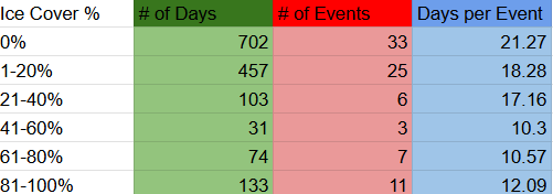
A caveat to the graph above: Every day in November has had 1% ice cover or lower in the last 10 years. If you remove November, the days per event for the 0% category drops to 17.47 days. So there isn’t a ton of difference between 0% and 1-20% operationally. Within November, there’d be one event per 30 days on average exactly based on the 10 year data set.
You’ll notice that, past 60%, the number of the days in between each event actually begins decreasing, as was expected.
Projecting difference in ice cover is a bit more difficult since it’s not directly tied to temperature, especially thinking about all of the categories above. However, a trend does emerge. Looking back at the data, winter that had an average temperature above 32 degrees ever had a period of ice cover greater than 40%. This is a statement that holds true since the data has begun to be kept, back in 2007.
CONCLUSION
The conclusion puts into question the hypothesis. Yes, the upper bounds (above 60% ice cover) are slightly less conducive for lake effect than the 40-60% range. But the frequency drops off after 40%, likely due to warmer temperatures. If you had a winter where the ice cover hovered in the 40-60% range for a long period of time, instead of spiking above 60%, then you would see more lake effect snow events. But you could also easily imagine a year where a lot of would be 40-60% days are instead below 40%, causing a decrease in lake effect snow events. And you have to remember that each degree you’re warming will cause an average of 0.33 fewer snow events per year.
And it’s pretty clear that soon after the 32 degree mark, if no part of the lake is experiencing above 40% ice cover, the warmer you get, the less lake effect events there would be.
A more likely scenario is that total lake effect events stay the same, maybe increase or decrease slightly depending on year-to-year circumstances, until you hit the 32 degree mark, at which point their frequency begin declining, just like the rest of the world. The good news is that, as shown in the second graph, a majority of Buffalo’s lake effect snow events occur in environments so far below freezing that, more than I expected. Even in a worst case scenario for climate change worldwide, Buffalo should remain a safe haven for the white flakes.
My hypothesis versus what I found could be summed up in this graph:


There’s alot of missing context here. Ice cover typically starts on the west end of the lake, because it is shallow. This does not effect take effect in buffalo. Also intensity of the lake effect is not considered. The greater the temperature variances can result in more intense snowfall. This is why all the strongest storms happen in November or early Dec when the water temp is at its warmest.
Matt,
Thank you for your input. The scope of this research project doesn’t attempt to discern snowfall totals, it more focuses on the raw number of events.
As for the lake itself freezing in the west first, that is often the case. My research does suggest that, accounting for temperature, there isn’t much difference for snow in Buffalo when the lake is anywhere below 40% frozen anyway, so you are correct, those setups wouldn’t impact lake effect in Buffalo. Another factor that effects lake effect snow is “fetch” of open water, or the total length of exposed water the wind is travelling over. That will impact things when the majority of the lake is frozen. Once you start getting above 50 or 60% ice cover, that does begin to inhibit lake effect totals and events.