The central Gulf Coast is bracing for a muggy, stormy stretch driven by tropical moisture, upper-level disturbances, and classic summertime instability. Here’s the unified outlook, along with a deeper dive into what’s fueling the weather across the Gulf Coast.
Oppressive Heat & Spotty Convection: July 29–30
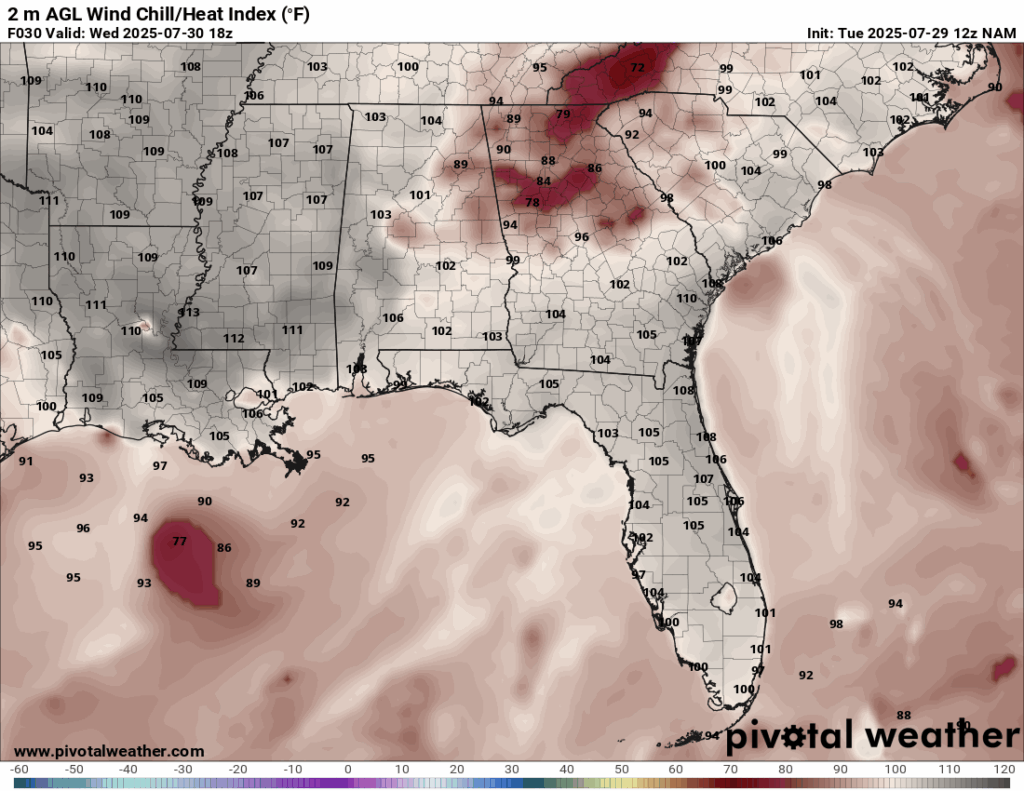
Heat index for Wednesday from the NAM model. //Courtesy: Pivotal Weather
During the first half of the week, the central Gulf Coast will endure scorching daytime temperatures ranging from 93 to 97 degrees Fahrenheit, with heat indices frequently climbing above 105°F due to extremely high humidity levels. This oppressive setup is fueled by a thick, moisture-rich air mass surging northward from the Gulf of America, saturating the lower atmosphere and causing dew points to spike into the upper 70s°F, particularly impactful in inland cities like Jackson and Birmingham, where stagnant air worsens the heat stress. The weak low-level flow contributes to minimal overnight cooling, with temperatures barely dipping below 80°F, creating sultry conditions even after sunset. Coastal zones in Louisiana and Alabama will see slightly better chances of afternoon thunderstorms, as the combination of strong solar heating and daily sea breeze fronts ignites localized convection. While rain coverage remains scattered, any developing storms could briefly drop heavy rain due to the saturated environment.
Trough Influence & Increased Rainfall: July 31–August 2
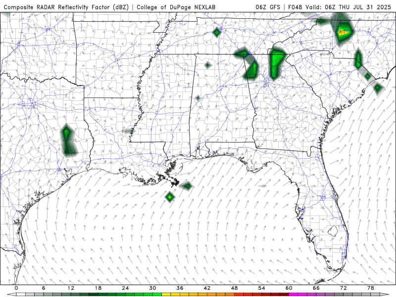
Future Radar, Thursday-Saturday from the GFS model. //Courtesy: College of DuPage
Between July 31 and August 2, a slight drop in daytime temperatures, ranging from 88 to 93°F, will offer a brief respite across parts of Louisiana, Mississippi, and Alabama, thanks to increased cloud cover and widespread rainfall. The primary driver of this pattern is a shortwave trough dipping into the Deep South, which boosts upper-level lift and sets the stage for enhanced convective activity. Moisture is pooling along the trough’s axis, saturating the atmosphere and leading to better storm organization, particularly in central Mississippi and Alabama, where broad rain coverage is expected. This setup also amplifies atmospheric instability, allowing thunderstorms to build more rapidly and sustain longer durations. Some areas may see locally heavy rainfall totals between 0.5 and 1 inch, potentially resulting in minor flooding, especially in urban or low-lying areas with poor drainage.
Return to Stability & Subtle Warming: August 3–5
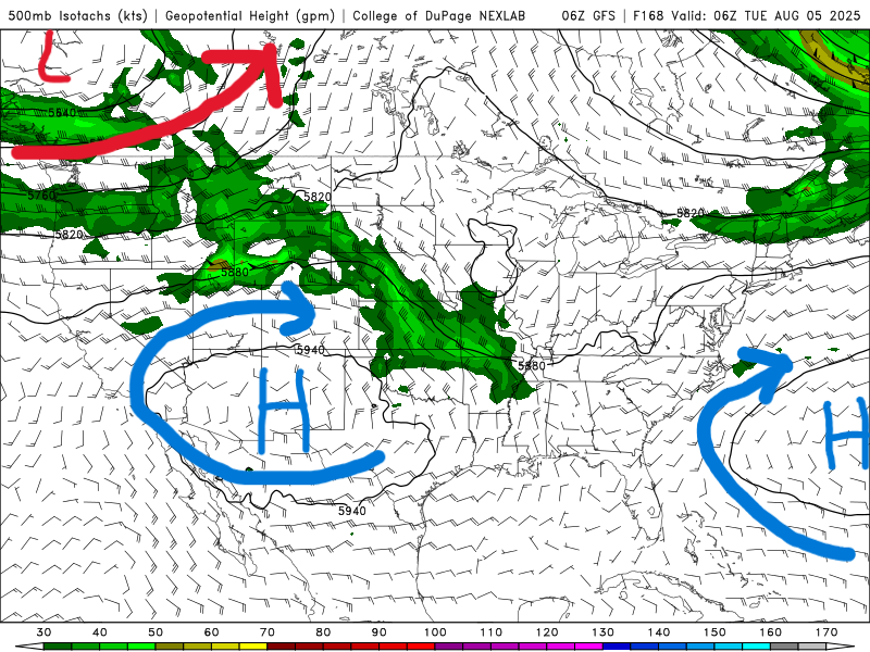
500 mb map for next Tuesday from the GFS model. //Courtesy: College of DuPage
As the Bermuda High strengthens its grip over the southeastern United States, a notable return to warmer conditions is expected, with afternoon highs climbing into the low 90s. This dominant high-pressure system promotes atmospheric subsidence, which suppresses cloud formation and results in clearer skies across much of the region. With less cloud cover, solar heating intensifies, although slightly reduced dew points, dropping into the mid-70s rather than the upper-70s, may offer some marginal relief from the muggy conditions. Rain chances taper, with any showers or thunderstorms being mostly isolated and short-lived. Surface heating combined with lingering humidity may still trigger pockets of convection, particularly near coastal zones where moisture remains more abundant. Overall, the pattern reflects a more stable and summery setup, albeit with a few fleeting bursts of activity.
Regional Day-to-Day Forecast
Tonight (Thursday Night) – Spotty showers tapering off across Louisiana and southern Mississippi. Skies turning partly cloudy overnight. Lows range from 74–79°F with light southeast winds.
Friday – Continued chance of showers and a few thunderstorms across Louisiana and central Mississippi. Alabama sees more sunshine, with only isolated convection in coastal areas. Highs near 87–91°F. Heat index values reach 100–104°F. South winds 5 to 10 mph.
Friday Night – Partly cloudy with patchy fog possible inland. Lows around 74–81°F. Winds light and variable.
Saturday – Drier and sunnier as the Bermuda High intensifies. Only a 10–20% chance of a pop-up coastal storm. Highs climb to 91–94°F. Heat indices 102–106°F. South to southwest winds 5–15 mph.
Saturday Night – Mostly clear skies with warm, muggy conditions. Lows from 75–80°F. Winds remain light.
Sunday – Sun-drenched skies dominate the day. An isolated afternoon shower possible near Gulf-facing coasts. Highs 92–95°F. Heat index values 104–108°F. Winds southerly at 10 mph.
Sunday Night – Calm and clear. Lows hold near 75–81°F. A slight breeze from the south.
Monday – A weak front stalls north of the region, increasing cloud cover slightly. Spotty afternoon showers possible in Mississippi. Highs near 90–93°F. Winds southwest at 5–10 mph.
Monday Night – Mostly cloudy with a 20% chance of scattered overnight showers. Lows steady near 76–80°F. Winds light.
Tuesday – Increased cloudiness with widely scattered showers. Best rain chances (30%) in Mississippi. Temperatures moderate slightly: highs 88–92°F. South winds 5–10 mph.
Tuesday Night – Partly cloudy with occasional light rain. Lows 74–79°F. Winds light and variable.


