Hurricane Flossie is making its way up the coast of Mexico, with heavy rain and tropical storm force winds to impact parts of Mexico. Crowding Flossie is another disturbance off the coast of Southwest Mexico. There is also an Atlantic disturbance spanning some of the Gulf, Florida, and the coasts of Georgia and the Carolinas. Let’s take a closer look at each tropical event:
Hurricane Flossie:
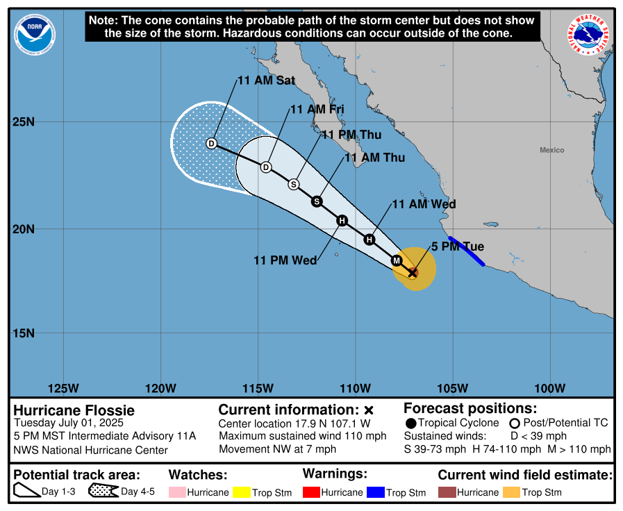
As of Tuesday afternoon, Hurricane Flossie reached Category 2 status. As of Tuesday evening, Flossie was just on the brink of Category 3 status, with maximum sustained winds at 110 mph. (Note that the threshold for a Category 3 storm on the Saffir-Simpson Scale is maximum sustained winds of 111 mph.) Flossie is moving Northwest at about 7 mph, and has a minimum central pressure of 966 mb. While Flossie is not forecasted to make direct landfall on Mexico, it effects will still have an impact on land.
Likely Impacts from Flossie:

One of the main effects from Flossie will be tropical storm force winds blowing onto land. These strong winds will most likely impact parts of the coast of Jalisco, just south of Puerto Vallarta, early this morning. By this evening and into the early morning on Thursday, tropical storm force winds may impact much of Baja California Sur, including Cabo San Lucas. These winds can be damaging to those in the area and their property.
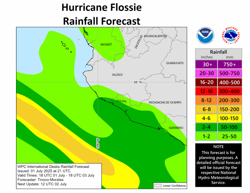
Precipitation from Flossie will also impact parts of Nayarit, Jalisco, Colima, Michoacan de Ocampo, and Guerrero throughout the day today, with rainfall amounting up to 4 inches, but may be more in localized areas. By Thursday morning, rainfall from Flossie will likely affect much of Baja California Sur and then make its way onto mainland Mexico:

Heavy rainfall on land may cause flooding and even mudslides in steeper terrain, so being prepared for heavy rainfall is crucial for those in the impacted areas.
Another Disturbance on the Way

There is yet again another disturbance off the coast of Southwestern Mexico, following Flossie while it moves west-northwestward. This disturbance has a 40% chance of developing into a tropical cyclone of some sort, at this point most likely a tropical depression, within the next week. The National Hurricane Center has forecasted a low pressure area to develop in the disturbance’s region, and environmental conditions are currently supporting its development. The current combination of warm sea surface temperatures and high relative humidity will help push this disturbance’s development in the next couple of days, although there are patches of high wind shear in the disturbance’s area that may deter the disturbance a bit.
Disturbance in the Atlantic
Here’s the current setup in the Atlantic:
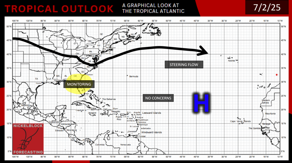
There is still high pressure spanning much of the Atlantic Basin, but there is still an area of concern over by Florida. Let’s take a closer look:
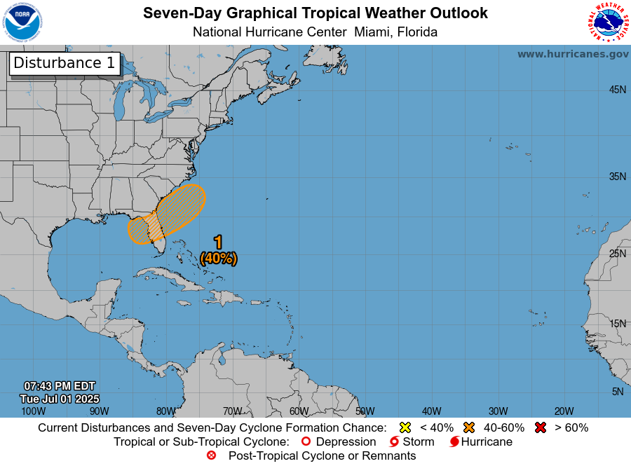
This area has a 40% chance of development in the next week, as a low pressure are may form along the current cold front that exists over the East Coast. Although, this front is weakening, and this disturbance will most likely only develop into some sort of depression, and it is not forecasted to move very much. So, the main effects from this disturbance will be some heavy rainfall in the Southeast, particularly over Central Florida. If you are currently in Florida, definitely keep an eye out for heavy rainfall, and stay tuned to NickelBlock for more tropical updates!


