General Central/Eastern Kansas Forecast
Short-Term (Friday-Saturday)
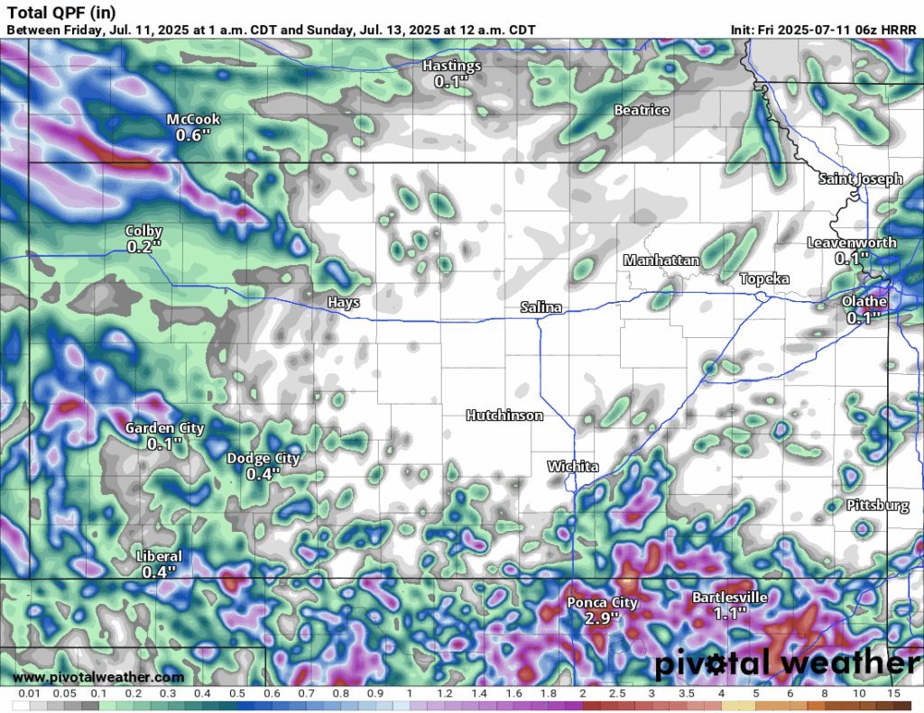
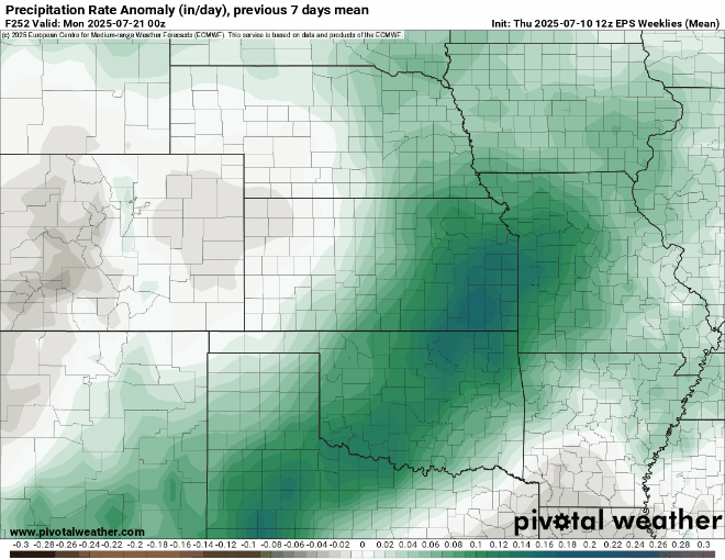
A cold front is expected to make its way through the state this afternoon and this evening, which may help increase rain chances somewhat across the region, particularly in eastern Kansas. Isolated to scattered thunderstorms (increasing in coverage the further east you go) will be possible this evening after 4pm and lasting into the overnight hours, gradually shifting south with the advancing cold front. The main area of focus for these storms will be along and east of US-75, with more isolated development east of US-77. Some severe winds may be possible, as well as locally heavy rainfall (although new rain totals are expected to be below an inch from these storms).


As the cold front keeps pushing south overnight, any thunderstorm activity will be confined to southeast Kansas through the early morning hours tomorrow. These storms will mostly be sub severe by this point, although a chance for some gusty winds may still be evident. This activity will then die off by sunrise tomorrow and drier air will move in over the state during the day. Depending on how far south this cold front decides to stall out and as another upper-level disturbance passes over us, more isolated to scattered showers and thunderstorms are possible in the afternoon and evening hours. This is far from a guarantee though, but if anyone does see any rainfall tomorrow afternoon/evening, it will mostly be confined to south and east of I-35. Another cold front will also move its way in from the northwest and will dry us out even more for Sunday.
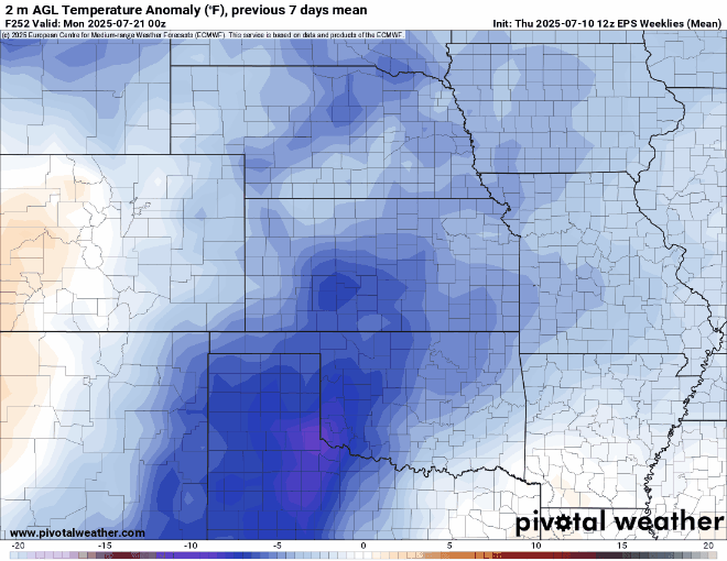
Temperatures throughout the day today will again be in the low to mid 90s, with southwesterly winds at 10 to 15 mph, becoming more northerly by this afternoon and evening as the cold front passes. Heat indices will again reach the mid to upper 90s today (higher values generally the further east you go) with our relative humidity being between 40-60%. Overnight, low temperatures behind the front will drop down into the low to mid 70s. By tomorrow, temperatures will be slightly cooler (in the upper 80s to low 90s) and conditions slightly drier as the cold front completely passes through. Winds will generally be northerly at 5 to 10 mph throughout the day. Overall relative humidity will be higher than today, with values between 45-65%, making for possibly a slightly more humid day even with the reduced temperatures.
Long-Term (Sunday-Thursday)
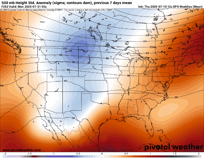
As another cold front passes on Sunday, conditions will really dry out throughout the day and drop our precipitation chances. Moisture return should begin by Monday, and underneath weak quasi-zonal flow aloft through the week next week, daily chances for isolated showers and thunderstorms will return to the region. This pattern will last until mid-next week or so, to which then some signs of a cold front will pass through by the Wednesday-Thursday timeframe. Exact details are still murky at this time but generally, rain chances may increase as this front passes through. Temperatures from Sunday will be cooler in the upper 80s and will more or less hover between the upper 80s to low 90s through the majority of the week next week.
Drought Update
Abnormally dry conditions have now developed across portions of eastern Kansas between last week and this week (in areas within Osage, Shawnee, Franklin, Douglass, Johnson, and Miami counties) due to the lack of consistent appreciable rainfall. Even with the somewhat increased rain potential going forward, further areas may see abnormally dry soil conditions develop by next week due to the lack of widespread consistent rainfall. Even with this in mind, most of the region is still in relatively good shape, with much of the southern tier of Kansas still drought free.


Seasonal Climate Update
Long-range guidance maintains a varied pattern between incoming disturbances and high pressure replacing each other back and forth before high pressure tries to set in for good heading into August. This in turn would see us increasing in temperature and decreasing overall consistent rainfall potential (as is usual for this time of year). More widespread drought conditions may then develop over this period, but relative severity looks to be on the lower side for now with only slightly above average temperatures and slightly below average rainfall expected.
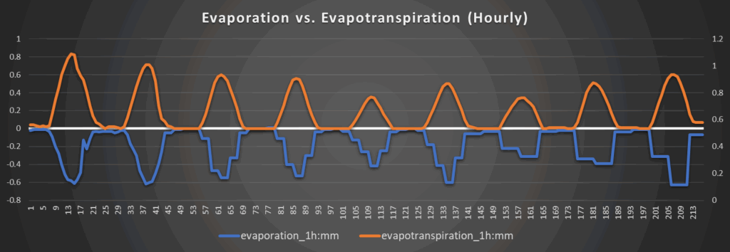
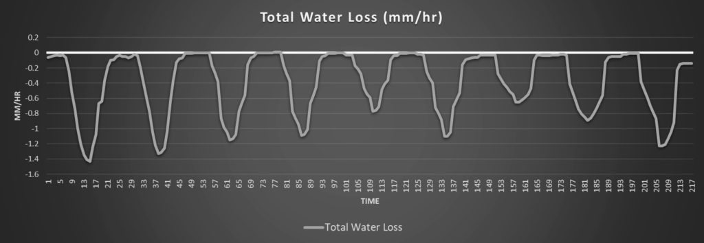
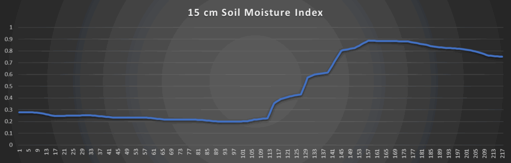
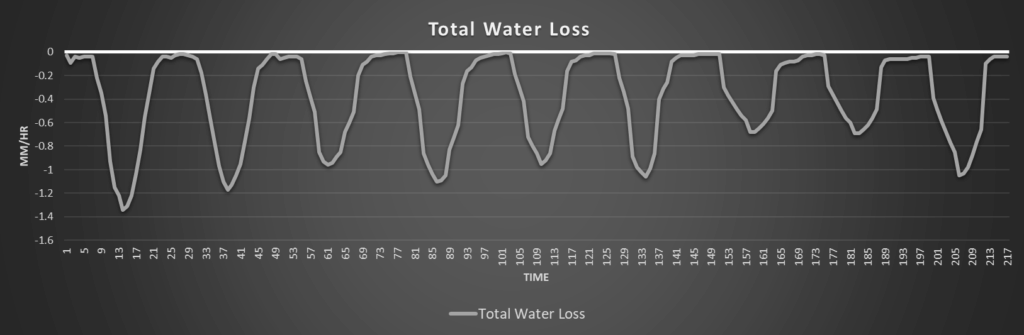
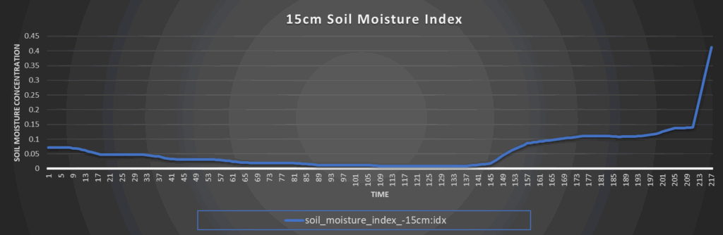
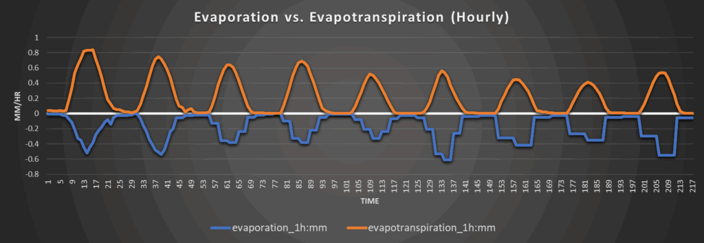
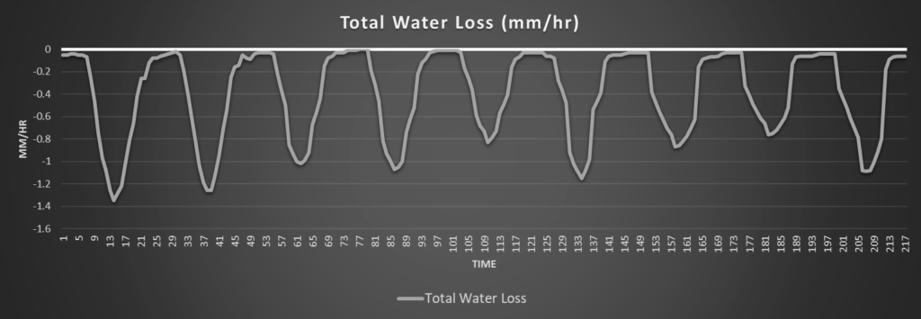
Regional Soil Moisture Outlook
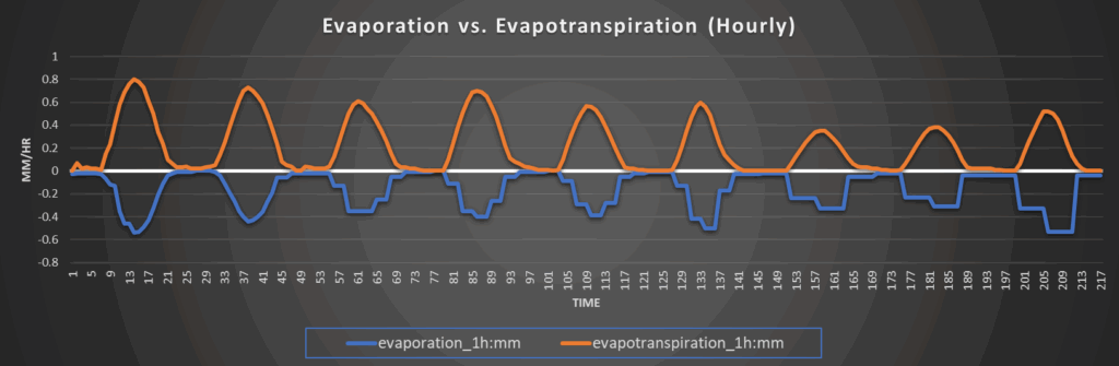
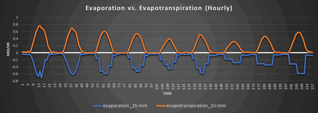
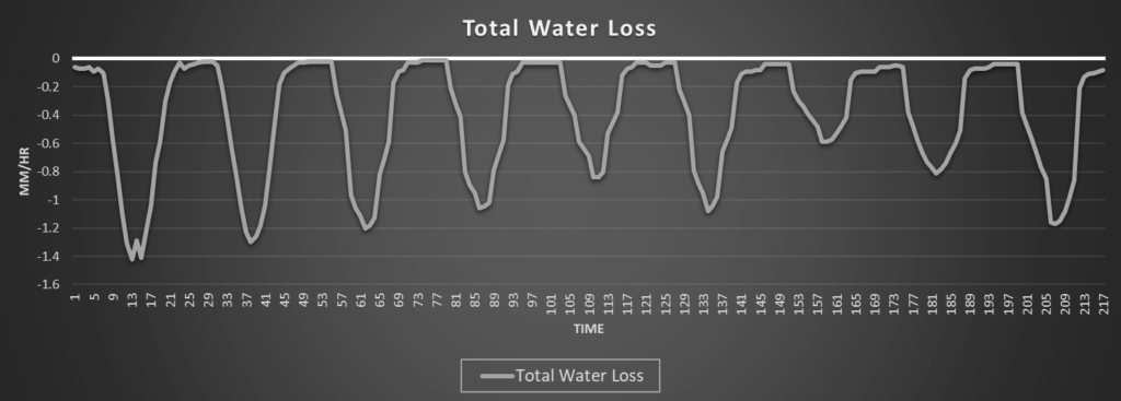
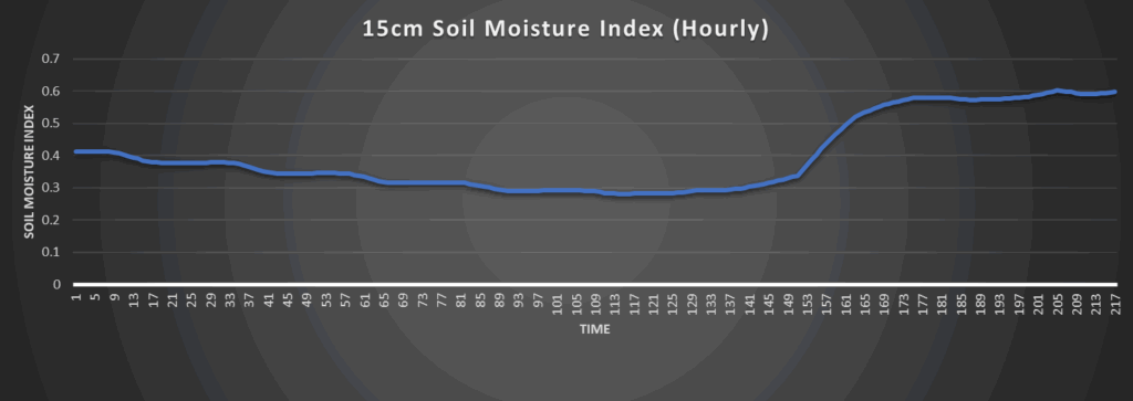
Soils across the region will continue to consistently dry, even with the rainfall chances over the next few days. This will help cause some more abnormally dry conditions to develop across more areas of central to eastern Kansas, although water loss rates will be relatively modest (between 1 to 1.3 mm/hr after today) over the next week. Models continue to hint at soil moisture replenishment in the long-range (possibly from this incoming potential cold front), but overall confidence is low in this, so it remains to be seen if this can be realized or not.
Around Westmoreland
Around Scranton
Around Burlington
Around Altoona