I know a lot of times we, meteorologists, toss around freezing rain, sleet, and snow and never really take the time to define the difference. So today, I wanted to take “Five” so to speak and break down the difference between the three types of wintry precip.
And I want to start with this graphic from the NWS.
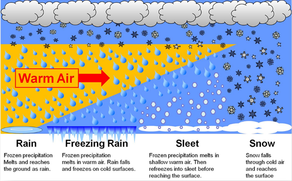
The key thing to understand is that almost all precipitation in winter starts as some sort of frozen water. In many cases, it begins as ice crystals more than 10,000 feet above the ground. When conditions are right, those ice crystals grow and cluster together into dendrites… the classic branching structure we associate with snowflakes.
If the temperature stays at or below freezing from that point all the way down to the surface, those snowflakes never melt. For example, if the temperature profile from cloud level to the surface is below freezing (say the surface temperature is around 30F) then you’re going to get snow.
Things get more complicated when there’s a layer of warmer air (with a temperature above freezing) somewhere between the cloud and the ground. Meteorologists often call this a warm nose. If that warm layer is warm enough and thick enough, it can melt falling snowflakes, turning them back into liquid raindrops before they reach the surface.
What happens next depends on how deep the cold air is near the ground.
SLEET
Sleet occurs when that warm layer is relatively thin, like, only a few thousand feet thick. In this case, the snow melts into a raindrop as it falls through the warm layer, but then passes into a deeper layer of subfreezing air closer to the ground. That cold air gives the raindrop enough time to refreeze before it hits the surface. The result is sleet: small, hard ice pellets.
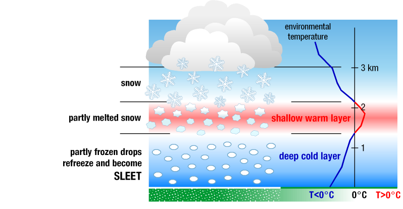
Sleet is sometimes described as “tiny hail,” but it forms very differently. Hail grows inside thunderstorms through repeated trips up and down within strong updrafts. Sleet, on the other hand, is simply a snowflake that melted and then refroze on its way down.

FREEZING RAIN
Freezing rain is different. It happens when the warm layer aloft is much thicker. In this case, thick enough that snow completely melts into rain… plus the cold air near the surface is shallow. In this setup, the raindrop doesn’t have enough time to refreeze before reaching the ground. Instead, it remains liquid all the way down, even though surface temperatures are at or below freezing.
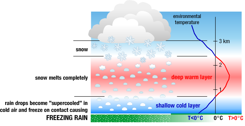
Another – very cool- thing that can happen is that supercooled raindrops can fall. These are rain drops that have a temperature that is below freezing… but are still liquid. This often happens when the temperature outside is well-below the freezing mark. In this case, the supercooled liquid raindrop hits the ground and freezes on contact. That’s what creates the glaze of ice on roads, trees, power lines, and sidewalks that makes freezing rain so dangerous.
Measuring freezing rain accumulation isn’t as easy as looking in a rain gauge. Instead it takes a regular old ruler.
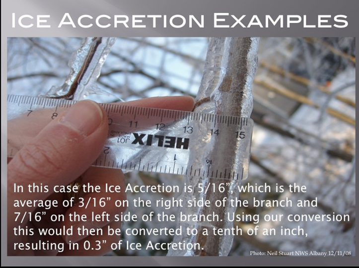
Often the easiest way is to take the average value of the ice accretion on each side of a tree branch.
SLEET & FREEZING RAIN SAFETY
While sleet and freezing rain can look similar on radar (and even fall from the same storm system) their impacts on the ground can be very different. Understanding those differences helps explain why some winter storms mainly cause travel issues, while others can lead to widespread damage.
Sleet is really a road hazard first… everything else comes second.
Because sleet falls as small, hard ice pellets, it tends to bounce when it hits the ground. It can accumulate, sometimes quickly, but it generally doesn’t bond to every surface the way freezing rain does. That said, sleet can still be extremely dangerous for travel.
When sleet piles up on roads, it acts like a layer of ball bearings. Tires struggle to grip the surface, braking becomes meaningless, and even treated roads can remain slick. Sleet accumulation is especially hazardous on bridges, overpasses, and elevated roadways, where surfaces cool more quickly.
The good news is that sleet typically does not cling efficiently to trees and power lines. Because it doesn’t coat surfaces with a smooth glaze, sleet events don’t cause as many power outages or as much tree damage.
Freezing rain is often the most dangerous form of winter precipitation.
Unlike sleet, freezing rain creates a smooth, heavy coating of ice on everything it touches… be it roads, sidewalks, trees, power lines, vehicles, and buildings.
On roadways, freezing rain can turn pavement into near-glass, even with light amounts of precipitation. Unlike sleet or snow, freezing rain is extremely difficult to plow or treat effectively once it begins accumulating.
The larger danger, however, comes from ice accretion on trees and power lines. As ice builds up, the added weight can cause branches to snap and power lines to sag or fail. This is why freezing rain events are so often associated with:
— Widespread power outages
— Downed trees and limbs
— Extended recovery times, even after precipitation ends
Unlike sleet events, freezing rain storms can impact entire communities for days, not just hours.
That is why a few hours of freezing rain can be worse than an entire day of sleet. And why forecasting precipitation type becomes so very important.
FORECASTING SLEET VS FREEZING RAIN
When you look at these two graphics side-by-side you can get an idea about why it can be difficult to forecast one versus the other. And why weather models struggle to assign a value to ice accretion and sleet totals.
The difference between getting sleet compared to freezing rain – and vice-versa – can be as small as a few hundred feet of warmer-than expected air aloft, or a few hundred feet of colder than expected air toward the surface.
That’s also why winter forecasts can change up to and even during an event. A subtle shift in temperature aloft, a slightly stronger push of warm air (or colder air) closer to the ground can flip the outcome from sleet to freezing rain… or the other way around. When the atmosphere is balanced on that sharp of an edge, small errors in a forecast or changes at the last minute can have big consequences.
It’s also why you’ll often see us focus less on exact sleet or ice totals and more on impacts and timing. When precipitation type hinges on such a narrow margin, communicating risk matters more than locking in a precise number.


