Intriguing data this afternoon from the HRRR model. It shows two big things for snow-lovers on Wednesday morning between about 4a and 8a: We will be building (a lot) of snowflakes up around 18,000ft (blue circle area on the graph below) and the atmosphere from about 2,000ft to 8,000ft will be dry enough (purple circle below) that if it becomes saturated by precipitation, would cool down enough to allow snowflakes to get pretty close to the surface.

The question remains, a bit like trying to figure out what a catch is in the NFL, with the snowflakes survive the fall to the ground? And if so, how long does that last?
QUICK DETAILS
And, you guys know me, when it comes to wintry precip as close as we are to the Gulf of Mexico, I tend to be pretty conservative with my forecasts. So my guess is that the chance you see any snow mixing in is still not terribly high. But I think it is higher today than it was yesterday.
So here is a look at how the data today shakes out:
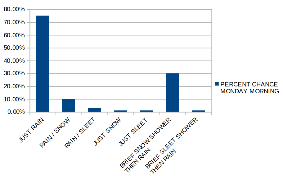
Seeing “just rain” is still the most likely scenario for a lot of folks. And it will be a pretty cold rain, too. Temperatures on Wednesday morning look to be hovering between 37F and 41F. But the next most likely situation is a brief shot of some snow showers, then just rain. And that brief shot of snow may be in some of the heavier showers. And it may be a full change-over for 10 to 15 minutes before going back to rain.
You may say, “wait a second, those don’t all add up to 100%, Nick!”
You’re right! They don’t. Partly because weather is weird like that and partly because that is trying to forecast for the entire region. And want to make sure that it is applicable for everyone. And, as many of you know, the weather in St. Tammany Parish can be drastically different than Clarke County on the same day at the same time. In order to reflect that, the graph can’t really equal 100.
It still looks like the data supports the best chance for a wintry mix is north of Highway 98, but I don’t think we can completely rule it out south of there, too.

LOCAL IMPACTS
Aside from looking pretty cool, I don’t think there will be much of an impact. Temperatures will remain above freezing throughout and any change-over to snow looks to be pretty brief. Schools, businesses, roads, and everything else (given the available data) should be unaffected. That said, there may be delays in “life” as we all stop to look out the window should things change to snow for a few minutes.
Once the late night / overnight data comes out, I’ll be sure to post an update in the morning!


