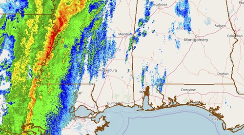
The line of storms continues to approach from the west. Latest model guidance shows the line should hold together – mostly – as it works through the area. The wind fom the south ahead of the line of storms will continue to be gusty. Sustained wind of 25mph with gusts to of more than 35mph have been recorded this morning.
Quick Forecast
As the line passes, wind will flip back to the Northwest and then to the West. Heavy rain, wind gusts to 70mph, and a tornado or two will be possible. As the front approaches there will be a chance for discrete supercells to develop ahead of the line, but that is looking less likely.
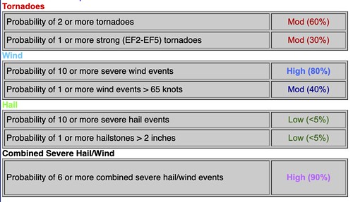
Based on the Tornado Watch currently in effect to the west, the following probabilities will likely hold for South Mississippi, too.
Some Notable Data
1 – The Updraft Helicity streaks have come back a bit more pronounced this morning. On the data, the numbers aren’t terribly high – which should limit the threat for stronger tornadoes – but the entire area looks to have numbers on the low-end of the scale. That means as the line moves through the area there may be a slightly higher risk for brief and weak tornadoes along the leading edge of the line of storms. It may also be the model picking up on embedded supercells, too.
2 – LCL heights will remain rather low given the incredible moisture surging north out of the Gulf. That will mean that any tornado that does form – even if in daylight – won’t likely be able to be seen. So when a Tornado Warning is issued, try to resist the urge to look outside to see it, because even if it was outside your window, it is unlikely you would see it.
3 – Looking at the Mesoanalysis page from the SPC, shear will be decreasing (slightly) during the next few hours while instability will be increasing (slightly). We will have to see how that impacts storm mode and threats. This isn’t a “surprise” in the data, but a bit earlier this morning and late last night, there was some discussion about the environment being “over-sheared” with not enough instability. And that was leading to a lack of organization within the storms.
What has changed with the forecast?
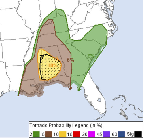
Not much, really. Still looking like a line of storms moving through. Straight-line wind is still the main concern. And we still can’t rule out a tornado. That said, the Storm Prediction Center just issued an update on today’s Severe Weather Risk and only made a few changes.
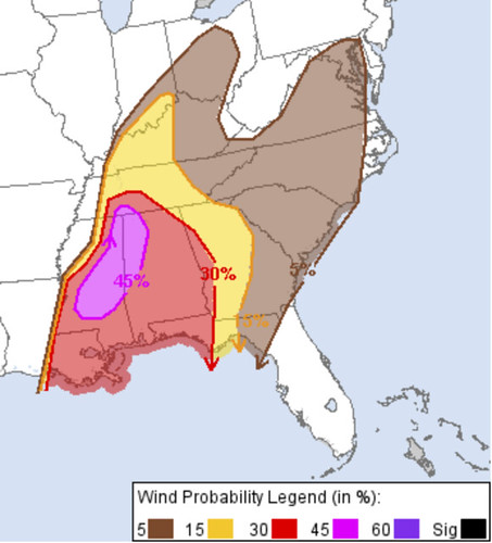
They increased the wind risk for our NW counties. You may have seen me on TV last night noting that area with a higher risk for some of the stronger storms.
The SPC also increased the tornado risk in our eastern counties and into Alabama.
This is likely due to the timing and the storms moving through with the daytime heat. It may also be a funciton of the latest data showing that slight decrease in shear and increase in instability.
So, for south Mississippi, while it may be tough to make out specifically on those maps, the SPC just increased the tornado risk for later this morning across Wayne, Greene, Perry, and George counties – as well as east into Alabama. And increased the straight-line wind threat for Lawrence, Jeff Davis, Covington, Jones, Jasper, Smith and Simpson counties.


