The National Hurricane Center analysis of Hurricane Zeta during the past few months has led them to the conclusion that Hurricane Zeta was – in fact – a Major Hurricane at landfall.

In a complete breakdown, released on May 10th, the NHC showed that through reanalysis of satellite data, radar data, and radiosonde data, the Hurricane had wind at 110kts at landfall.
NHC post-season brief discussion
The NHC produced a 56-page report documenting all of the data that went into their decision to ‘up’ Hurricane Zeta to a Major Hurricane at landfall
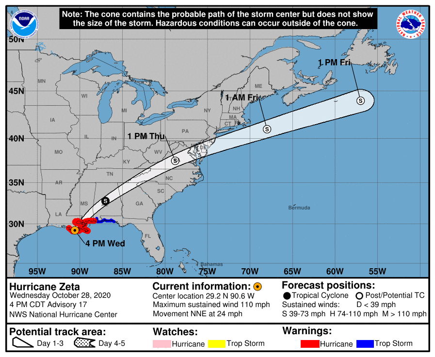
The synoptic pattern was changing rapidly ahead of Zeta as a deep-layer cutoff low over the southwestern United States moved eastward. This low caused the ridge over the Gulf of Mexico to erode from the west, and the tropical cyclone moved northwestward on 27 October across the southern Gulf of Mexico. Zeta maintained its strength that day while it recovered from land interaction, but began to re-intensify the next day in a conducive environment of low shear and warm SSTs—an uncommon combination for so late in the year in the southern Gulf of Mexico.
Zeta became a hurricane again early on 28 October while it turned northward and moved faster over the south-central Gulf of Mexico. The cutoff low reached west Texas that day, and the fast flow between the low and the retreating ridge located near Florida caused Zeta to accelerate north-northeastward. This pattern also likely provided a favorable divergent upper-level environment for strengthening, and Zeta rapidly intensified while it moved quickly (with a forward speed of 20–25 kt) toward the Louisiana coast.
Radar and reconnaissance data indicate that Zeta made landfall near Cocodrie, Louisiana at around 2100 UTC 28 October with an intensity of 100 kt and a minimum central pressure of 970 mb.
The hurricane’s eye moved directly over New Orleans a couple of hours after landfall, with the center crossing into southern Mississippi that night and moving across southwestern Alabama early the next day, bringing strong winds well inland. Zeta weakened to a tropical storm just south of Tuscaloosa, Alabama early on 29 October and then raced northeastward across northern Georgia and the southern Appalachian Mountains.
The storm transitioned into a post-tropical cyclone over central Virginia by 1800 UTC that day, and continued moving rapidly northeastward. Zeta became entwined with a frontal zone early on 30 October and then dissipated over the western Atlantic Ocean a couple of hundred miles east of Atlantic City, New Jersey.
Courtesy: nhc.noaa.gov
Recall that originally, the NHC only had wind speed at 95kts at landfall.
This reanalysis data shows it had wind speeds up to 15mph faster than indicated on the graphic above.
Local Impacts
You may recall that Hurricane Zeta was really bookin’ and cruised across the area in a matter of a few hours. Local tropical expert, Dr. Kim Wood, up at Mississippi State University was relfecting on the speed of Zeta last month when doing her own reanalysis.
The forward speed of the tropical system likely aided some of the ground truth wind speeds. A section of South Mississippi was hammered by Zeta wind and and rainfall. The NWS in Mobile Alabama is still collecting and surveying the data (usually they are much faster, but there were so many hurricanes last year, it is taking longer than usual) but the NWS Office has tallied some of the rainfall totals
STORM TOTAL RAINFALL FROM 0000 UTC OCT 29 UNTIL 0000 UTC OCT 29 —-
CITY/TOWN COUNTY ID RAINFALL LAT LON (IN) DEG DECIMAL —-
2 W WAYNESBORO WAYNE COOP 6.25 31.68 -88.67
BLACK CREEK PERRY BLCM6 5.16 30.85 -89.03
LEAKESVILLE GREENE CHILI 4.85 31.18 -88.60
WAUSAU WAYNE LAUM6 4.73 31.52 -88.89
2 NW NEW AUGUSTA PERRY NAGM6 4.51 31.22 -89.05
2 NE PERKINSTON STONE MS-ST-4 3.84
Courtesy: Weather.gov
Here is a look at some of the NWS storm reports… (swipe to side for extra information)
G. STORM IMPACTS BY COUNTY...
---------------------------------------------------------------------
COUNTY            DEATHS           INJURIES             EVACUATIONS
DESCRIPTION
---------------------------------------------------------------------
STONE                0                 0                     0

SUSTAINED STRONG TROPICAL STORM FORCE WINDS WITH GUSTS TO HURRICANE
FORCE RESULTED IN SIGNIFICANT TREE AND POWER LINE DAMAGE. NUMEROUS
TO WIDESPREAD POWER OUTAGES WERE REPORTED. 170 HOMES WERE DAMAGED,
EXPERIENCING EITHER ROOF DAMAGE OR DAMAGE DUE TO DOWNED TREES WITH
15 OF THE HOMES EXPERIENCING MAJOR DAMAGE.

GEORGE               0                 1                     0

SUSTAINED STRONG TROPICAL STORM FORCE WINDS WITH FREQUENT GUSTS OF
80-100 MPH RESULTED IN WIDESPREAD TREE AND POWER LINE DAMAGE
THROUGHOUT THE COUNTY. POWER OUTAGES WERE NEAR OR AT 100%. NUMEROUS
HOMES SUFFERED DAMAGE, MAINLY TO ROOFS. APPROXIMATELY 100 HOMES HAD
MAJOR DAMAGE WITH 30 DESTROYED, DUE PRIMARILY TO DOWNED TREES. THERE
WAS ONE MINOR INJURY AS AN INDIVIDUAL WAS IN A CAR ACCIDENT WHILE
TRYING TO DRIVE TO WORK DURING THE STORM.

PERRY                0                 0                     0

SUSTAINED STRONG TROPICAL STORM FORCE WINDS WITH GUSTS TO HURRICANE
FORCE RESULTED IN SIGNIFICANT TREE AND POWER LINE DAMAGE. NUMEROUS
TO WIDESPREAD POWER OUTAGES WERE REPORTED. 36 HOMES WERE DAMAGED,
EXPERIENCING EITHER ROOF DAMAGE OR DAMAGE DUE TO DOWNED TREES.

GREENE               0                 0                     0

SUSTAINED STRONG TROPICAL STORM FORCE WINDS WITH FREQUENT GUSTS OF
80-100 MPH RESULTED IN WIDESPREAD TREE AND POWER LINE DAMAGE
THROUGHOUT THE COUNTY. POWER OUTAGES WERE NEAR OR AT 100%. NUMEROUS
HOMES SUFFERED DAMAGE, MAINLY TO ROOFS. APPROXIMATELY 30 HOMES HAD
MAJOR DAMAGE WITH 7 DESTROYED, DUE PRIMARILY TO DOWNED TREES.

WAYNE                0                 0                     0

SUSTAINED TROPICAL STORM FORCE WINDS RESULTED IN SIGNIFICANT TREE
AND POWER LINE DAMAGE. NUMEROUS POWER OUTAGES WERE REPORTED. 13
HOMES WERE DAMAGED, EXPERIENCING EITHER ROOF DAMAGE OR DAMAGE DUE TO
DOWNED TREES.
| Office | Report Time (Local WFO Timezone) | County | Location | ST | Event Type | Source | Remark |
| MOB | 2020/10/28 19:11 | PERRY | 3 WNW MCLAIN | MS | HURRICANE | EMERGENCY MNGR | TREES AND POWER LINES DOWN IN EASTERN PERRY COUNTY, MS.. |
| MOB | 2020/10/28 20:30 | STONE | 2 WSW PERRY | MS | HURRICANE | PUBLIC | NUMEROUS TREES DOWN IN THE MCHENRY COMMUNITY. |
| MOB | 2020/10/28 20:30 | STONE | WIGGINS | MS | HURRICANE | PUBLIC | NUMEROUS TREES AND POWER LINES DOWN ALL ACROSS THE WIGGINS AREA. |
| MOB | 2020/10/28 20:59 | PERRY | 7 SE JANICE | MS | HURRICANE | FIRE DEPT/RESCUE | WIDESPREAD TREE DAMAGE IN SOUTHERN PERRY COUNTY, MS. |
| MOB | 2020/10/28 21:17 | PERRY | JANICE | MS | HURRICANE | EMERGENCY MNGR | TREES DOWN ON MOBILE HOME AND SHED IN JANICE COMMUNITY IN PERRY COUNTY. MODERATE TREE AND POWER LINE DAMAGE.. |
| MOB | 2020/10/28 21:25 | PERRY | 2 NNE WINGATE | MS | HURRICANE | EMERGENCY MNGR | TREE ON HOME IN NEW AUGUSTA, MS OFF RIVER LOT RD. |
| MOB | 2020/10/28 21:29 | PERRY | BEAUMONT | MS | HURRICANE | EMERGENCY MNGR | TREES DOWN, DESTROYING HOMES IN BEAUMONT, MS. |
| MOB | 2020/10/28 21:41 | GREENE | 3 NW LEAKESVILLE | MS | HURRICANE | MESONET | MESONET STATION IN LEAKSVILLE, MS GUSTED TO 69 MPH DURING HURRICANE ZETA. |
| MOB | 2020/10/28 22:00 | WAYNE | 1 NNE ROBINSON JUNCTION | MS | HURRICANE | EMERGENCY MNGR | MOBILE HOME PARK LOCATED OFF OF HWY 45 WITH ROOFS TORN OFF OF HOMES. |
| MOB | 2020/10/28 22:00 | WAYNE | STATE LINE | MS | HURRICANE | EMERGENCY MNGR | MULTIPLE LARGE TREES AND POWER LINES DOWN ACROSS THE TOWN OF STATE LINE WITH NUMEROUS LARGE TREES REPORTED CRASHED THROUGH THE ROOFS OF MANY HOMES. |
| MOB | 2020/10/28 22:14 | GREENE | 2 SSW JONATHAN | MS | HURRICANE | EMERGENCY MNGR | WIDESPREAD TREE DAMAGE AND MULTIPLE TREES DOWN ON HOMES. |
| MOB | 2020/10/28 22:14 | GREENE | 3 WSW LEAKESVILLE | MS | HURRICANE | MESONET | MESONET STATION (LKKM6) IN GREENE COUNTY, MS GUSTED TO 67 MPH DURING HURRICANE ZETA. |
| MOB | 2020/10/28 22:55 | GEORGE | LUCEDALE | MS | HURRICANE | EMERGENCY MNGR | WIDESPREAD DAMAGE IN GEORGE COUNTY, ESPECIALLY THE CITY OF LUCEDALE, WITH NUMEROUS TREES, POWER LINES, AND MAJOR ROOF DAMAGE. MULTIPLE ROADS BLOCKED BY DOWNED TREES AND POWER LINES. |
| MOB | 2020/10/28 23:35 | GREENE | LEAKESVILLE | MS | HURRICANE | PUBLIC | DAMAGE TO THE AWNING OF A GAS STATION IN THE LEAKESVILLE AREA. |
FEMA recovery effots
For those of you who were directly impacted by Zeta, FEMA has set up assistance in certian counties.
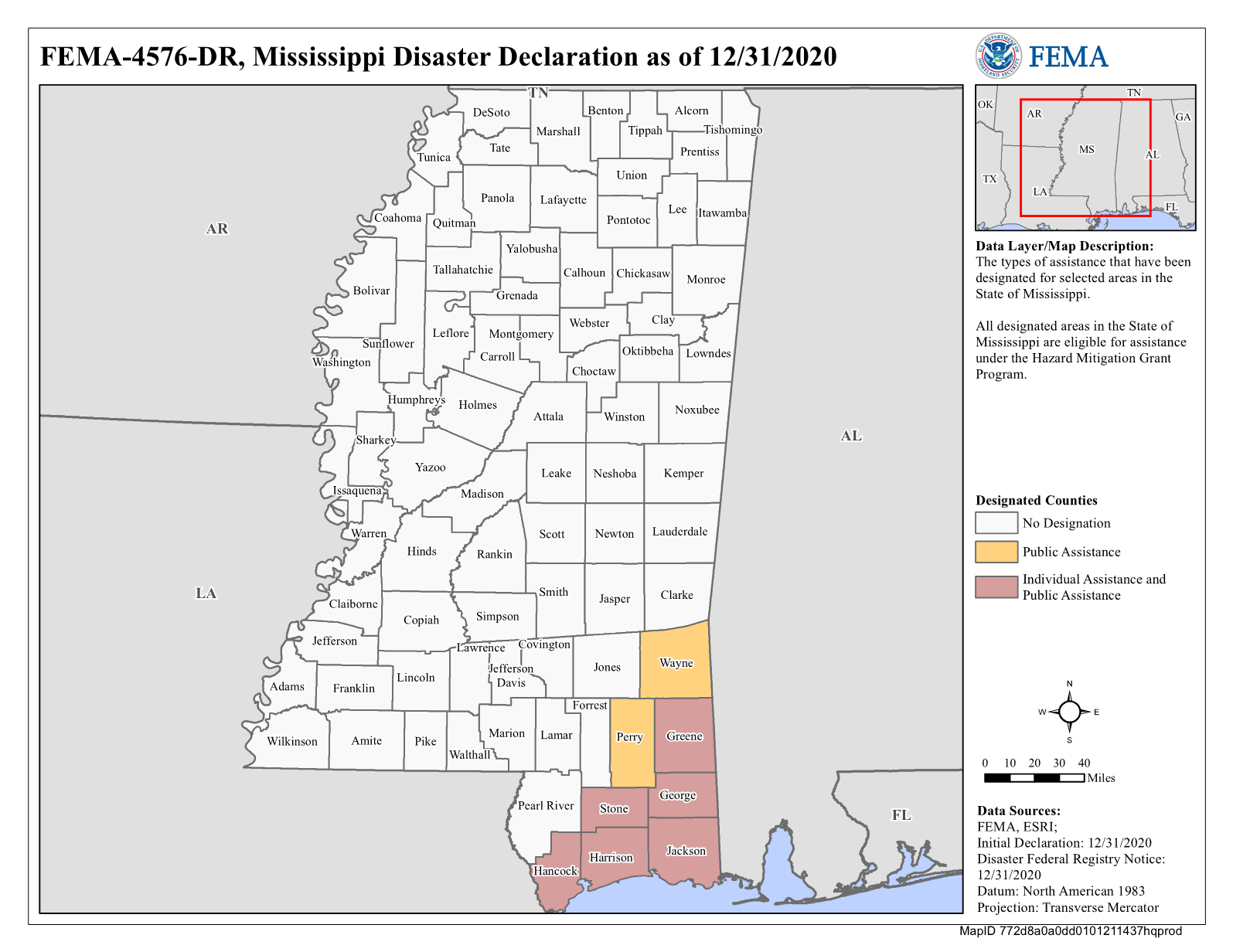
For more information on your area and if you are eligible for FEMA assistance, head here.


