What Are Derechos?
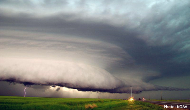
In the weather world, derechos are fast-moving bands of thunderstorms with destructive winds. The winds can be as strong as those found in hurricanes and tornadoes! To be classified as a derecho, the winds have to exceed 57 miles per hour, a damage path must be at least 240 miles long, “severe wind reports must progress chronologically, and there must be 3 reports, separated by 40 miles or more, of F1 damage and/or gusts greater than 74 miles per hour” (A Study of Derechos).
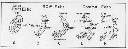
Courtesy of The Weather Prediction – Echo Patterns
Derechos are caused by something called a downburst, which is basically cool, dense air sinking quickly to the surface.
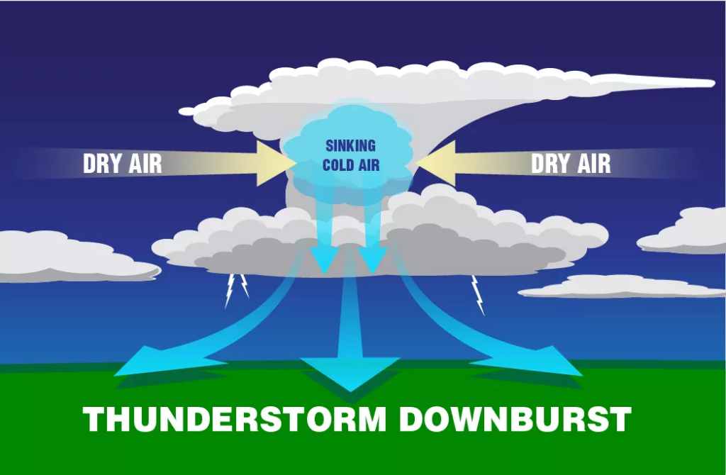
Courtesy of NOAA NESDIS – Downburst Diagram
As the storm grows, it will form a bow echo, which is a curved band of compact thunderstorms moving in one direction.
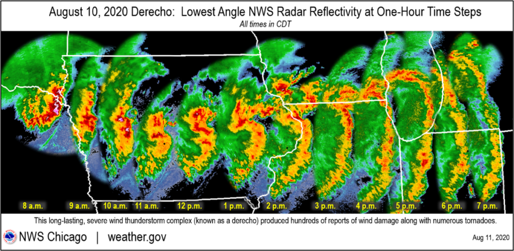
Courtesy of NWS – Bow Echo Evolution
Satellites such as Geostationary Operational Environmental-R (GOES-R) and Joint Polar Satellite System (JPSS) can view derechos from space to predict when they can form.
The Ontario-Adirondacks Derecho
The Ontario-Adirondacks Derecho on July 14th-15th, 1995, was an 800-mile-long path across eastern North America. This severe thunderstorm event spanned over 12 hours, sustained winds above 80 mph, and cost almost 500 million dollars in damage! Seven people were killed, and several dozen were injured.
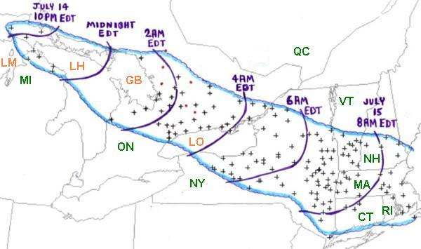
Courtesy of NOAA
The “People Chaser” Derecho
The “People Chaser” Derecho on May 27th-28th, 2001, moved through Kansas, Oklahoma, and Texas. Maximum wind gust in Kansas reached 100 mph, 94 mph in Oklahoma, and 78 mph in Texas. In Oklahoma, the damage was estimated at over 10 million dollars. One person was killed, and at least five were injured.
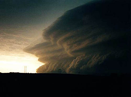
Courtesy of Douglas Berry – ‘People Chaser’ derecho storm system near Fort Supply, OK.
How Are Derechos Changing?
The Southern Plains (Kansas, Oklahoma, and Texas) were known to be the most active region when it came to derecho activity. While the Southern Plains remains the “hub” for derecho formation, there seems to be a shift northward, especially for more high-end events and during the warm season. The Midwest to Ohio Valley (upper Mississippi River valley through the Ohio Valley into Pennsylvania) is emerging as another primary region for derecho formation. The Northern Plains (the Dakotas, Minnesota, and parts of Nebraska) have also increased in derecho activity in recent years.
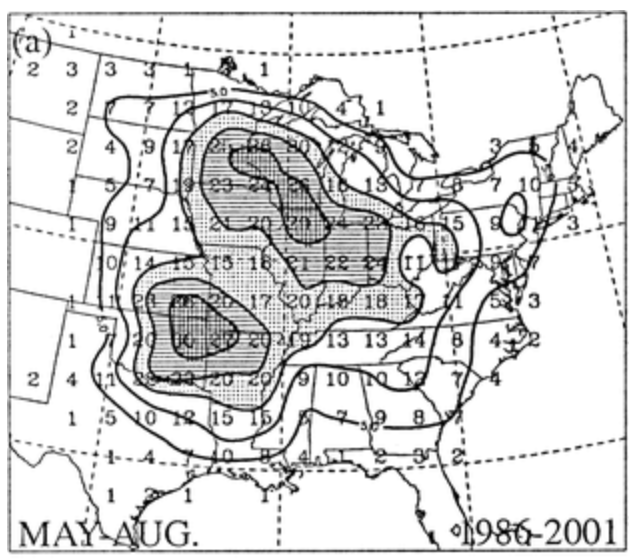
Courtesy of Interpreting the Climatology of Derechos – The distribution of warm-season (May – August) derechos for all 168 events
The reason for the shift is the synoptic-scale patterns, such as strong 500 hPa height gradients and warm-core anticyclones. What do these mean exactly? Well, this has to do with wind shear and a high-pressure system. Wind shear allows for a fast, long-lasting storm, and the high-pressure system traps the warm, moist air. Combining these two makes for a strong mesoscale convective system (MCS).
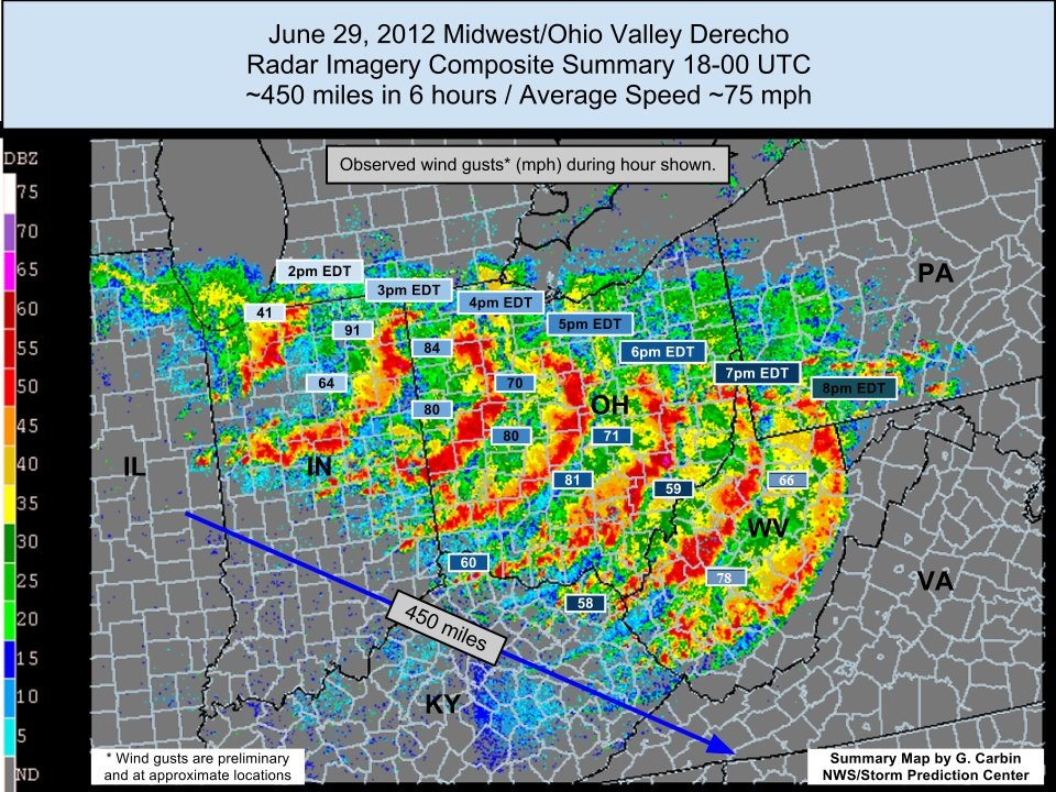
Courtesy of NWS – Derecho Event of June 29th, 2012
The frequency of derechos has increased exceptionally, especially during the warm season. According to the E-Journal of Severe Storms Meteorology, Climatology of 1995–2024 United States Warm Season Derecho Events and Analysis of Potential Climate Forcing Associations, there were, on average, 3 events per year from 1995 to 2004 compared to 7 events per year from 2015 to 2024. Over double the amount! Not to mention triple the amount of high-end events with wind gusts exceeding 38 m/s.
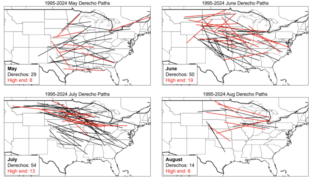
Courtesy of A Climatology of 1995–2024 United States Warm-Season Derecho
Events and Analysis of Potential Climate Forcing Associations – 1995–2024 warm-season derecho approximate path centerlines by warm-season month
The trend is most prominent in the Northern Plains, where there are more frequent detections because of improved wind-reporting networks and mesonet expansions.
Courtesy of NOAA
According to the Journal of Climate, Future Derecho Potential in the United States, as the climate continues to warm, derechos will intensify and expand, especially in the central and eastern United States. Also, according to the Bulletin of the American Meteorological Society, Investigating a Derecho in a Future Warmer Climate, Severe, damaging winds are expected to increase by 50% to 100% in the area being impacted. The reason for this intensification is severe thermodynamic changes such as increased convective available potential energy (CAPE) and higher low-level moisture.
What Does the Future Hold?
In the future, we could see more warm-season derecho events that cover a larger area, especially across the central and eastern states. While the peak winds may not be stronger, the damaging wind paths could double in size. Climate change could be a reason for long-lasting derechos, but it is unclear if the frequency is due to the climate warming.
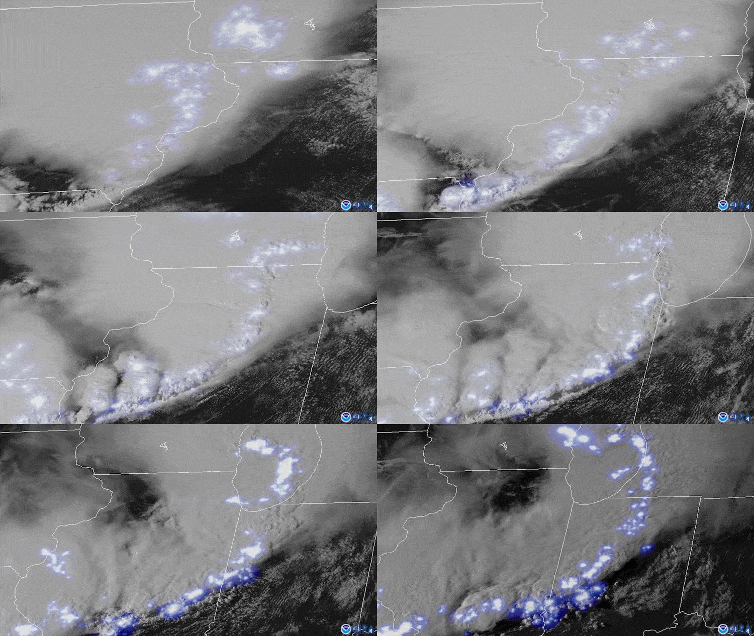
Courtesy of NOAA – Derecho moving across the Midwest
References
https://www.nesdis.noaa.gov/about/k-12-education/severe-weather/what-derecho
https://doi.org/10.1175/1520-0434(2004)019<0595:ITCOD>2.0.CO;2
https://doi.org/10.1175/BAMS-D-24-0140.1
https://doi.org/10.3354/cr024129
https://doi.org/10.55599/ejssm.v20i2.98
https://doi.org/10.1175/BAMS-D-22-0173.1
https://doi.org/10.1175/JCLI-D-23-0633.1
https://www.spc.noaa.gov/misc/AbtDerechos/casepages/jul1995derechopage.htm#4th1995
https://www.spc.noaa.gov/misc/AbtDerechos/casepages/may27-282001page.htm
https://theweatherprediction.com/weatherpapers/031/index.html


