Looking toward Wednesday, the chance for severe weather will emerge across the Gulf Coast as a reasonably potent upper-level system swing through the region. This system is a chunk of a stronger system that is set to plow into the Pacific Northwest earlier in the week.
As this chunk slides southwest and toward Texas, it will start to pull Gulf moisture across the region and eventually set the stage for showers and storms to develop. And because we are easing into the secondary severe weather season for the region, there will also be the potential for severe weather to develop.
The Storm Prediction Center issued a Slight Risk for severe weather last week and hasn’t changed the forecast much through the weekend. Most notably, they haven’t increased the risk, at this point.

The Data
Right now, the main disagreement between all of the model guidance is the timeline for the event. And that difference is messing with the ability to put together an accurate, and precise, forecast for the eventual impacts.
Because the slower the system goes, the longer the atmosphere can ‘prime’ itself for stronger storms. If things move through quicker, then there may not be as much ‘stuff’ for the atmosphere to use to develop stronger storms.
But at the same time, if it takes too long, then it may be an overnight event which, depending on where the lower-level area of low pressure develops, may limit the potency of the stronger storms because then we would have to wait on the overnight low-level jet to get involved.
Here is a look at a handful of different models estimated radar for Wednesday afternoon around 4pm:
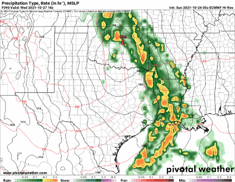
Notice that model guidance shows anything between east Texas and Western Mississippi. And that has a very big impact on the eventual impacts for the region. And specifically for you, the reader!
The Karrie Meter
I was really surprised by how underwhelmed the Karrie Meter was by this setup.

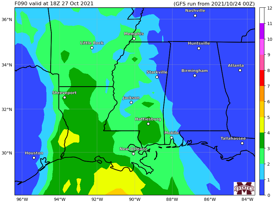

It shows just 3s and 4s. That is a bit lower than the SPC is showing.
I know its been a while since I’ve posted a Karrie Meter Map, so as a reminder anything above a 3 suggests the chance for a few severe storms. Once you get above a 5, you are likely to see at least one severe storm. Above a 7? I’ve found, that at least one significant tornado is likely.
So 3s and 4s, to me, says there is a chance for a few severe storms.
The Forecast
Wednesday Morning:
Increasing clouds with a few instability showers (nothing severe, in fact rarely any thunder or lightning) across the region. Storms may being for eastern and central Louisiana. Severe storms are possible, but not likely during this time period.
Wednesday Afternoon:
Isolated showers and storms possible, some severe, across eastern Louisiana and southern Mississippi. These storms would be well ahead of the front and may have the ability to produce heavy rain, frequent lightning, gusty wind, small hail and the potential to produce weak and brief tornadoes.
Wednesday Evening:
Scattered storms possible, some severe storms possible for southern Mississippi and western Alabama. These storms are likely going to be along the front and in a long line of storms. Heavy rain, lightning, gusty wind, small hail and a few tornadoes will be possible. Any tornadoes would most likely be EF0 and EF1 in strength.
Wednesday Overnight into Thursday:
Scattered storms possible, some severe storms possible for southern Mississippi and Alabama. These storms are likely going to be along the front and in a long line of storms. Heavy rain, lightning, gusty wind, small hail and a few tornadoes will be possible. Any tornadoes would most likely be EF0 and EF1 in strength.
The Bottom Line
The forecast is likely going to change a bit in the coming days as the model guidance comes into better agreement on timing. And once we get a better handle on timing we will get a better idea on the impacts. Particularly for specifics spots (something we can’t do yet.
For the moment, this is a good time to double-check your Severe Weather Plan, make sure your NOAA Weather Radio has fresh batteries and is programmed correctly. And download a good weather app for your phone that will ping you if a warning is issued for your area (always best to have multiple ways to be alerted).
I’ll try to post an update tomorrow and Tuesday as we get closer. And I will try to be available for live coverage if anything truly life-threatening develops.


Thank you for a detailed description of the weather. Your information is easy to read and follow.