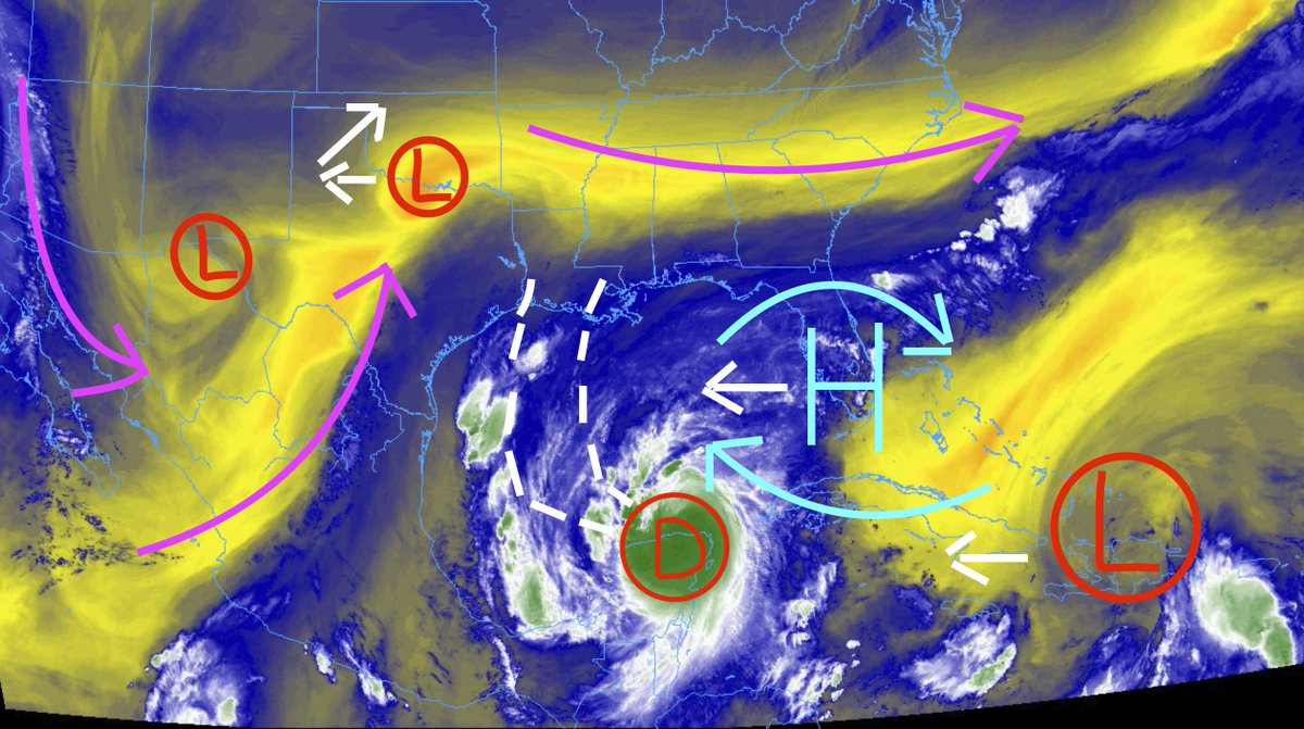
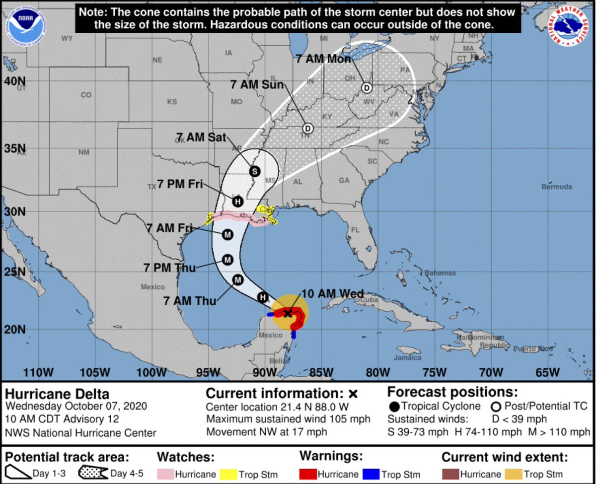
Hurricane Delta is beginning to emerge back over water and into the Gulf of Mexico today. The once-Category 4 storm is now back down to a Category 2 Hurricane. Given all of the moving pieces, it looks like the “strike zone” for a Gulf Coast landfall has shifted a bit to the west overnight.
For folks along the Gulf Coast and in the path of this storm, today is the day to be making your final preps. Landfall is forecast to occur during the day on Friday. Today should be the last day for preparing, giving you tomorrow to ‘dot your Ts and cross our Is’ as my grade school teacher used to joke.
From the NHC
>strong>CURRENT OBSERVATIONS
LOCATION…21.4N 88.0W
ABOUT 65 MI…105 KM WSW OF CABO CATOCHE MEXICO
ABOUT 110 MI…175 KM E OF PROGRESO MEXICO
MAXIMUM SUSTAINED WINDS…105 MPH…165 KM/H
PRESENT MOVEMENT…NW OR 305 DEGREES AT 17 MPH…28 KM/H
MINIMUM CENTRAL PRESSURE…975 MB…28.80 INCHES
FORECAST POSITIONS AND MAX WINDS
INIT 07/1500Z 21.4N 88.0W 90 KT 105 MPH…INLAND
12H 08/0000Z 22.8N 90.2W 95 KT 110 MPH…OVER WATER
24H 08/1200Z 24.3N 92.4W 100 KT 115 MPH
36H 09/0000Z 26.0N 93.3W 105 KT 120 MPH
48H 09/1200Z 28.1N 93.3W 105 KT 120 MPH
60H 10/0000Z 30.8N 92.4W 70 KT 80 MPH…INLAND
72H 10/1200Z 33.2N 90.9W 40 KT 45 MPH…INLAND
96H 11/1200Z 36.5N 86.2W 25 KT 30 MPH…POST-TROP/REMNT LOW
120H 12/1200Z 39.5N 81.0W 20 KT 25 MPH…POST-TROP/REMNT LOW
KEY MESSAGES
1. Life-threatening storm surge and dangerous winds will continue within portions of the northern Yucatan Peninsula of Mexico into early afternoon. Heavy rainfall, which could lead to significant flash flooding, will affect the northern Yucatan Peninsula through early Thursday.
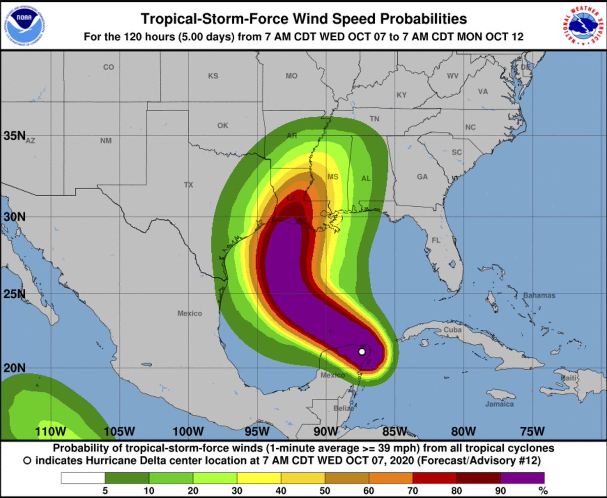
2. Delta is expected to grow in size as it approaches the northern Gulf Coast, where there is an increasing likelihood of life-threatening storm surge and dangerous hurricane-force winds beginning Friday, particularly for portions of the Louisiana coast. Storm Surge and Hurricane Watches are in effect, and residents in these areas should follow advice given by local officials.
3. Flash, urban, small stream, and minor river flooding is likely Friday through Saturday from portions of the central Gulf Coast northward into portions of the Lower to Middle Mississippi Valley. As Delta moves farther inland, additional heavy rainfall is expected in the Ohio Valley and Mid Atlantic this weekend.
DISCUSSION AND OUTLOOK
At 1000 AM CDT (1500 UTC), the center of Hurricane Delta was located near latitude 21.4 North, longitude 88.0 West. Delta is moving toward the northwest near 17 mph (28 km/h). A northwestward motion with a reduction in forward speed is expected over the next 24 hours. A north-northwestward motion is expected by late Thursday, and a faster northward to north-northeastward motion is forecast on Friday and Friday night. On the forecast track, the center of Delta will move over the southern Gulf of Mexico this afternoon, be over the southern or central Gulf of Mexico through Thursday, and approach the northern Gulf coast within the hurricane watch area on Friday.
Maximum sustained winds are near 105 mph (165 km/h) with higher gusts. Re-strengthening is forecast when the hurricane moves over the southern and central Gulf of Mexico through Thursday, and Delta is expected to become a major hurricane again. Some weakening is is forecast as Delta approaches the northern Gulf coast on Friday.
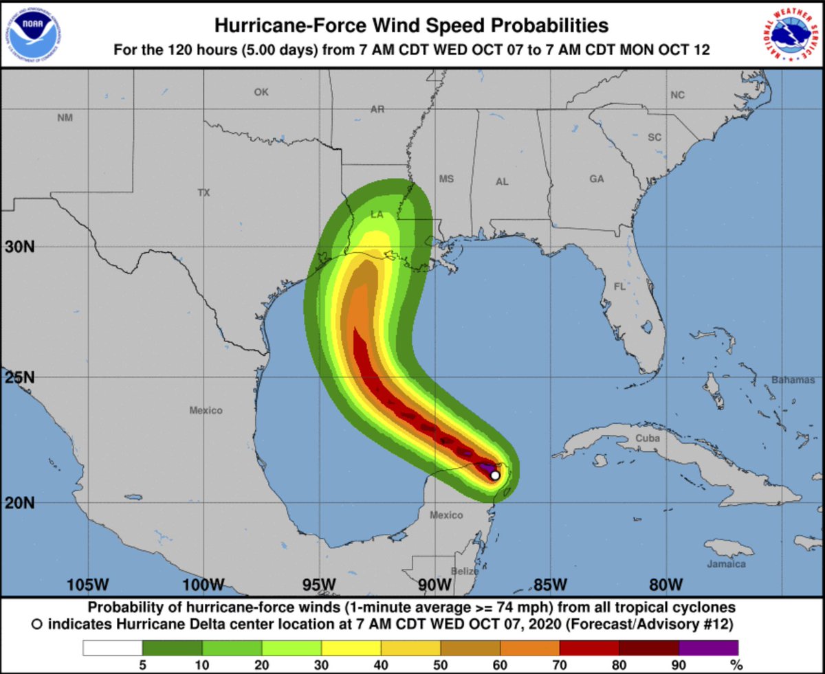
Hurricane-force winds extend outward up to 30 miles (45 km) from the center and tropical-storm-force winds extend outward up to 125 miles (205 km).
The estimated minimum central pressure is 975 mb (28.80 inches).
HAZARDS AFFECTING LAND
STORM SURGE: A life-threatening storm surge will raise water levels in areas of onshore winds by as much as 6 to 9 ft above normal tide levels along the northern coast of the Yucatan Peninsula from Cabo Catoche to Progreso, and 5 to 7 ft above normal tide levels along the eastern coast of the Yucatan Peninsula from Tulum to Cabo Catoche. Near the coast, the surge will be accompanied by large and destructive waves.
The combination of a dangerous storm surge and the tide will cause normally dry areas near the coast to be flooded by rising waters moving inland from the shoreline. The water could reach the following heights above ground somewhere in the indicated areas if the peak surge occurs at the time of high tide…
Pecan Island, LA to Port Fourchon, LA including Vermilion Bay…7-11 ft
Cameron, LA to Pecan Island, LA…4-7 ft
Port Fourchon, LA to Ocean Springs, MS including Lake Borgne…4-6 ft
Lake Pontchartrain and Lake Maurepas…3-5 ft
Ocean Springs, MS to AL/FL border including Mobile Bay…2-4 ft
High Island, TX to Cameron, LA including Calcasieu Lake…2-4 ft
Sabine Lake…1-3 ft
Port O’Connor, TX to High Island, TX including Galveston Bay…1-3 ft
The deepest water will occur along the immediate coast near and to the east of the landfall location, where the surge will be accompanied by large and dangerous waves. Surge-related flooding depends on the relative timing of the surge and the tidal cycle, and can vary greatly over short distances. For information specific to your area, please see products issued by your local National Weather Service forecast office.
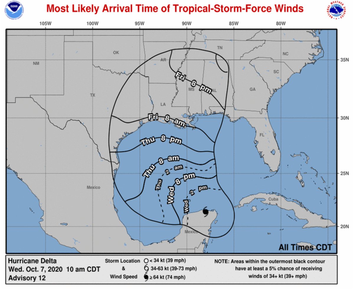
WIND: Hurricane and tropical storm conditions will continue within the warning area in the Yucatan peninsula during the next few hours. Tropical storm conditions are possible within the watch areas along the Gulf coast by late Thursday night or early Friday with hurricane conditions possible within the hurricane watch area by Friday morning.
RAINFALL: Through early Thursday, Delta is expected to produce 4 to 6 inches of rain, with isolated maximum totals of 10 inches, across portions of the northern Yucatan Peninsula. This rainfall may result in areas of significant flash flooding.
Friday through Saturday, Delta is expected to produce 4 to 8 inches of rain, with isolated maximum totals of 12 inches across portions of the central Gulf Coast north into portions of the Lower to Middle Mississippi Valley. These rainfall amounts will lead to flash, urban, small stream, and minor river flooding. As Delta moves farther inland, 1 to 3 inches of rain, with locally higher amounts, is expected in the Ohio Valley and Mid Atlantic this weekend.
SURF: Swells generated by Delta will affect land areas around the northwestern Caribbean Sea today. Swell will begin to affect portions of the northern and western Gulf coast on Thursday. These swells are likely to cause life-threatening surf and rip current conditions. Please consult products from your local weather office.
TECHNICAL DISCUSSION
Satellite and surface observations show that Delta made landfall along the northeastern coast of the Yucatan peninsula around 1030 UTC near Puerto Morelos. A WeatherFlow observing site at Puerto Morelos reported near calm winds and a minimum pressure of around 972 mb when the center passed that location. Another WeatherFlow site near Cancun reported peak sustained winds of 73 kt with a gust to 92 kt. Hurricane-force winds gusts were also reported at an observing site on Cozumel. Since landfall, Delta has moved across the northeastern portion of the Yucatan peninsula and is now about the emerge off the northern coast of the peninsula into the southern Gulf of Mexico. Assuming some weakening has occurred, the initial intensity has been set at 90 kt, but this could be a little generous. An Air Force Reserve Hurricane Hunter aircraft is scheduled to investigate Delta early this afternoon. A NOAA P-3 aircraft has been performing a Tail Doppler Radar mission this morning.
Once Delta moves over the southern Gulf of Mexico, warm waters and expected low vertical wind shear conditions are expected to allow for re-strengthening during the next 24 to 36 hours. After 48 hours, increasing southwesterly shear and cooler waters over the northern Gulf are likely to induce some weakening. The intensity guidance has trended downward this cycle, and the NHC forecast has been adjusted accordingly. Delta, however is still expected to regain major hurricane status and the wind field is likely to grow in size during its approach to the northern Gulf coast, which will increase the storm surge and wind threats. Regardless of Delta’s landfall intensity, life-threatening storm surge and strong winds are likely over a large portion of the northwestern and northern Gulf coast, which has necessitated the issuance of Storm Surge, Hurricane, and Tropical Storm watches for portions of that area.
Delta is moving northwestward or 305/15 kt. The hurricane should continue moving northwestward around the southwestern portion of a subtropical ridge that extends over Florida and the northeastern Gulf of Mexico through early Thursday. After that time, a developing mid-level trough over the south-central United States should cause Delta to slow down and turn north-northwestward on Thursday. Delta is forecast to begin accelerating northward or north-northeastward toward the northern Gulf coast ahead of the trough Thursday night and Friday. There has been little change to the early portion of the track forecast, but there has been a little westward shift in the guidance envelope after 24 hours, and the NHC forecast has been moved in that direction. The new forecast track lies near or just left of the TVCA multi-model consensus and a little right of the HFIP corrected consensus aid, again close to the GFS, GFS ensemble mean, and UKMet models.
Model data
The model data is a lot better today than yesterday. The Hurricane Hunters have made multiple passes through the system and yesterday they sent an additional plane out into the Gulf of Mexico to grab atmospheric observations. In fact, one of the Hurricane Hunters was tweeting about it yesterday!
Flight briefing complete.
Based on our flight pattern, we’re going to say “HI” to Hurricane #Delta. #FlyNOAA pic.twitter.com/zQIPot9AeO
— Tropical Nick Underwood (@TheAstroNick) October 7, 2020
On top of that, a few NWS offices along the Gulf Coast have sent up extra weather balloons to sample the atmosphere, too.
So the data today should be much better. And any shifts seen overnight last night and through the day today are going to be in response to that extra data, not because this storm is inherently unpredictable.
Now, with all of that being said, based on the latest guidance, the landfall point has shifted another – roughly – 30 miles to the west. And the arc around the ridge of high pressure in the Gulf is not as pronounced along the northern edge.
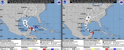
Comparing yesterday afternoon to this morning, you can see the changes in the forecast cone. That is in response to the new data.
The track data has come into pretty decent agreement.
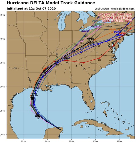
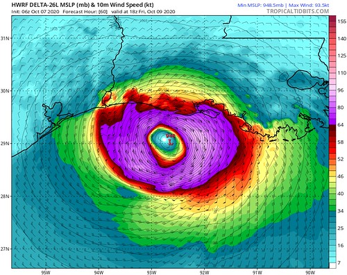
Looking between the HWRF and the HMON model data, the landfall points are pretty close.
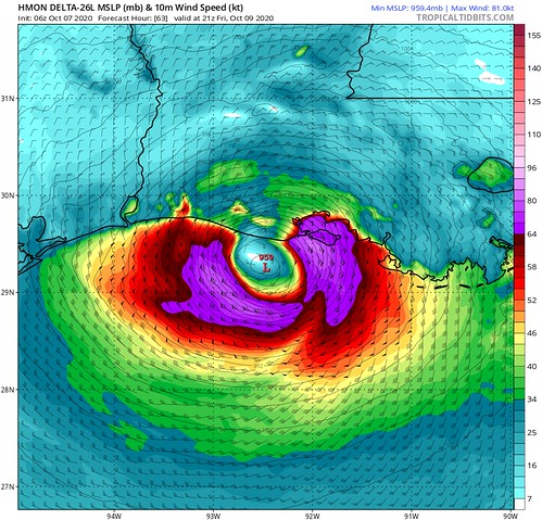
Both models have done reasonably well this season with forecast track guidance. Not perfect, but well. Keep in mind these are just two piece of available data in the mountain of available data. I show these because these models have done the best – recently – in tracking storms. Now, intensity-wise, these have not been as accurate. They have tended to run 10-15mph too high and about 10-15mb too low on pressure.
The intensity guidance – out 48 hours – is also in relative agreement between many of the models.
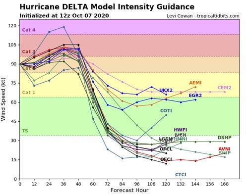
The question becomes, though, just how much of the dry air around the system will be left and how fast will the system be able to get ahold of the warm Gulf of Mexico water.
Local impacts & Bottom Line
For those of you living in southern Mississippi, this will be more of a wind producer than a rainmaker. There will still be rain. And some places may see up to cour to five inches of rain. But the wind is going to be a bigger threat with this storm.
But it won’t be “catastrophic” wind.
Timeline
Friday PM: Wind starts to pick up (gusts up to 30mph) and the first rainbands start to move through the area
Friday overnight: Heavy rain at times, wind gusts up to 60mph, and the potential for brief tropical tornadoes
Saturday AM: Heavy rain at times, wind gusts up to 40mph as the last rainbands move through the area
Saturday PM: Mostly cloudy and breezy (gusts up to 30mph)
Expectations
– There will be some localized flooding, with water coming up in people’s yards and the creeks may rise a bit for a short period of time.
– Power outages will be likely. Prepare to be without power for up to 6 to 12 hours.
– Based on the latest available data, this will not be a widespread catastrophic event for our area. But a some places will still see damage from gusty wind, downed trees and possible tornadoes.


