
We are still a bit too early in the game for specifics like, “XX town will see YY amount of rain” or “ZZ city will experience CC wind speed” but the forecast track and – to some extent – the potential strength of the storm are starting to be knowable given the data that is becoming available.
Right now
The ridge of high pressure slated to build into the region across parts of Florida and the Bahamas is doing so right on schedule.
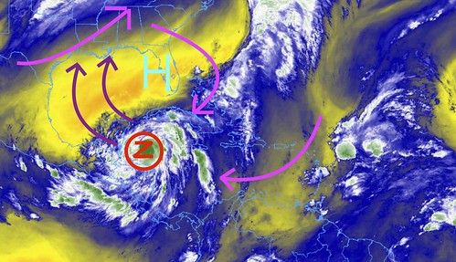
As you can see in the image above, Zeta will be following a track around the ridge as it build in, and ahead of the next area of low pressure – and the adjoining cold front – set to slide through the region. This will allow it to take a rather “Hurricane Delta-like” path through the Gulf.
From the National Hurricane Center

SUMMARY OF 1000 AM CDT
LOCATION…19.1N 85.3W
ABOUT 140 MI…230 KM SE OF COZUMEL MEXICO
MAXIMUM SUSTAINED WINDS…70 MPH…110 KM/H
PRESENT MOVEMENT…NW OR 305 DEGREES AT 10 MPH…17 KM/H
MINIMUM CENTRAL PRESSURE…992 MB…29.29 INCHES
FORECAST POSITIONS AND MAX WINDS
INIT 26/1500Z 19.1N 85.3W 60 KT 70 MPH
12H 27/0000Z 20.1N 86.7W 75 KT 85 MPH
24H 27/1200Z 21.5N 88.8W 65 KT 75 MPH
36H 28/0000Z 23.3N 90.8W 70 KT 80 MPH
48H 28/1200Z 25.7N 91.8W 70 KT 80 MPH
60H 29/0000Z 28.9N 90.7W 65 KT 75 MPH
72H 29/1200Z 33.0N 87.0W 35 KT 40 MPH…INLAND
96H 30/1200Z 40.0N 73.0W 35 KT 40 MPH…POST-TROP/EXTRATROP
120H 31/1200Z…DISSIPATED
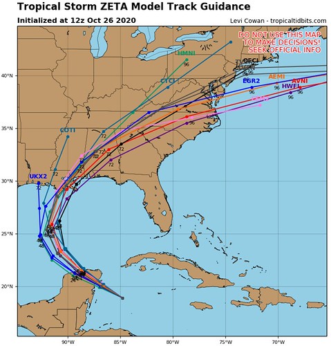
Model data
The morning data has assimilated the Hurricane Hunter data from last night as well as the extra weather balloons being launched by local National Weather Service offices across the Gulf coast and into the Southern Plains. The idea is the NHC and NWS want to have as much accurate data being fed into the models at the start so they can increase the accuracy of the data into the future.
You can see how the lines are now clustered pretty close together showing a Louisiana/Mississippi landfall.
As Zeta rounds the ridge, it will slide through the region from southwest to northeast. The orientation and shape of the ridge, as well as the speed of the area of low pressure swinging through will dictate the direction and speed it will be moving as it makes landfall. Because this system is anticipated to be rather one-sided, this becomes very important when trying to determine who sees what impacts.
Even the Ensemble data show a similar path. And highlight the same orientation issue.
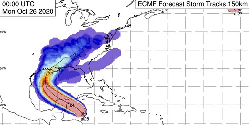
The Euro Ensemble data above shows a stouter and wider ridge that is a bit more flat north-to-south. This would slide Zeta further west in the Gulf and then have it take more of a WSW-to-ENE track across the Gulf Coast states.
While the GFS Ensemble data shows a more circular path.
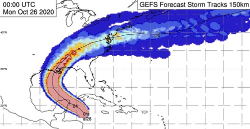
This would indicate a weaker ridge that develops further east, as well as a quicker moving and more northerly area of low pressure moving into the region from the west.
The intensity of the storm, between the model guidance, seems to be becoming more clear as well. Not a lock, but more clear.
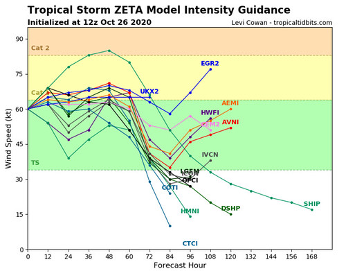
Guidance shows a strong Tropical Storm or Category 1 Hurricane at landfall. This is now the 12th model run in a row showing a similar outcome. That doesn’t – necessarily – mean it can be stronger or weaker, but there is an increased confidence in the intensity ending up between those ‘fence posts’.
The SHIPS Rapid Intensification data has come down a bit today.
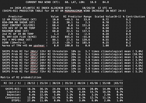
This is a bit more realistic given the current setup. Recall last night, the discussion was about the likelihood of R.I. occurring and I said “color me skeptical” and I’m glad I didn’t bite, because the SHIPS was holding out on R.I. despite given the overwhelming amount of data showing the unlikelihood of it.
Regional Impacts
Given the latest data, I think there is an increased confidence in eventual impacts for some areas. So I will try to break it down again by region, as this is as specific as we can get at this point. Take a look at the map below as a reference for the forecasts.
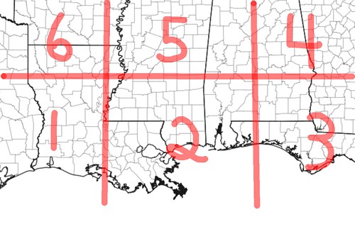
AREA 1
RAIN: Up to 1″
FLOODING: Unlikely
WIND: 10-20mph West, 20-40mph East
SURGE: Unlikely
TORNADOES: Unlikely
POWER OUTAGES: Few, mainly east
START TIME: Wednesday Late AM
END TIME: Wednesday Late PM
LEVEL OF ‘LIFE IMPACT’: West – Very Low ; East – Moderate
AREA 2
RAIN: 2″ to 6″ with up to 8″ possible locally
FLOODING: Brief localized flash flooding possible
WIND: 25-50mph, Gusts to 75mph along coast
SURGE: 1′ to 4′ along coastline
TORNADOES: Possible
POWER OUTAGES: Widespread
START TIME: Wednesday Late AM
END TIME: Thursday AM
LEVEL OF ‘LIFE IMPACT’: High
AREA 3
RAIN: 2″ to 4″
FLOODING: Brief localized flash flooding possible
WIND: 20-40mph, Gusts to 55mph along coast
SURGE: 1′ to 4′ along coastline
TORNADOES: Possible
POWER OUTAGES: Many
START TIME: Wednesday PM
END TIME: Thursday AM
LEVEL OF ‘LIFE IMPACT’: Moderate
AREA 4
RAIN: 2″ to 4″
FLOODING: Brief localized flash flooding possible
WIND: 20-40mph, Gusts to 50mph
SURGE: N/A
TORNADOES: Possible
POWER OUTAGES: Some
START TIME: Wednesday Late PM
END TIME: Thursday PM
LEVEL OF ‘LIFE IMPACT’: Moderate
AREA 5
RAIN: 1″ to 4″
FLOODING: Possible, but not likely
WIND: 15-35mph, Gusts to 45mph
SURGE: N/A
TORNADOES: Possible east, unlikely west
POWER OUTAGES: Few
START TIME: Wednesday Late PM
END TIME: Thursday PM
LEVEL OF ‘LIFE IMPACT’: West – Low ; East – Moderate
AREA 6
RAIN: Up to 1″
FLOODING: Unlikely
WIND: 10-20mph
SURGE: N/A
TORNADOES: Unlikely
POWER OUTAGES: Sporadic
START TIME: Wednesday Late P<
END TIME: Thursday AM
LEVEL OF ‘LIFE IMPACT’: Very Low
And again, because there is going to be a sharp cut-off between impacts, there may be a spots within the boxes where these early estimates are not met.
Bottom Line
Landfall is expected some time during the day on Wednesday. That means Tropical Storm-force conditions may begin as early as pre-dawn on Wednesday morning for some folks right along the Gulf Coast. Prepare now.
For now, not much has changed for your bottom line. If you live along the Gulf Coast between Lake Charles, LA and Pensacola, FL, you need to double-check your Hurricane Preparedness Kit. Not because this has the potential to be some catastrophic Major Hurricane, but rather, because it may bring a fair amount of rain to places that may not be able to handle that rain, as well as some wind gusts that have the potential to knock down trees and knock out power.
If you live within – or near – the Forecast Cone, make sure you have supplies, food, and water to last a few days in case power is knocked out at your house.


