I think I’m going to coin this the “L.I.I.” or “L2I” or “L-double-I” in the future. Landfall, Intensity and Impacts for/from Tropical Storm Zeta. This will be a breakdown of potentials and estimates for the system through the rest of this week based on the latest model guidance and trends.
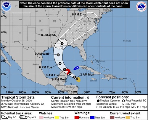
The NHC Forecast
First I want to offer the official NHC forecast. This is what everyone should use to plan with respect to Zeta.
Landfall
Model guidance suggests that the most likely point for landfall is going to be along the Louisiana coastline.
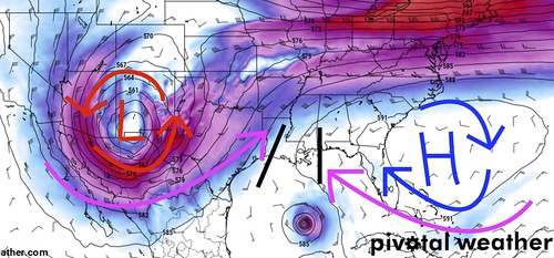
The above image is from Tuesday evening. It shows that the battle between the ridge to the east and the incoming area of low pressure to the west leave a “Gateway” north along the Louisiana coastline. And, in part, across the Mississippi coastline, too.
Looking at model data for 18 hours later, shows that “Gateway” still exists in roughly the same area. Even as the ridge moves east and the area low pressure also moves east.
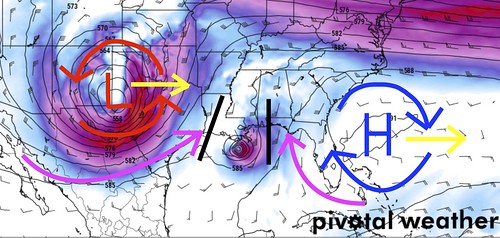
This second image, the right “fence” of the “Gateway” is a bit further east, but in general, the track holds. Now, granted, this is just one model (the GFS computer weather model) and just one run (the 00z data) of that one model. But that “gateway” idea holds true across other guidance, too. Tomer Burg tweeted out a terrific map of a “Super Ensemble” with a bunch of model data plotted on one map.
And it shows roughly the same track that I’ve highlighted.
Here’s the plot updated with all ensemble members (some were previously missing): pic.twitter.com/RuT5g0ucMb
— Tomer Burg (@burgwx) October 26, 2020
That means data suggest that landfall will occur somewhere between Lake Charles, LA and Pensacola, FL. Somewhere near this middle of that lies Morgan City, LA.
Intensity
Trying to decipher a tropical systems intensity beyond 72 hours is difficult. Very difficult. When model guidance has a very good handle on all of the aspects of a situation, it still misses – sometimes by a lot. And even when you have the best meteorologists work on the forecast, they can also still miss.
But, let’s take a look at the guidance and try to make an estimate.
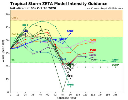
Model guidance shows a strong Tropical Storm or Category 1 Hurricane through the next 72 hours. That lines up with what the NHC is suggesting, too. There is also the chance for Rapid Intensification.
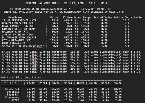
The level of intensity within the potential for R.I. seems to be between 25kts and 55kts of increased intensity during the next 24 to 48 hours. That means on Tuesday night, the SHIPS model that handles the potential for Rapid Intensification is showing a chance that Zeta will have wind speeds between 75kts and 105kts (85mph to 120mph).
While the chance isn’t terrible high, it also isn’t ignorably low.
But is that possible? That is a good question.
Water temperatures in the Gulf would suggest it isn’t very likely at all. The good news is that the Gulf of Mexico is not the Hot Tub it was just a month ago. There are a few spots that have markedly cooler-than-in-August spots.
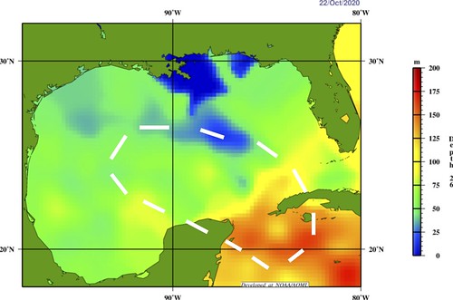
The above graphic is the 26C isotherm. This is a good measure of how voluminously warm the Gulf is, rather than just the surface temperature. The white area is where the GFS and Euro take Tropical Storm Zeta during the next 48 hours where the SHIPS model suggests a potential for Rapid Intensification. You can see it will be over some of the warmest waters of the Gulf.
The Tropical Cyclone Heat Potential map below shows how much “food” is available for a tropical system to “eat” as it moves through an area.
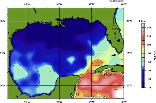
So, not much there.
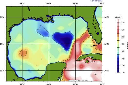
You can see that while there are some areas where the numbers are a bit higher, in general the Gulf isn’t as robustly warm as it was earlier this year. For example, this is what it looks like for Hurricane Sally:
So color me skeptical when it comes to Rapid Intensification, but given what we have seen out of tropical systems this year, I can not completely rule it out.
That said, there is enough heat content in the water, and a favorable enough environment during the next 48 hours for continued strengthening to occur. And I think the model guidance graph from Tropical Tidbits highlights the modeling that seems to have a good handle on what to expect.
By the time Zeta makes it closer to shore, the introduction of shear from the area ow low pressure to the west will start to erode away at the western side of the storm. That will mean a rather one-sided storm at landfall. While it may still be a hurricane, technically speaking, those located on the west side won’t likely see hurricane-force impacts.
It seems reasonable to suggest that Zeta will have wind speeds between 60mph and 80mph at landfall. And this lines up with what the NHC is forecasting, too. That gives extra confidence to the forecast.
Local Impacts
These are always tricky, because these depend on the eventual track of the system and the intensity. So we have made our predictions above for both track and intensity, and now we have to use that to figure out what you can expect. You may say, ‘big deal, why is that hard, most of the work is done already, right?‘
Sort of.
The problem is that Zeta is likely going to be one of these tropical system with a very sharp cut-off for impacts due to the proximity of the cold front and low pressure area sweeping through to pick up Zeta.
In fact, this is likely going to be a situation where the west side of Zeta sees very little rain and some gusty wind – and that’s it. While the east side of the storm, within about 30 miles of the center, sees heavy rain, localized flash flooding, and wind gusts up to 75mph. The rest of the areas impacts to the east will see heavy rain at times, wind gusts up to 50mph, and the chance for a few tornadoes.
So that means over the stretch of about 40 miles west to east, you could go from seeing almost nothing to flash flooding and tornadoes.
That is a very sharp contrast.
One that, at this time, I’m not able to be any more specific than that. All I can say is that there will be a sharp cut-off between the have’s and have not’s when it comes to significant weather from Zeta. So please pay close attention to where this storm is tracking.
But I will try to break it down – in general – by section.
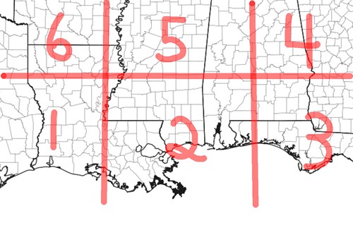
Rain
AREA 1 – Up to 1″
AREA 2 – 1″ to 6″
AREA 3 – 1″ to 3″
AREA 4 – 1″ – 4″
AREA 5 – 1″ to 4″
AREA 6 – Up to 1″
Flooding
AREA 1 – Unlikely
AREA 2 – Possible (Localized brief flash flooding likely)
AREA 3 – Possible (Localized brief flash flooding possible)
AREA 4 – Possible
AREA 5 – Possible
AREA 6 – Unlikely
Wind
AREA 1 – Up to 25mph
AREA 2 – 30mph – 60mph (Gusts to 75mph)
AREA 3 – 20mph – 40mph (Gusts to 55mph)
AREA 4 – 20mph – 50mph (Gusts to 60mph)
AREA 5 – 15mph – 35mph (Gusts to 45mph)
AREA 6 – Up to 25mph
Power Outages
AREA 1 – Unlikely
AREA 2 – Likely (widespread)
AREA 3 – Likely (Sporadic)
AREA 4 – Possible (Sporadic)
AREA 5 – Possible (Sporadic)
AREA 6 – Unlikely
Surge
AREA 1 – Unlikely
AREA 2 – Likely (Est: 1′ – 4′)
AREA 3 – Likely (Est: 1′ – 4′)
AREA 4 – N/A
AREA 5 – N/A
AREA 6 – N/A
When does it start?
AREA 1 – Wednesday AM (Early)
AREA 2 – Wednesday AM (Mid-morning)
AREA 3 – Wednesday PM (Early)
AREA 4 – Wednesday PM (Late)
AREA 5 – Wednesday PM (Late)
AREA 6 – Thursday AM (Early)
When does it end?
AREA 1 – Thursday AM (Early)
AREA 2 – Thursday AM (Early)
AREA 3 – Thursday AM (Early)
AREA 4 – Thursday PM (Mid-afternoon)
AREA 5 – Thursday PM (Mid-afternoon)
AREA 6 – Thursday AM (Early)
And again, because there is going to be a sharp cut-off between impacts, there may be places within the boxes where these early estimates are not met.
When will we know more?
Honestly, late Monday night, once we are within about 48 hours, I should be able to offer a bit more specific detail. However, in this case, because it may end up having a pretty sharp cut-off between impacts, I may not be able to be “super specific” until 24 hours out.
Bottom Line
Landfall is expected some time during the day on Wednesday. That means Tropical STorm-force conditions may begin as early as Tuesday night for some folks right along the Gulf Coast. Prepare now.
For now, not much has changed for your bottom line. If you live along the Gulf Coast between Lake Charles, LA and Pensacola, FL, you need to double-check your Hurricane Preparedness Kit. Not because this has the potential to be some catastrophic Major Hurricane, but rather, because it may bring a fair amount of rain to places that may not be able to handle that rain, as well as some wind gusts that have the potential to knock down trees and knock out power.
If you live within – or near – the Forecast Cone, make sure you have supplies, food, and water to last a few days in case power is knocked out at your house.
As for the more nitty-gritty details, I’ll have a full breakdown about all of the moving parts and model data coming up a bit later tonight.


