The title says it all. This will be a rather odd landfall-tropical-situation along the Gulf Coast. Because while the people who are in the direct path of this system will see the heavy rain, damaging wind, and tornado potential, others only 100 miles away may see almost nothing.
All the while, a cold front is set to move through the region offering a chance for a few thunderstorms, too.
The speed and placement of each puzzle piece meteorologists are tracking will directly – and indirectly – affect the eventual local weather impacts from each.
A lot like some of the other tropical systems in the Gulf this year, this is another unique situation.
Right Now
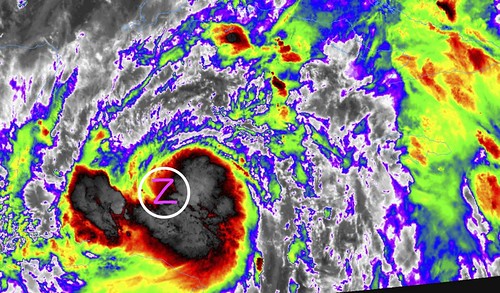
Here is a close-up view of Zeta from the College of DuPage GOES16 page. I’ve tried to highlight the center as best I could. You can see that a lot of the convection is off to the east and south of the center, but it is much better organized tonight that last night and the night before.
A wider view can add context to the upcoming forecast challenges.
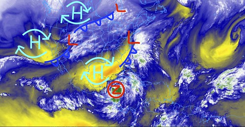
There are a handful of fronts, and a ridge of high pressure to deal with. As well as some dry air in the Gulf and slightly-cooler-than-a-few-weeks ago waters in the Gulf to add to the trickiness of the forecast.
The next front, currently stretching from the Great Lakes back to the Rockies and then dangling back to Pacific, set to move through the Gulf Coast region will be the thing that ‘picks up’ Zeta and ushers it back to the northeast.
The speed of that front will be dictated by the ridge of high pressure in the Gulf and how fast that builds to the east. As well as how strong it becomes as it does build into the area.
Like I said, a lot of moving parts.
From the NHC
SUMMARY OF 1100 PM EDT
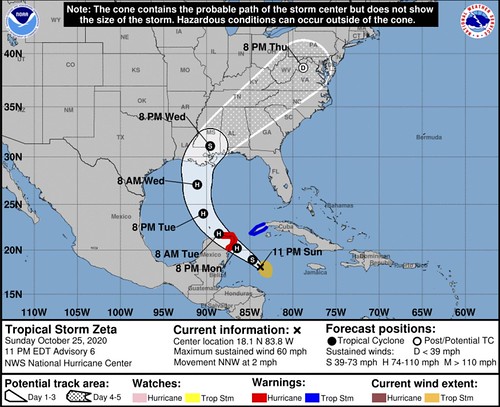
LOCATION…18.1N 83.8W
ABOUT 260 MI…420 KM SE OF COZUMEL MEXICO
ABOUT 270 MI…440 KM SSE OF THE WESTERN TIP OF CUBA
MAXIMUM SUSTAINED WINDS…60 MPH…95 KM/H
PRESENT MOVEMENT…NNW OR 330 DEGREES AT 2 MPH…4 KM/H
MINIMUM CENTRAL PRESSURE…997 MB…29.44 INCHES
FORECAST POSITIONS AND MAX WINDS
INIT 26/0300Z 18.1N 83.8W 50 KT 60 MPH
12H 26/1200Z 18.9N 84.7W 60 KT 70 MPH
24H 27/0000Z 20.2N 86.5W 75 KT 85 MPH
36H 27/1200Z 21.8N 88.6W 65 KT 75 MPH
48H 28/0000Z 24.0N 90.4W 65 KT 75 MPH
60H 28/1200Z 27.1N 91.1W 65 KT 75 MPH
72H 29/0000Z 31.1N 89.6W 50 KT 60 MPH…INLAND
96H 30/0000Z 38.7N 78.8W 30 KT 35 MPH…POST-TROP/EXTRATROP
120H 31/0000Z…DISSIPATED
DISCUSSION AND OUTLOOK
At 1100 PM EDT (0300 UTC), the center of Tropical Storm Zeta was located near latitude 18.1 North, longitude 83.8 West. Zeta is drifting toward the north-northwest near 2 mph (4 km/h) but a faster northwestward motion is expected over the next couple of days, followed by a turn to the north. On the forecast track, the center of Zeta will move near or over the northern Yucatan Peninsula or the Yucatan Channel late Monday, move over the southern Gulf of Mexico on Tuesday, and approach the northern Gulf Coast on Wednesday.
Maximum sustained winds are near 60 mph (95 km/h) with higher gusts. Strengthening is forecast, and Zeta is expected to become a hurricane before it moves near or over the Yucatan Peninsula late Monday.
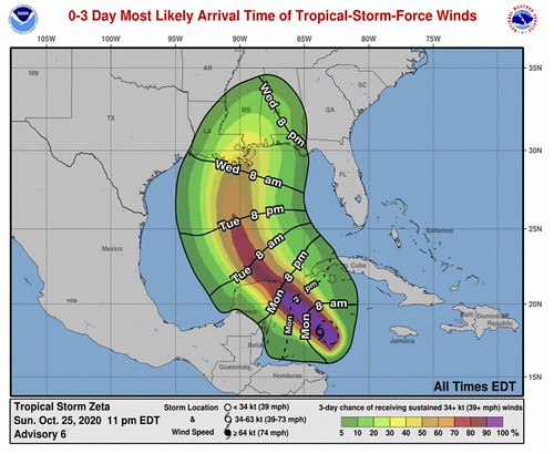
Tropical-storm-force winds extend outward up to 115 miles (185 km) from the center.
The estimated minimum central pressure is 997 mb (29.44 inches).
HAZARDS AFFECTING LAND
RAINFALL: Rainfall totals of 4 to 8 inches with local amounts of 12 inches are possible through Wednesday along and east-northeast of Zetas track from Jamaica, the Cayman Islands, central to western Cuba, and the northeast Yucatan peninsula of Mexico. Additional rainfall amounts of 1 to 2 inches with local amounts of 4 inches possible across Southern Florida and the Keys through Tuesday, with isolated storm total accumulations of 8 inches.
Between Wednesday and Friday, storm total rainfall of 2 to 4 inches, with local 6 inch amounts, is expected across sections of the U.S. Gulf Coast and the southern U.S. near and in advance of Zeta. Heavy rainfall will spread north into the Tennessee Valley, Southern Appalachians, and portions of the Mid-Atlantic States near and in advance of Zeta late in the week. The expected rainfall could lead to flash flooding and minor river flooding.
By Wednesday, heavy rainfall associated with Zeta will begin to affect the central Gulf Coast region, which may lead to flash flooding in urban areas.

WIND: Hurricane conditions are expected within the Hurricane Warning area in the Yucatan Peninsula by late Monday. Tropical storm conditions could occur in the warning area in western Cuba on Monday.
STORM SURGE: A dangerous storm surge will raise water levels by as much as 1-3 feet above normal tide levels along the immediate coast in the Hurricane Warning area near and to the north of where the center makes landfall in the Yucatan Peninsula.
TECHNICAL DISCUSSION
The tropical storm continues to produce deep convection on its south side, with the low-level center estimated to be near the northern edge of the thunderstorms. The last pass from the NOAA Hurricane Hunters a few hours ago indicated that the minimum pressure had fallen to 997 mb, and since the storm appears better organized than before the initial intensity is nudged up to 50 kt. This intensity estimate is slightly above the latest Dvorak numbers. The NOAA Hurricane Hunters are planning to be in Zeta again overnight and that data will be helpful in assessing the storm’s intensity and structure.
Zeta has not moved much during the past several hours, and the initial motion is a very slow north-northwest drift. As ridging begins to build over and near Florida, Zeta is forecast to move faster to the northwest overnight and Monday, and that should take the center of the cyclone near or over the northeastern portion of the Yucatan Peninsula in about 24 hours. The ridge is then expected to shift eastward over the western Atlantic on Tuesday and Wednesday as a large and quite powerful mid- to upper-level low moves eastward across the southwest and south-central United States. This change in the steering pattern should cause Zeta to accelerate northward toward the northern Gulf Coast, and likely make landfall there on Wednesday. The models remain in poor agreement on the details of the evolution of the steering pattern and consequently, there is about a 300 n mi spread in the landfall locations from the various models, which currently spans the region from the far western Florida panhandle to western Louisiana. The NHC track forecast is a little west of the previous one trending toward the middle of the guidance envelope. Based on the poor model agreement, the confidence in the track forecast is lower than normal. It is hoped that data being collected by the NOAA Gulfstream jet flying around Zeta and special NWS weather balloon launches will help the models come into better agreement on the future track of Zeta soon.
Given the low wind shear conditions, moist air mass, and high oceanic heat content over the northwestern Caribbean, steady strengthening seems likely until Zeta reaches the Yucatan Peninsula by late Monday. The cyclone is expected to be a hurricane at landfall in Mexico, and the new forecast shows a slightly higher intensity there based on the new models and favorable conditions. The models differ on how long the core of Zeta will be inland over the Yucatan, but in general, it seems likely that significant weakening won’t occur given the storm’s expected increasing forward speed. The overall environmental conditions are anticipated to remain generally favorable while Zeta moves across the southern Gulf of Mexico, but there should be an increase in shear when it reaches the central Gulf and the cyclone will then be moving over the cooler shelf waters over the northern Gulf. The combination of the stronger shear and cooler waters should cause Zeta to level off in strength and perhaps weaken slightly before the U.S. landfall.The intensity models are in fair agreement, and the NHC forecast lies near the HCCA and IVCN consensus models.
KEY MESSAGES
1. Hurricane conditions and storm surge are expected in portions of the northern Yucatan Peninsula of Mexico Monday night and early Tuesday. Tropical storm conditions could occur over extreme western Cuba on Monday.
2. Through Wednesday, heavy rainfall is expected from Zeta across portions of central and western Cuba, the Cayman Islands, Jamaica, the northeast Yucatan peninsula of Mexico, southern Florida and the Keys. This rainfall could lead to flash flooding in urban areas.
3. Zeta is forecast to be at or near hurricane strength when it approaches the northern Gulf Coast on Wednesday, and there is an increasing risk of storm surge, rainfall, and wind impacts from Louisiana to the Florida Panhandle. Residents in these areas should monitor the progress of Zeta and updates to the forecast.
Bottom Line
Landfall is expected some time during the day on Wednesday. That means Tropical STorm-force conditions may begin as early as Tuesday night for some folks right along the Gulf Coast. Prepare now.
For now, not much has changed for your bottom line. If you live along the Gulf Coast between Lake Charles, LA and Pensacola, FL, you need to double-check your Hurricane Preparedness Kit. Not because this has the potential to be some catastrophic Major Hurricane, but rather, because it may bring a fair amount of rain to places that may not be able to handle that rain, as well as some wind gusts that have the potential to knock down trees and knock out power.
If you live within – or near – the Forecast Cone, make sure you have supplies, food, and water to last a few days in case power is knocked out at your house.
As for the more nitty-gritty details, I’ll have a full breakdown about all of the moving parts and model data coming up a bit later tonight.


