Before I get started about the current tropical situation, take a look at this map from Sam Lillo. This is incredible.
Here’s a map of the amount of time spent in the 5-day NHC forecast cones so far in 2020.
Louisiana has had a cumulative of THREE WEEKS in the cone this year!
And now we have TD 28 tracking toward the same area. pic.twitter.com/dX4J9w6n2z
— Sam Lillo (@splillo) October 25, 2020
Look at how many days some sections of the Gulf Coast have spent “in the cone” from the NHC this season. I can totally understand why everyone says, “Not again!” when they see something brewing in the Tropics. Not only has it “felt” like parts of the Gulf Coast have been “in the cone” a ton this summer, they literally have been.
Crazy.
Okay! On to the update…
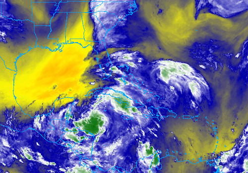
Down in the tropics, now-Tropical Storm Zeta continues to get better organized. The National Hurricane Center says that during the day on Sunday, they expect it to become a Hurricane as it traverses the Caribbean and moves into the Gulf of Mexico.
From the NHC

KEY MESSAGES
1. The depression is forecast to strengthen to a tropical storm by Sunday and tropical storm conditions are expected in extreme western Cuba on Monday. Tropical storm conditions are possible in the northern Yucatan Peninsula of Mexico Monday night and early Tuesday.
2. Through Wednesday, heavy rainfall is expected across portions of central and western Cuba, the Cayman Islands, Jamaica, the northeast Yucatan peninsula of Mexico, southern Florida and the Florida Keys. This rainfall may lead to flash flooding in urban areas.
3. The system is forecast to approach the northern Gulf Coast as a tropical storm Tuesday night and Wednesday, and could bring storm surge, rainfall, and wind impacts to areas from Louisiana to the Florida Panhandle. Residents in these areas should monitor the progress of the depression and updates to the forecast.
FORECAST POSITIONS AND MAX WINDS
INIT 25/0300Z 18.9N 83.1W 30 KT 35 MPH
12H 25/1200Z 19.2N 83.3W 35 KT 40 MPH
24H 26/0000Z 20.0N 83.7W 40 KT 45 MPH
36H 26/1200Z 20.7N 84.9W 50 KT 60 MPH
48H 27/0000Z 21.7N 86.6W 55 KT 65 MPH
60H 27/1200Z 23.2N 88.6W 65 KT 75 MPH
72H 28/0000Z 25.4N 90.3W 65 KT 75 MPH
96H 29/0000Z 31.5N 89.5W 40 KT 45 MPH…INLAND
120H 30/0000Z…ABSORBED
Model data
The Hurricane Hunters spent the day flying in and out of Zeta. The data collected has increased the agreement between the model data for storm track.
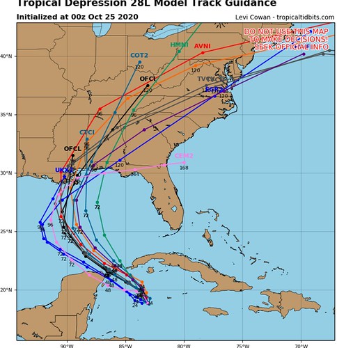
Most of the model guidance now takes the system into the Gulf and then to the north and back to the northeast near , or shortly after, landfall.
The model data for intensification does show a bit of a “higher ceiling” for intensity, but that is mainly for the short-term and not as much for near landfall.
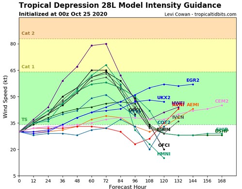
Since landfall is expected to be beyond the 72-hour window, looking at the intensity guidance above, you can see that the storm is expected to weaken leading up to landfall. This is due to the cooler water temperatures and increased shear in the region.
The SHIPS model showing the percent-chance for Rapid Intensification shows some intriguing – but not compelling – numbers.
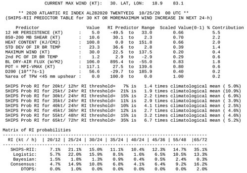
The 35-percent chance to gain 65kts in 72 hours is a bit higher than the NHC official forecast, so this will need to be monitored.
The Bottom Line
This is likely to be more of a rainfall and surge event than a wind event – where ever it goes. As I mentioned earlier today, specifics about “How much rain?” and “How much surge?” and “What will happen at my house?” aren’t knowable yet.
As the track comes into better agreement and the intensity guidance gets better, we will know more. I really think that we will start to be able to give more specifics by early Monday morning.
But, we do know that Rapid Intensification into a Major Hurricane is less likely with this storm than previous storms that entered the Gulf earlier this year. Is it impossible to see Rapid Intensification into a Major Hurricane? No, it could happen. But the chances that it happens – at this point – are very low.
Double check your Hurricane Preparedness Kit, not because this is expected to come to your house and expected to be a Major Hurricane… But, with enough rain and some wind (even gusts around 40mph) can cause power outages. So just double check things and make sure you are prepared.
Hang in there, though. We will know more in the coming days.


