
The National Hurricane Center is very confident that Invest 95L will organize into a Tropical Depression, or perhaps even a Tropical Storm, by later today.
The model guidance is starting to come into better agreement. The thought is, in general, that Invest 95L will lift north into the Gulf and then slide north toward the northern Gulf Coast as the next cold front arrives. The timing of the next front, strength and organization of Invest 95L, and thus the eventual track and impacts are still ‘to be determined’ but we are starting to get a better idea about how things will shake out.
From the NHC
Satellite, radar and surface data indicate that an area of low pressure located about 125 miles west-southwest of Grand Cayman Island continues to become better organized, and if current trends continue, advisories will be initiated on a tropical depression this afternoon or evening. Environmental conditions are conducive for
further development while the low drifts toward the north and northwest this weekend. The system could move near western Cuba on Monday and move across the southern Gulf of Mexico or the northeastern portion of the Yucatan Peninsula on Tuesday. Interests in western Cuba and the Yucatan Peninsula should monitor the
progress of this low. A NOAA Hurricane Hunter reconnaissance aircraft is en route to investigate the disturbance this afternoon. Regardless of development, locally heavy rainfall will be possible over portions of the Cayman Islands, Jamaica, Cuba, and northeastern Yucatan through early next week.
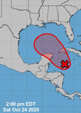
* Formation chance through 48 hours…high…near 100 percent.
* Formation chance through 5 days…high…near 100 percent.
Model data
As I mentioned above, the model data is starting to come into better agreement. As usual, when systems start to develop a localized center of low pressure, it gives these models something to ‘grab on to’ to make a prediction.
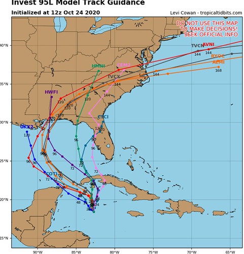
While there is still some spread in the guidance, there is a cluster that has formed along the central Louisiana coast east through the western Florida panhandle.
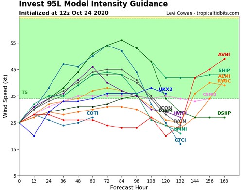
Model intensity guidance is also showing the chance that Invest 95L stays as a Tropical Storm and doesn’t intensify into a hurricane.
Impacts
This is likely to be more of a rainfall and surge event than a wind event. Specifics about “How much rain?” and “How much surge?” and “What will happen at my house?” aren’t knowable yet.
But, we do know that Rapid Intensification into a Major Hurricane is less likely with this storm than previous storms that entered the Gulf this year. Is it impossible to see Rapid Intensification? No, it could happen. But the chances that it happens – at this point – are very low.
Water Temperatures
There is some new research out there that I haven’t read yet indicating that the isotherm in the Gulf may be more important than originally thought. I haven’t read the research paper yet, but the premise is that the weaker tropical systems during the past few years have mixed out the “much cooler” water and left a Gulf with “very warm,” “warm,” and “not as warm” waters. Compared to in decades past when hurricanes and cold fronts would really mix out some of the “very warm” water with “much cooler” water.
The researchers claim this may be why we’ve seen hurricanes continue to strengthen so close to landfall in the Gulf in recent years.
I’m trying to find this paper, but I haven’t had a chance to get my hands on it yet. I am intrigued, though.
Back to the current conditions, though. The good news is that the Gulf of Mexico is not the Hot Tub it was just a month ago. There are a few spots that have markedly cooler-than-in-August spots.
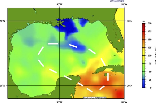
The above graphic is the 26C isotherm. This is a good measure of how voluminously warm the Gulf is, rather than just the surface temperature. The white area is where the GFS and Euro take Invest 95L during the next five to seven days. You can see it will be over the warmer waters of the Gulf.
The Tropical Cyclone Heat Potential map below shows how much “food” is available for a tropcial system to “eat” as it moves through an area.
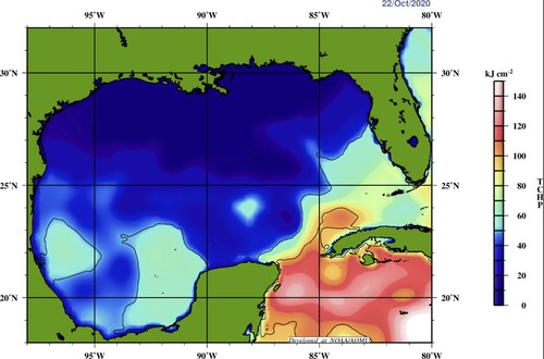
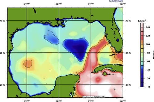
You can see that while there are some areas where the numbers are a bit higher, in general the Gulf isn’t as robustly warm as it was earlier this year. For example, this is what it looks like for Hurricane Sally:
The Bottom Line
Double check your Hurricane Preparedness Kit, not because this is expected to come to your house and expected to be a Major Hurricane… But, with enough rain and some wind (even gusts around 40mph) can cause power outages. So just double check things and make sure you are prepared.
We will know more in the coming days.


