You may have heard me joke the other day that this thing was like that scene from the comedy, Austin Powers. Where, when falling out of a building he lands on a woman (who had already been shot, I believe).
Seriously, though. This is how I feel with this thing.
Just. Go. Away.
But it won’t.
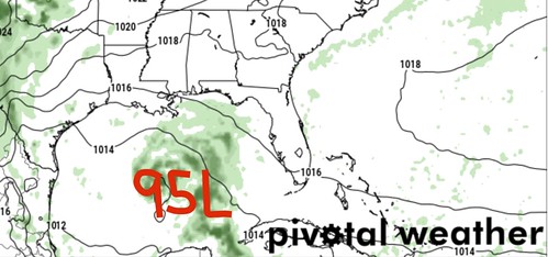
As Hurricane Epsilon cruises north out in the open Atlantic, newly-minted Invest 95L in the Caribbean is set to drift north in the coming days. Model guidance is starting to come into better agreement that there may be two pieces of Invest 95L – one that gets torn off and moves northeast and toward the Bahamas, and another that sneaks behind that and into the Gulf of Mexico.
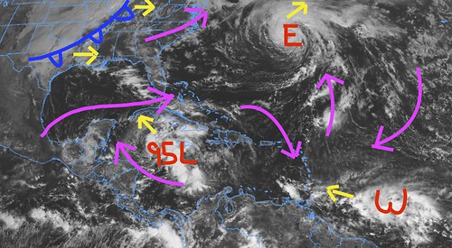
The image above shows where Epsilon, Invest 95L, and another tropical Wave are located (in red) right now, as well as their movement (yellow arrows). I’ve also overlaid the prevailing flow (pink arrows) in the atmosphere, too. And added the cold front.
So there are a lot of moving parts out there, like usual, dictating exactly how things are going to play out in the coming days.
From the NHC
A broad area of low pressure located near Grand Cayman Island is producing a large area of showers and thunderstorms mainly east and south of the center. This system has become much better organized since yesterday, and a tropical depression could form during the next couple of days while the low moves slowly toward the northwest. This system is now anticipated to move near western Cuba this weekend and move slowly across the southeastern Gulf of Mexico by early next week. Regardless of development, locally heavy rainfall will be possible over portions of the Cayman Islands, Cuba, southern Florida and the Keys, and the northwestern Bahamas through the weekend.
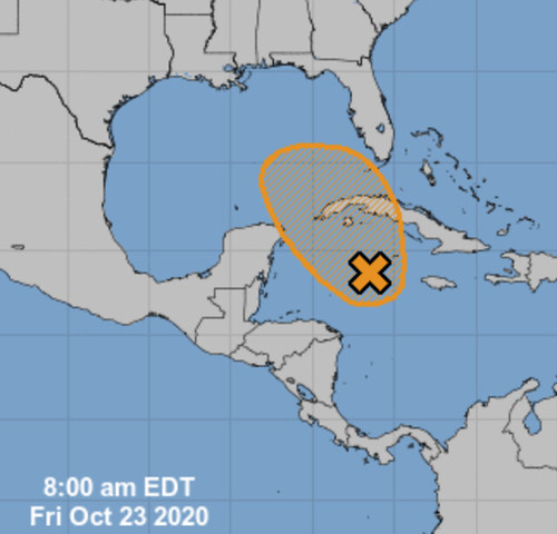
* Formation chance through 48 hours…medium…50 percent.
* Formation chance through 5 days…medium…60 percent.
Model data
Right now, model guidance for what will happen with Invest 95L is more general than specific. Since it is still an “Invest,” and has no defined center, the models have a difficult time figuring out where it is going.
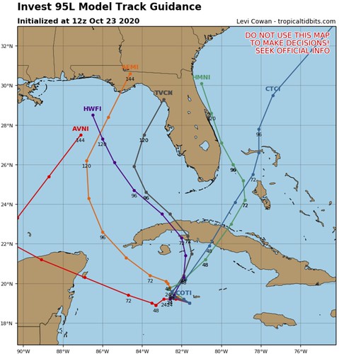
The global computer weather models, both the GFS and Euro, have one piece lifting northeast with the first cold front and another lifting north toward the Gulf after the front passes through.
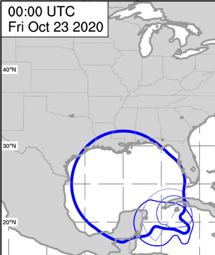
Both models put 95L in the central Gulf by midweek next week. But, as you can see from Alan Brammer’s model data, the “cone” for where Invest 95L may potentially be during the next seven days is…. large.
Water Temperatures
There is some new research out there that I haven’t read yet indicating that the isotherm in the Gulf may be more important than originally thought. I haven’t read the research paper yet, but the premise is that the weaker tropical systems during the past few years have mixed out the “much cooler” water and left a Gulf with “very warm,” “warm,” and “not as warm” waters. Compared to in decades past when hurricanes and cold fronts would really mix out some of the “very warm” water with “much cooler” water.
The researchers claim this may be why we’ve seen hurricanes continue to strengthen so close to landfall in the Gulf in recent years.
I’m trying to find this paper, but I haven’t had a chance to get my hands on it yet. I am intrigued, though.
Back to the current conditions, though. The good news is that the Gulf of Mexico is not the Hot Tub it was just a month ago. There are a few spots that have markedly cooler-than-in-August spots.
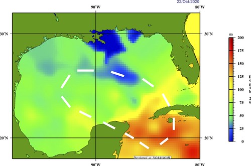
The above graphic is the 26C isotherm. This is a good measure of how voluminously warm the Gulf is, rather than just the surface temperature. The white area is where the GFS and Euro take Invest 95L during the next five to seven days. You can see it will be over the warmer waters of the Gulf.
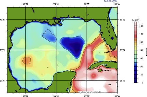
The Tropical Cyclone Heat Potential map below shows how much “food” is available for a tropcial system to “eat” as it moves through an area.
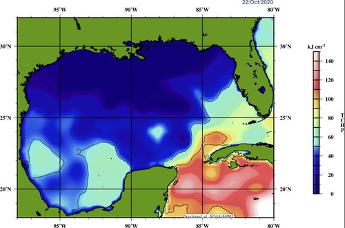
You can see that while there are some areas where the numbers are a bit higher, in general the Gulf isn’t as robustly warm as it was earlier this year. For example, this is what it looks like for Hurricane Sally:
Bottom Line
There is a lot we don’t know about this one right now. But – in general – late October tropical systems are mainly surge producers and rain makers for the Gulf Coast. They aren’t – again, generally – known to be wind machines.
But we will continue to monitor this one and offer updates when possible.


