Eta is a shell of its former self, however it is still dropping copious amounts of precipitation across Central America. Nicaragua and Honduras are still expecting another foot of water – maybe more – in some spots.
And it really is going to slither north. No, but really. Look at the Forecast Cone from the NHC. It moved west into Nicaragua, now it is moving back to the NE toward Cuba, only to turn back NW into the Gulf.
As I mentioned the other day on TV, this may take a rather Elena like path northward, wobbling back and forth.
Right Now

Eta is sitting over land continuing to weaken and drop a ton of rain. IT may lose its tropical characteristics during the next 24 to 48 hours. And the low-level center may shift position drastically as it gets decoupled from the mid-level center.
This disorganization process throws a bit of a wrench into the forecast down the line. As a lot of you guys know from reading this blog over the years, if a tropical system is disorganized the models have a more difficult time “latching on” to the system to make an accurate prediction about where it may go next.
Currently, and up until this point, there has been enough of organization to accurately predict where it has been, but moving forward things may get a bit more questionable.
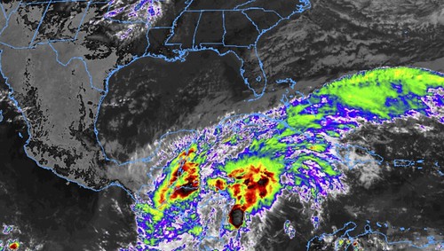
Also of note are the pieces of the puzzle – or the proverbial ‘players on the field’ – with Eta’s trip north. The ridge to the NE right now its helping to steer it to the NW. The cold front across the southern plains of the United States isn’t a big player, but the associated trough in the mid-levels is. That is noted on teh image above by the pinkish arrow across the Gulf. That will help move Eta back to the east as it lifts north.
Then a ridge that may build in behind this trough may help to guide Eta back to the northwest as it enters the Gulf.
At least, as of now, those are the identifiable pieces to watch in the coming days. How they move independently, and relative to each other, is how we will figure out where Eta ends up going.
From the NHC

SUMMARY OF 1200 PM CST
LOCATION…13.9N 85.6W
ABOUT 125 MI…200 KM NNE OF MANAGUA NICARAGUA
MAXIMUM SUSTAINED WINDS…45 MPH…75 KM/H
PRESENT MOVEMENT…W OR 275 DEGREES AT 7 MPH…11 KM/H
MINIMUM CENTRAL PRESSURE…998 MB…29.47 INCHES
The National Hurricane Center pegs Eta to move northwest through the Nicaragua and parts of Honduras before moving back to the northeast and out into the Caribbean. The current forecast shows it will redevelop tropical characteristics quickly and redevelop into a Tropical storm as it moves northwest toward Florida. Then, as a ridge builds hinto the northeast of Eta as it approaches Florida, it will shift back to the northwest into the Gulf.
FORECAST POSITIONS AND MAX WINDS
INIT 04/1500Z 13.9N 85.2W 45 KT 50 MPH…INLAND
12H 05/0000Z 14.1N 86.3W 30 KT 35 MPH…INLAND
24H 05/1200Z 14.9N 87.7W 25 KT 30 MPH…INLAND
36H 06/0000Z 16.0N 88.7W 25 KT 30 MPH…POST-TROP/REMNT LOW
48H 06/1200Z 17.0N 88.2W 30 KT 35 MPH…OVER WATER
60H 07/0000Z 18.0N 86.4W 35 KT 40 MPH
72H 07/1200Z 19.6N 84.4W 40 KT 45 MPH
96H 08/1200Z 23.0N 81.5W 45 KT 50 MPH
120H 09/1200Z 25.0N 82.0W 50 KT 60 MPH
TECHNICAL DISCUSSION
Eta is weakening as it moves across northern Nicaragua, Most of the inner core convection has weakened, and the strongest convection is now in bands well removed from the center. There are no wind observations available near the center of Eta at this time, so the initial intensity is reduced to a uncertain 45 kt.
The initial motion is westward or 275/6. A mid-level ridge to the north of the cyclone should steer it on a generally west-northwestward track during the next 36 h or so. After that time, a mid- to upper-level trough moving over the central and eastern Gulf of Mexico is expected to cause Eta or is remnants to turn northward and then northeastward, Then, by 120 h, the cyclone is likely to move northward on the eastern side of the trough. While the track guidance is in reasonable agreement with this scenario, there is some spread on when and where the various turns will occur, and thus there is a fair amount of uncertainty about what parts of Cuba and Florida the center may pass near or over. The new forecast track is similar to the previous track and lies near the various consensus models.
Eta will continue to weaken while it crosses Nicaragua and Honduras, and it is expected to decay to a remnant low before it reaches the Gulf of Honduras or the northwestern Caribbean Sea. Re-development is expected once the center is over the water. However, interaction with the aforementioned trough could result in a structure that is more subtropical or hybrid, as indicated by the GFS/HWRF, than a classical tropical cyclone, as suggested by the ECMWF. The new intensity forecast will follow the previous forecast and go with a gradual intensification in the expectation that the GFS scenario is more likely to verify, However, the intensity forecast lies a little below the intensity consensus.
Although it is weakening, Eta will continue to produce heavy rainfall and flooding over portions of Central America.
Model Data
A good example of what I was talking about above with models ahving a difficult time finding a center of an organized system and thus struggling to offer an outcome is this…

That si a look at the GFS ensemble plot. Really living up to the name “spaghetti” plot, that really does look like a plate of spaghetti was thrown on to a map.
This isn’t the only model we use for forecasting, thankfully, but it does highlight a potential problem when forecasting the track.
Other model guidance is a bit more consistent.

Once Eta makes it back over water again, and reorganizes a bit, the Hurricane Hunters can fly back through it to continue to gather valuable data. But for now, we have to use the tools and models without that data.
The interesting point to note is the westward shift of the lines since this time yesterday. Suggesting a better chance Eta traverses Cuba and gets into the gulf moving northwest, rather than moving over florida and then shifting northwest.
Water Temperatures
A quick – very quick – note abotu water temperatures in the Caribbeana nd the Gulf where Eta is forecast to travel: Warm. Especially south. Not a hot tub in the Gulf anymore, but still warm enough.

And still – in spots – as warm as when Hurricane Michael moved through parts of the Gulf in 2018.

That’s not to say Eta will develop into a Major Hurricane. But it is offered only to point out that the Gulf isn’t “turned off” for the season.
The Bottom Line
There is still a lot we don’t know with Eta and how it may impact the Gulf Coast. Please check back for future forecasts and updates.


