It is like the start of a bad joke, am I right?
So, T.D. Two, Invest 92L and another Tropical Wave walk into a bar… Bartender says “hey, we don’t like dealing with your kind of pressure.” The system look at eachother, shrug and say, “That’s fine, we prefer milli-bars anyway.”
Get it. Milli bars.Millibars. A measurement of pressure. Used for measuring the atmosphere. Particularly cyclones.

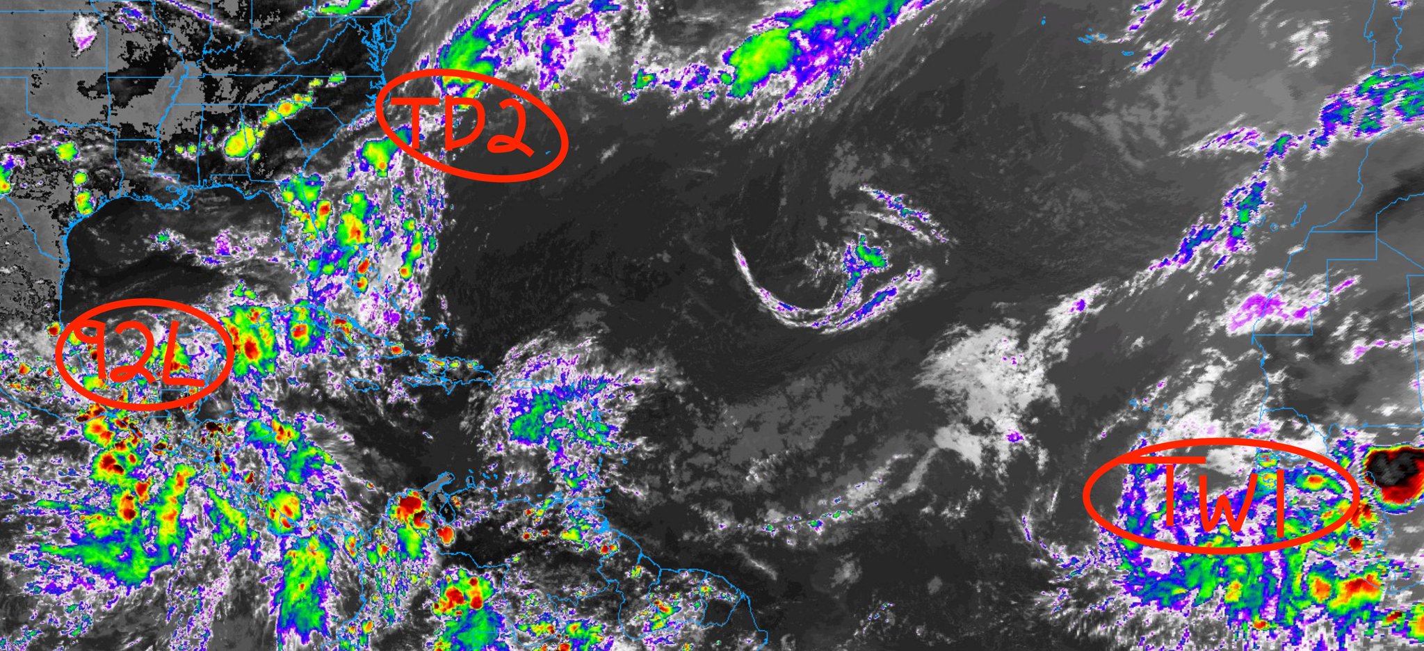
All jokes aside, there are three areas to watch int he Tropics. Two will have zero impact on the Gulf during the next seven days (or forever) and one will definitely have an impact.
Tropical Depression Number Two
The National Hurricane Center began issuing advisories on Tropical Depression Two earlier today.
The system formed off the coast of the Carolinas and is heading out to sea. A lot like Dolly and Kyle last year, this one will only be a problem for shipping channels and the fish.

The NHC pegs this to become a Tropical Storm (Bill) before is turns extra-tropical. Not much to write about here.
Tropical Wave near Africa
Interesting to see a wave get any kind of attention this far out there in June. The area where this wave is moving is somewhere that we would typically be looking in August and September.
But June? Man.
From the NHC:
A strong tropical wave located several hundred miles south- southeast of the Cabo Verde Islands is maintaining a large but disorganized area of shower and thunderstorm activity. Some development of this system is possible during the next few days before a combination of dry air aloft and strong upper-level winds limit any chance of formation while the wave is over the central tropical Atlantic Ocean late this week.
* Formation chance through 48 hours…low…10 percent.
* Formation chance through 5 days…low…20 percent.
This one – while writing this update – was minted as Invest 94L. And I was going to change it throughout, but it would’ve ruined my amazing Dad Joke, so I left it until now.


Interesting to note that the track forecast fo this takes it across where a ridge of high pressure should be building as we head through Days 5-8. That ridge would tend to nudge it a bit farther south. Not terribly important, since I am not overly impressed with the likelihood that this actually turns into anything – but hey, if 2020 taught me anything about tropical systems it was, “weirder things can always happen.”
But, again, this will be of little concern to anyone along the Gulf Coast during the next week. Or perhaps ever.
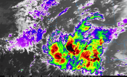
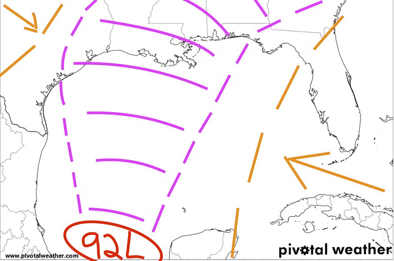
Invest 92L
Still floating around the Gulf, Invest 92L is not really in a hurry. To do… well… anything. The Euro ensembles have a general direction they want to take Invest 92L.
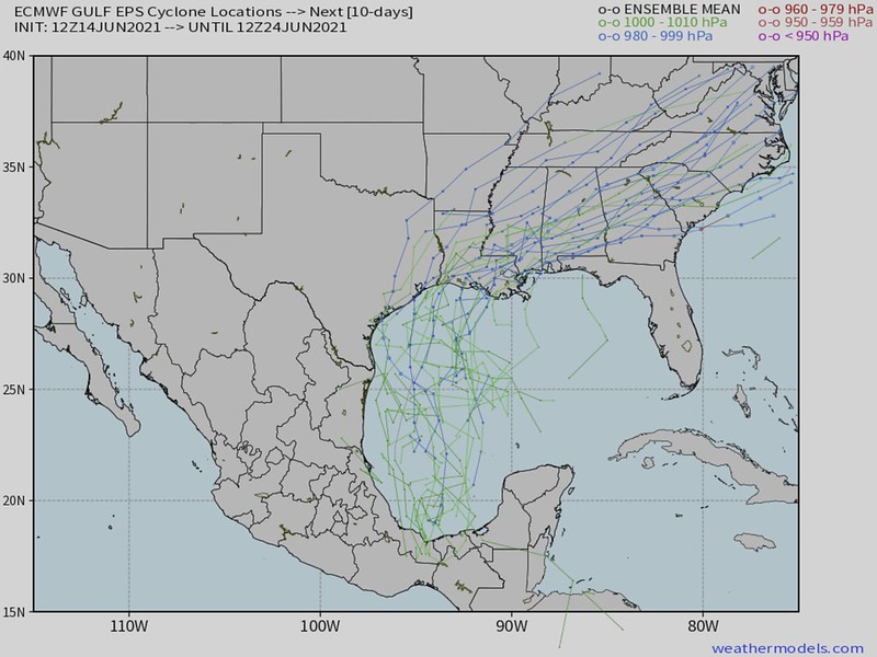
But landfall within most of the model guidance won’t happen before Friday night. And the system may roll around in the Bay of Campeche through Thursday and then zip north toward the Gulf Coast Thursday and Friday.
From the NHC:
Disorganized showers and thunderstorms continue over the Bay of Campeche in association with a broad low pressure area. Gradual development of this disturbance is possible during the next couple of days while it meanders near the coast of Mexico. The system should begin to move northward by midweek, and a tropical depression is likely to form late in the week when the low moves across the central or northwestern Gulf of Mexico. Regardless of development, heavy rainfall is possible over portions of Central America and southern Mexico during the next several days. Heavy rains could also begin to impact portions of the northern Gulf Coast on Friday. Please consult products from your local meteorological service for more information.
Courtesy: nhc.noaa.gov
* Formation chance through 48 hours…low…20 percent.
* Formation chance through 5 days…high…70 percent.
You can see that a little better on the GEFS model data from Tropical Tidbits.

In terms of intensity, not much has changed there in the last 24 hours, still looking llike – most likely a Tropical Storm at landfall.

History
Taking another look back at history, you can see that Major Hurricanes don’t often form from this section of the Gulf of MExico in June.

The history books only note 1934 and 1957 as the only two years that featured a hurricane stronger than a Category 1 to develop from this region.
So the while it is possible, it is not very likely at all.
Historically, storms that form in this region of the Gulf during this time of year are one-sided rainmakers. In fact, if you slim the available years down to 1990 through 2020, the only landfalling tropical systems from this area to impact the US Gulf Coast are Arlene in 1993 and Cristobal in 2020.
Before you write this one off, though, the model data shows that whatever it out there will be impacting someone along the US Gulf Coast by the end of next week.
Water Temperatures
Looking out into the Gulf at the surface temperatures, Heat Content, and 26C isotherm, we can get a good idea about how much “food” this thing will have to eat.


And actualy the water temperatures have cooled down in the last few days at the surface, given a lot of the rainfall. There has also been a reduction in the 26C isotherm across the western Gulf, perhaps due rain and runoff.
Good news for keeping any Invest in check.
The Bottom Line
Tropical Depression two is for the fishes. Invest 94L may be a curiosity, but isn’t a concern. And Invest 92L is the thing most folks along the Gulf Coast ened to keep tabs on in the coming days,
TIMELINE
Tuesday – Thursday: Organizing in the southern Gulf of Mexico
Thursday – Friday: Moving northward
Friday – Saturday: Landfall with heavy rain at times and gusty wind and some storm surge possible
Sunday – Lingering showers and storms
Monday – Exiting to the northeast
LANDFALL
Not much changed here. We are still talking about a system that may have to squeeze between two ridges of high pressure and eventually run into a trough.
The only thing I know today about the track more than yesterday is that it may slow down as it approaches short and makes the turn to the east-northeast… if the two ridges set up “fatter” than they are “taller” as this thing moves through.
IMPACTS
It is an Ollie Williams Forecast, “It’s gun rain..” The WPC has already highlighted sections of the Gulf Coast may receive more than 8 inches of rain before this is all over.

And the model guidance is even more aggressive.

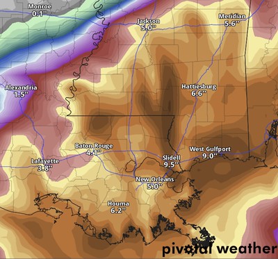
There is a stripe of more than a foot of rain across parts of south Mississippi on the ECMWF. And if I’ve learned two BIG things with forecasting rainfall from tropical systems it is that (1) There is always a stripe of heaviest rainfall and (2) the models generally under-forecast the totals for that stripe.
Well, there is a third thing, too… (3) the models never forecast stripe placement correctly.
So this is the big thing to watch in the coming days. How does that stripe of heaviest rain evolve. And what we – as meteorologists – do is track each stripe and peg down trends and see if those trends line up with other factors in the atmosphere to make an accurate forecast.
The WPC does a fantastic job at this. I’m always trying to beat them, but I can rarely do it.
TROPICAL THREAT INDEX
This remains officially unchanged. The WPC rainfall totals around 10 inches at the bullseye. But h next step up is when it exceeds 11 inches. So it is close.

This is still looking like a rainmaker. And not a massive surge producer or wind storm.


One thought on “6/14/21 Tropical Update: T.D. Two, Invest 92L and another Tropical Wave”
Comments are closed.