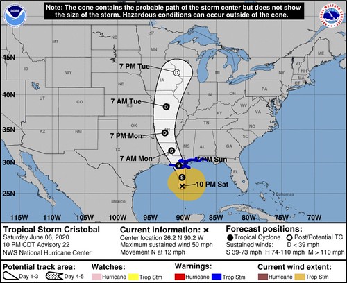
The National Hurricane Center continues to monitor Tropical Storm Cristobal as it moves north toward the Louisiana coastline. The forecast landfall will occur Sunday afternoon or evening. It is predicted to make landfall as a Tropical Storm, and not as a Hurricane.
The good news is that the storm continues to eat up the dry air that has wrapped around it. That has limited the ability for the storm to get better organized and strengthen.
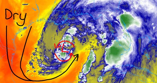
The flip side of that is that the wind field will continue to be pretty large. Right now, the Tropical Storm force wind extends 240 miles from the center of the storm.
Latest from the NHC
Cristobal has generally changed little during the past several hours. The storm continues to exhibit more of a subtropical appearance in satellite images with a broad wind field and a limited amount of deep convection near the center. The most intense convection has been in a squall line that is well east of the center near or over portions of the Florida peninsula. Data from both the NOAA and Air Force Hurricane Hunters support holding the initial wind speed at 45 kt for this advisory. The center of Cristobal recently passed very near NOAA buoy 42001 in the central Gulf of Mexico, which was helpful in assessing the storm’s minimum pressure.
Cristobal is moving northward at about 10 kt between a deep-layer ridge to its east and a mid- to upper-level trough over the western Gulf of Mexico. This general motion should continue for about another day, taking the center of the storm across the Louisiana coast by Sunday night. After the storm makes landfall, a slight turn to the northwest is expected on Monday in response to a mid-level ridge shifting eastward across the southeast U.S. The track models are in very good agreement and only small changes were made to the previous NHC forecast.
Cristobal has about another 18-24 hours over water in which it could strengthen. However, given its broad structure, lack of deep convection near the center, and dry air that is wrapping into the west and south sides of the circulation, only a little strengthening is predicted. After the storm makes landfall, steady weakening is forecast and the cyclone should weaken to a tropical depression by late Monday.
Cristobal is a broad and asymmetric storm. Therefore, one should not focus on the exact forecast track, as the associated winds, storm surge, and rainfall will extend well away the center.
Regional impacts
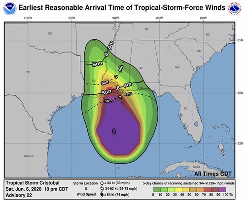
WIND:
Tropical storm conditions are expected within the Tropical Storm Warning area along the northern Gulf coast beginning Sunday morning. For other places outside of the warning areas, tropical storm force wind gusts will be possible within rain bands, but isn’t as likely to be a constant wind.
RAINFALL:
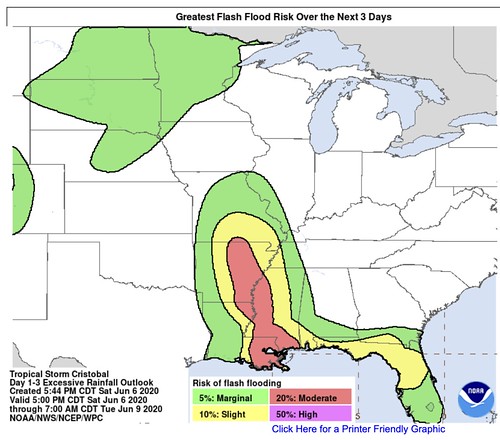
Cristobal is expected to produce total rainfall accumulations of 4 to 8 inches across the eastern and central Gulf coast into the Lower Mississippi Valley, with isolated amounts to 12 inches. Some of the highest totals look to be across parts of eastern Louisiana, southern Mississippi and southwestern Alabama. Isolated significant river flooding is possible along the central Gulf coast. Rainfall totals of 2 to 4 inches, with local amounts to 6 inches, are expected across portions of the Mid and Upper Mississippi Valley and Northern Plains near and in advance of Cristobal. This rainfall may lead to flash flooding and widespread flooding on smaller streams across the Mid-Mississippi Valley.
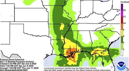
In response to the projected rainfall totals the Weather Prediction Center has highlighed parts of the area with a Moderate Risk for flash flooding.
TORNADOES:
A few tornadoes will be possible overnight into Sunday morning from eastern Louisiana, through Mississippi, Alabama and into the Florida panhandle. Tornadoes will likely be brief and fast moving. During tropical systems, tornadoes tend to be EF-0 or EF-1 in strength, but remember than any tornado can cause damage.
In response to that threat, the Storm Prediction Center has outlined parts of the area with a Slight Risk for severe weather, with the main concern being brief tornadoes

Timeline
For southeastern Louisiana, southern Mississippi and southwestern Alabama, based on the latest from the National Hurricane Center and model guidance, here is a break down with respect to start and stop times for different events.
Sunday 8am:
Passing downpours with wind gusts to 40mph possible in Louisiana, 30mph in Mississippi and 20mph in Alabama
Sunday 2pm:
Consistent rain with wind gusts to 50mph possible in Louisiana, Passing rain bands with wind gusting to 40mph in Mississippi and 30mph in Alabama.
Sunday at 8pm:
Very heavy consistent rain with wind gusts to 50mph possible in Louisiana, Consistent rain with some very heavy downpours at times for sections of southern Mississippi with wind gusting to 40mph in Mississippi, Passing rain bands with wind gusting to 30mph in Alabama. The potential for brief spin-up tornadoes in all areas
Monday at 2am:
Very heavy consistent rain with wind gusts to 50mph possible in Louisiana, very heavy consistent rain for sections of southern Mississippi with wind gusting to 40mph in Mississippi, Passing rain bands with heavy rain at times with wind gusting to 30mph in Alabama. The potential for brief spin-up tornadoes in all areas
Monday at 8am:
Rain turning to showers with wind gusts to 30mph possible in Louisiana, consistent rain, heavy at times, for sections of southern Mississippi with wind gusting to 30mph in Mississippi, Passing rain bands with heavy rain at times with wind gusting to 20mph in Alabama. The potential for brief spin-up tornadoes in all areas
Monday at 2pm:
Showers with wind gusts to 20mph possible in Louisiana, consistent rain for sections of southern Mississippi with wind gusting to 30mph in Mississippi, Passing rain bands with heavy rain at times with wind gusting to 20mph in Alabama.
Monday at 8pm:
Rain ending across the area with wind still gusting to 20mph.


