Cristobal continues to move toward Louisiana. Now located about 90 miles from New Orleans, projected to make landfall between 4pm and 7pm tonight. Cristobal will be a Tropical Storm at landfall, barring some incredible last-minute intensification.
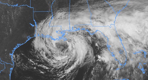
The storm is rather lopsided and most of the wind, rain and potential for tornadoes will be on the east side of the storm as it makes landfall and moves through the region.
From the NHC
Storm Stats
LOCATION…28.7N 90.0W
ABOUT 90 MI…145 KM S OF NEW ORLEANS LOUISIANA
MAXIMUM SUSTAINED WINDS…50 MPH…85 KM/H
PRESENT MOVEMENT…N OR 355 DEGREES AT 12 MPH…19 KM/H
MINIMUM CENTRAL PRESSURE…994 MB…29.36 INCHES

DISCUSSION AND OUTLOOK
At 1000 AM CDT (1500 UTC), the center of Tropical Storm Cristobal was located near latitude 28.7 North, longitude 90.0 West. Cristobal is moving toward the north near 12 mph (19 km/h), and this general motion is expected to continue today, followed by a gradual turn toward the north-northwest late today or tonight. On the forecast track, the center of Cristobal will approach the northern Gulf of Mexico coast this afternoon, then move inland across Louisiana late today through Monday morning, and northward across Arkansas and Missouri Monday afternoon into Tuesday.
Data from an Air Force Reserve reconnaissance aircraft and NOAA Doppler weather radars indicate that maximum sustained winds remain near 50 mph (85 km/h) with higher gusts. Little change in strength is forecast before landfall. Gradual weakening will begin once Cristobal moves inland.
Tropical-storm-force winds extend outward up to 205 miles (335 km),mainly to the east of the center. A Weatherflow site at Bayou Bienvenue, Louisiana, recently measured a sustained wind of 37 mph (60 km/h) and a gust to 47 mph (76 km/h).
The estimated minimum central pressure is 994 mb (29.36 inches).
INLAND CONCERNS
WIND: Tropical storm conditions are expected within the Tropical Storm Warning area along the northern Gulf coast through tonight.
RAINFALL: Cristobal is expected to produce total rainfall accumulations of 4 to 8 inches across portions of the central Gulf Coast into the Lower Mississippi Valley, with isolated amounts to 12 inches. Rainfall totals of 2 to 4 inches with local amounts to 6 inches are expected across portions of the eastern Gulf Coast, along with the Mid to Upper Mississippi Valley and Northern Plains near and in advance of Cristobal. This rainfall will likely lead to flash flooding and widespread flooding on smaller streams across portions of the central Gulf Coast into the Lower Mississippi Valley. New and renewed significant river flooding is possible along the central Gulf Coast and into the Mississippi Valley.
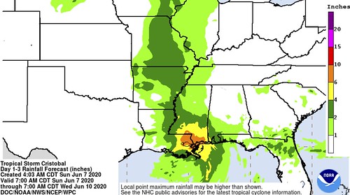
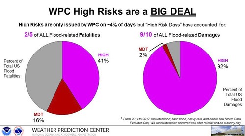
Due to the threat forheavy rain, the WPC has also included parts of the Gulf Coast in a High Risk for flash flooding.

And a quick note that a majority of flood damage and almost half of the flood-related deaths occur on High Risk days.
TORNADOES: A few tornadoes are possible today and tonight across eastern Louisiana, southern Mississippi, southern Alabama, and
northern Florida.

Timeline
For southeastern Louisiana, southern Mississippi and southwestern Alabama, based on the latest from the National Hurricane Center and model guidance, here is a break down with respect to start and stop times for different events.
Sunday 8am:
Passing downpours with wind gusts to 40mph possible in Louisiana, 30mph in Mississippi and 20mph in Alabama
Sunday 2pm:
Consistent rain with wind gusts to 50mph possible in Louisiana, Passing rain bands with wind gusting to 40mph in Mississippi and 30mph in Alabama.
Sunday at 8pm:
Very heavy consistent rain with wind gusts to 50mph possible in Louisiana, Consistent rain with some very heavy downpours at times for sections of southern Mississippi with wind gusting to 40mph in Mississippi, Passing rain bands with wind gusting to 30mph in Alabama. The potential for brief spin-up tornadoes in all areas
Monday at 2am:
Very heavy consistent rain with wind gusts to 50mph possible in Louisiana, very heavy consistent rain for sections of southern Mississippi with wind gusting to 40mph in Mississippi, Passing rain bands with heavy rain at times with wind gusting to 30mph in Alabama. The potential for brief spin-up tornadoes in all areas
Monday at 8am:
Rain turning to showers with wind gusts to 30mph possible in Louisiana, consistent rain, heavy at times, for sections of southern Mississippi with wind gusting to 30mph in Mississippi, Passing rain bands with heavy rain at times with wind gusting to 20mph in Alabama. The potential for brief spin-up tornadoes in all areas
Monday at 2pm:
Showers with wind gusts to 20mph possible in Louisiana, consistent rain for sections of southern Mississippi with wind gusting to 30mph in Mississippi, Passing rain bands with heavy rain at times with wind gusting to 20mph in Alabama.
Monday at 8pm:
Rain ending across the area with wind still gusting to 20mph.


Thanks Nick I always appreciate everything you say. Please keep up the good work wdam is my favorite