
Potential Tropical Cyclone Two Discussion Number 2
NWS National Hurricane Center Miami FL AL022019
400 PM CDT Wed Jul 10 2019
Data from An Air Force Reserve reconnaissance aircraft, surface observations, and satellite imagery indicate that the broad low pressure system located over the northeastern Gulf of Mexico still lacks a well-defined circulation center. Multiple low-level swirls associated with individual convective cells were noted in the aircraft wind data. However, shower and thunderstorm activity has been increasing over the past couple of hours in the previously convective-free northern semicircle, an indication that low-level wind field is beginning to improve in that region of the cyclone. Upper-level outflow has become well established except to the north where modest northerly wind shear is inhibiting the outflow. The initial intensity of 25 kt is based on earlier scatterometer wind data and recent recon winds of 25-30 kt to the south and west of the center.
The initial motion estimate remains 245/07 kt. The latest model guidance continues in good agreement on the cyclone moving generally toward the west-southwest or southwest for the next 24 hours or so, followed by a westward motion on Friday. Afterwards, however, the model guidance diverges significantly. The 12Z ECMWF, GFS, HWRF, and HMON models have shifted farther east and turn the cyclone northwestward to northward in 48-72 hours, moving it inland along the south-central and southeastern coasts of Louisiana. In contrast, the UKMET has shifted farther west and keeps the system on more of westward track, taking it inland along the central Texas coast. The main difference is how the models handle the ridge to the north, with the ECMWF, GFS, HWRF, and HMON rapidly eroding the ridge as a weak shortwave trough passes to the north of the cyclone, whereas the UKMET shows the ridge not weakening as much due to the shortwave trough weakening as it lifts out to the east, which allows the ridge to remain intact. Due to this significant bifurcation in NHC’s most reliable track model guidance, the best course of action is to slow down the forward speed and only make minor adjustments to the overall tack, which has been shifted slightly to the east, but not as far east as the simple consensus
and HCCA models.
Only slow strengthening is forecast for the next 24-36 hours due to the lack of a well-defined center and inner-core wind field, along with some modest northerly wind shear. By 48 hours and beyond, however, the combination of very low vertical wind shear, an impressive outflow pattern forecast by all of the global and regional models, and anomalously warm sea-surface temperatures of 30-31C should allow for significant intensification to hurricane strength before landfall occurs after 72 hours. Given that the system is still in the formative stages, the official intensity forecast remains a little below IVCN consensus through 48
hours and trends higher toward the ECMWF-based SHIPS guidance at 72 hours.
Key Messages:
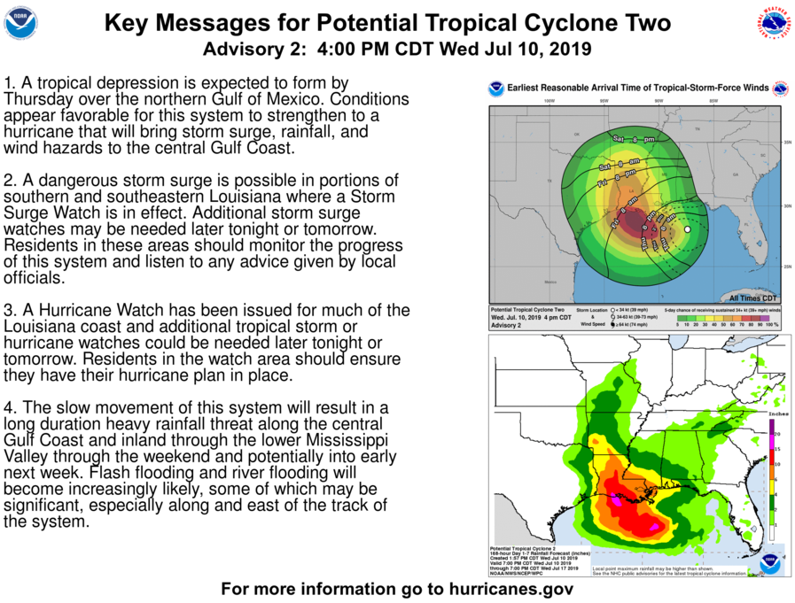
1. A tropical depression is expected to form by Thursday over the northern Gulf of Mexico. Conditions appear favorable for this system to strengthen to a hurricane that will bring storm surge, rainfall, and wind hazards to the central Gulf Coast.
2. A dangerous storm surge is possible in portions of southern and southeastern Louisiana where a Storm Surge Watch is in effect. Additional storm surge watches may be needed later tonight or tomorrow. Residents in these areas should monitor the progress of this system and listen to any advice given by local officials.
3. A Hurricane Watch has been issued for much of the Louisiana coast and additional tropical storm or hurricane watches could be needed later tonight or tomorrow. Residents in the watch area should ensure they have their hurricane plan in place.
4. The slow movement of this system will result in a long duration heavy rainfall threat along the central Gulf Coast and inland through the lower Mississippi Valley through the weekend and potentially into early next week. Flash flooding and river flooding will become increasingly likely, some of which may be significant, especially along and east of the track of the system.
FORECAST POSITIONS AND MAX WINDS
INIT 10/2100Z 28.1N 87.4W 25 KT 30 MPH…POTENTIAL TROP CYCLONE
12H 11/0600Z 27.7N 88.1W 30 KT 35 MPH…POTENTIAL TROP CYCLONE
24H 11/1800Z 27.5N 89.0W 35 KT 40 MPH…TROPICAL STORM
36H 12/0600Z 27.6N 90.2W 40 KT 45 MPH
48H 12/1800Z 28.2N 91.5W 55 KT 65 MPH
72H 13/1800Z 29.3N 92.4W 75 KT 85 MPH
96H 14/1800Z 31.9N 93.0W 55 KT 65 MPH…INLAND
120H 15/1800Z 34.8N 93.1W 25 KT 30 MPH…INLAND
…HURRICANE WATCH ISSUED FOR PORTIONS OF THE SOUTHERN COAST OF LOUISIANA…
…HEAVY RAINS EXPECTED TO CONTINUE ACROSS THE CENTRAL GULF COAST…
SUMMARY OF 400 PM CDT…2100 UTC…INFORMATION
———————————————-
LOCATION…28.1N 87.4W
ABOUT 125 MI…200 KM ESE OF THE MOUTH OF THE MISSISSIPPI RIVER
ABOUT 255 MI…410 KM ESE OF MORGAN CITY LOUISIANA
MAXIMUM SUSTAINED WINDS…30 MPH…45 KM/H
PRESENT MOVEMENT…WSW OR 245 DEGREES AT 8 MPH…13 KM/H
MINIMUM CENTRAL PRESSURE…1011 MB…29.86 INCHES
WATCHES AND WARNINGS
——————–
CHANGES WITH THIS ADVISORY…
The Storm Surge Watch has been extended westward to Intracoastal City Louisiana.
A Hurricane Watch has been issued from the Mouth of the Mississippi River westward to Cameron Louisiana.
A Tropical Storm Watch has been issued from north of the Mouth of the Mississippi River to the Mouth of the Pearl River.
SUMMARY OF WATCHES AND WARNINGS IN EFFECT…
A Storm Surge Watch is in effect for…
* Mouth of the Pearl River to Intracoastal City
A Hurricane Watch is in effect for…
* Mouth of the Mississippi River to Cameron
A Tropical Storm Watch is in effect for…
* Mouth of the Mississippi River northward to the Mouth of the Pearl
River
A Storm Surge Watch means there is a possibility of life-threatening inundation from rising water moving inland from the coastline in the indicated locations during the next 48 hours. For a depiction of areas at risk please see the National Weather Service Storm Surge Watch/Warning Graphic available at hurricanes.gov.
A Hurricane Watch means that hurricane conditions are possible within the watch area. A watch is typically issued 48 hours before the anticipated first occurrence of tropical-storm-force winds conditions that make outside preparations difficult or dangerous.
A Tropical Storm Watch means that tropical storm conditions are possible within the watch area generally within 48 hours.
Interests elsewhere along the U.S. Gulf Coast from the Upper Texas Coast to the Florida Panhandle should monitor the progress of this system.
For storm information specific to your area, including possible inland watches and warnings, please monitor products issued by your local National Weather Service forecast office.
DISCUSSION AND OUTLOOK
———————-
At 400 PM CDT (2100 UTC), the broad disturbance was centered near latitude 28.1 North, longitude 87.4 West. The system is moving toward the west-southwest near 8 mph (13 km/h). A motion toward the west-southwest or southwest is expected through Thursday morning, followed by a turn toward the west late Thursday and a turn toward the west-northwest on Friday. By early Saturday, a northwestward motion is expected. On the forecast track, the system is expected to approach the central U.S. Gulf Coast this weekend.
Reports from an Air Force Reserve reconnaissance aircraft indicate that maximum sustained winds are near 30 mph (45 km/h) with higher gusts. Strengthening is forecast during the next 72 hours, and the disturbance is forecast to become a tropical depression Thursday morning, a tropical storm Thursday night, and a hurricane on Friday.
Shower and thunderstorm activity has gradually been increasing in coverage and organization, and the low is likely to become a tropical depression or a tropical storm in the next day or so. *Formation chance through 48 hours…high…near 100 percent *Formation chance through 5 days…high…near 100 percent
The estimated minimum central pressure based on data from the aircraft and surface observations is 1011 mb (29.86 inches).
HAZARDS AFFECTING LAND
———————-
STORM SURGE: The combination of a dangerous storm surge and the tide will cause normally dry areas near the coast to be flooded by rising waters moving inland from the shoreline. The water could reach the following heights above ground somewhere in the indicated areas if the peak surge occurs at the time of high tide…
Mouth of the Pearl River to Intracoastal City…3 to 6 ft
Surge-related flooding depends on the relative timing of the surge and the tidal cycle, and can vary greatly over short distances. For information specific to your area, please see products issued by your local National Weather Service forecast office.
RAINFALL: The system is expected to produce total additional rain accumulations of 6 to 12 inches near and inland of the central Gulf Coast through early next week, with isolated maximum rainfall amounts of 18 inches.
Rainfall amounts exceeding 6 to 9 inches have already occurred across portions of the New Orleans metropolitan area today, which has resulted in flooding.
WIND: Hurricane conditions are possible within the Hurricane Watch area by Friday night, with tropical storm conditions possible by early Friday.
NEXT ADVISORY
————-
Next intermediate advisory at 700 PM CDT.
Next complete advisory at 1000 PM CDT.


