As a general rule, I don’t ‘make fun’ of others appearance. It’s rude. But with Barry, here, it isn’t as much of an opinion as it is a fact.
Barry ain’t pretty. The storm is still very unorganized and lop-sided. But that doesn’t mean the Gulf Coast region is in the clear. It just means it doesn’t have the typical Tropical Storm look.
It is still going to rain. A bunch.
The latest on Barry

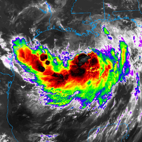
I say that Barry is ugly, the NHC says that Barry “does not have the typical presentation of a tropical cyclone on satellite imagery” right now. As you can see from the image above most of thunderstorm activity is on the south and east side of the center of circulation as the storm is still battling northerly shear. Most of the tropical-storm-force wind is occurring in the eastern semicircle.
Philippe Pappin discussed why Barry would never reach hurricane strength last night on Twitter.
Thought I’d make another loop illustrating features affecting #Barry as it tracks closer to Louisiana.
Shear & Dry Air from an upper-level ridge + PV streamer should continue to keep Barry asymmetrical up to landfall.
Slow deepening may continue but RI is now unlikely. pic.twitter.com/1Y2guzdepP
— Philippe Papin (@pppapin) July 12, 2019
Once Barry started eating all of that dry air that got lodged between the ridges, there was a ‘lid’ put on just how strong it would get.
Even looking at the Rapid Intensification numbers is showing that RI is looking less and less likely:

The Hurricane Hunters are headed back out into the storm a few more times today before landfall. The last go-around the HH sampled the area found 51 kt wind at flight level. That means SFMR wind of 43 kt at the surface. So the NHC kept the 50mph wind speed for the 7AM advisory.
From the NHC Discussion:
Barry is moving over warm waters of about 30 degrees Celsius, and still has the opportunity to strengthen. Although the NHC intensity forecast again does not explicitly show Barry becoming a hurricane, it is still possible for that to occur before landfall in about 24 hours. Most of the models show modest strengthening despite the northerly shear and the effect of the dry air. After landfall, steady weakening is anticipated.
The broad center of circulation appears to be moving slowly toward the west-northwest or 295 degrees at 4 kt. This is taking the average motion of the several swirls rotating around a larger circulation. The cyclone should soon begin to turn toward the northwest and then northward around the periphery of a mid-level ridge. The overall guidance has changed very little and the NHC forecast is not different from the previous one. It is in the middle of the guidance envelope and very close to the multi-model consensus.
In short, the likelihood of Barry becoming a hurricane now are quite low. However, that doesn’t change much for the impacts.
No time for science! There’s a Tropical Storm a’makin landfall!
The coastline of Louisiana may be the only place that benefits from an ugly, disorganized Barry. For everyone else, there isn’t much of a change to the forecast.
Rainfall is going to be the greatest concern for those who are not along the immediate coastline. The Weather Prediction Center has issued a High Risk (that a four on their one-to-four scale where four is the highest risk) for flash flooding Satruday across parts of central Louisiana. You can see why with this rainfall forecast:

The WPC is still showing a stretch of 10″ to 20″ of rain through parts of central Louisiana.
What does this all mean for you?
This is probably a good reminder that looks aren’t everything. In all walks of life. But for today, definitely for tropical systems. Also, make sure if you life in a place that floods that you have an evacuation plan.
Rain
Parts of Louisiana and Mississippi are going to get drenched with about 4 inches to 20 inches of rain. With some spots picking up as much as 25 inches of rain. And there could be some places that get even more, depending on how the feeder bands set up.
I know 4 inches to 20 inches is a pretty wide spread, but across the region, that is going to be the spread.
Model guidance continues to show the potential for even more rainfall in some places this morning. And I anticipate the WPC will continue to increase the rainfall forecast as they did this morning from last night.

Here is another look at the list of places I’ve been tracking with updated rainfall estimates based on the latest model guidance, and not the official forecast from the WPC:
Louisiana
New Orleans – 10+ inches
Baton Rouge – 12+ inches
Lafayette – 4+ inches
Alexandria – 4+ inches
Lake Charles – 3+ inches
Shreveport – 2+ inches
Mississippi
Gulfport – 7+ inches
Hattiesburg – 7+ inches
McComb – 8+ inches
Jackson – 5+ inches
Meridian – 6+ inches
Tupelo – 5+ inches
Alabama
Mobile – 5+ inches
Montgomery – 1+ inches
Birmingham – 1+ inches
Huntsville – 1+ inches

This is mainly going to be a Louisiana and Mississippi event during the first 48 hours. After that point there may be flooding across parts of the Ohio River valley, depending on track.
Wind
Hurricane-force wind won’t be as much of a concern inland. Instead, Tropical Storm-force wind will be the concern for inland areas of Louisiana and Mississippi.

In fact, the official NHC forecast keeps Barry as a Tropical Storm until landfall. But, even if it does strengthen, the hurricane-force wind will only be felt along the immediate coastline within 10 to 20 miles of landfall – if not even closer. Everywhere else can anticipate weaker wind. And the further inland you travel, the weaker the wind will be.
Tropical-storm-force winds extend outward up to 175 miles to the east of the center. An United States Geological Survey
station near Point a la Hache, Louisiana recently reported sustained winds of 38 mph. Keep in mind, once this moves ashore, there is a chance the tropical storm-force wind field spreads out a bit. That means up to 40mph wind possible even further away from the center.
Surge
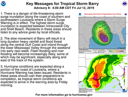
This is what the NHC warns:
The combination of a dangerous storm surge and the tide will cause normally dry areas near the coast to be flooded by rising waters moving inland from the shoreline. The water could reach the following heights above ground somewhere in the indicated areas if the peak surge occurs at the time of high tide…
Surge-related flooding depends on the relative timing of the surge and the tidal cycle, and can vary greatly over short distances. For information specific to your area, please see products issued by your local National Weather Service forecast office.
Forecast:
Mouth of the Atchafalaya River to Shell Beach…3 to 6 ft
Shell Beach to the Mississippi/Alabama border…2 to 4 ft
Intracoastal City to the Mouth of the Atchafalaya River…3 to 5 ft
Lake Pontchartrain…2 to 4 ft
Timeline
This is a very slow moving system that is trapped between three different amtospheric features. It isn’t going to be in a hurry to do anything – move or strengthen.
Storm timeline
Friday – Continues as a Tropical Storm, given latest model data, south of Louisiana moving northwest approaching land with some strengthening possible, but not likely
Saturday – Makes landfall as a Tropical Storm somewhere between Lake Charles, Louisiana and New Orleans, Louisiana and moves north
Sunday – Inland
Impacts Timeline for South of I-20
Friday – Storms in Louisiana, Mississippi and Alabama associated with Barry, some flooding possible along the coast withing 40 miles of the Gulf across parts of Louisiana and Mississippi
Saturday – Heavy rain in Louisiana and Mississippi associated with Barry, flooding likely, downed trees possible, power outages possible, tornadoes also possible
Sunday – Heavy rain in Louisiana and Mississippi associated with Barry, flooding likely, downed trees possible, power outages possible, tornadoes also possible
Because the storm is so lop-sided right now, it is difficult to tell you exactly when rain or wind will begin a specific location.
How can I prepare now, Nick?
If you live in a flood-prone area, assess your surroundings. Is the creek near your house clear of debris? Are the storm drains clogged? Fix those things now. If a Flash Flood Emergency was issued for your area, do you know where to go? Find a safe place from flooding now.
Don’t feel safe in your home during bad weather? Reach out to a friend! Go hang out at their place this weekend.
While this isn’t anticipated to be some Monster Hurricane, prolonged rain can cause serious problems. Flooding is the deadliest form of severe weather. It kills more people than tornadoes. So please take it seriously.
Also check your Hurricane Preparedness Kit. That’s about it. Make sure you have enough supplies to last a few days without power and water. Not because this system is anticipated to wipe out power and water to an area, but rather, you should always have enough supplies to last a few days without power and water during Hurricane season.


