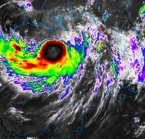
Barry is starting to look a bit healthier, though is still objectively disorganized. The blow-up of convection near the center has led to strengthening.
From the National Hurricane Center
Location and Strength
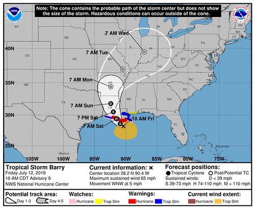
LOCATION…28.2N 90.4W
ABOUT 100 MI…160 KM SW OF THE MOUTH OF THE MISSISSIPPI RIVER
ABOUT 115 MI…185 KM SSE OF MORGAN CITY LOUISIANA
MAXIMUM SUSTAINED WINDS…65 MPH…100 KM/H
PRESENT MOVEMENT…WNW OR 290 DEGREES AT 5 MPH…7 KM/H
MINIMUM CENTRAL PRESSURE…998 MB…29.47 INCHES
Key Messages
1. There is a danger of life-threatening storm surge inundation along the coast of southern and southeastern Louisiana, portions of Lake Pontchartrain, and portions of coastal Mississippi where a Storm Surge Warning is in effect. Water levels are already beginning to rise in these areas, with the peak inundation expected on Saturday. The highest storm surge inundation is expected between Intracoastal City and Shell Beach.
2. The slow movement of Barry will result in a long duration heavy rainfall and flood threat along the central Gulf Coast, across portions of the Lower Mississippi Valley and north into the Tennessee Valley through the weekend into early next week. Flash flooding and river flooding will become increasingly likely, some of which may be life-threatening, especially across portions of southeast Louisiana into Mississippi.
3. Hurricane conditions are expected along a portion of the coast of Louisiana, where a Hurricane Warning is in effect. Tropical storm conditions are expected elsewhere along much of the Louisiana coast and inland across portions of south-central Louisiana where tropical storm warnings are in effect.
Watches and Warnings
CHANGES WITH THIS ADVISORY…
A Storm Surge Warning has been issued for Lake Pontchartrain and east of Shell Beach to Biloxi Mississippi.
SUMMARY OF WATCHES AND WARNINGS IN EFFECT…
A Hurricane Warning is in effect for…
* Intracoastal City to Grand Isle
A Tropical Storm Warning is in effect for…
* Mouth of the Pearl River to Grand Isle
* Lake Pontchartrain and Lake Maurepas including metropolitan New Orleans
* Intracoastal City to Cameron
A Storm Surge Warning is in effect for…
* Intracoastal City to Biloxi
* Lake Pontchartrain
A Storm Surge Watch is in effect for…
* Biloxi to the Mississippi/Alabama border
A Hurricane Watch is in effect for…
* Mouth of the Mississippi River to Grand Isle
* Intracoastal City to Cameron
A Tropical Storm Watch is in effect for…
* East of the Mouth of the Pearl River to the Mississippi/Alabama border
A Hurricane Warning means that hurricane conditions are expected somewhere within the warning area. A warning is typically issued 36 hours before the anticipated first occurrence of tropical-storm-force winds, conditions that make outside preparations difficult or dangerous. Preparations to protect life and property should be rushed to completion.
A Tropical Storm Warning means that tropical storm conditions are expected somewhere within the warning area within 36 hours.
A Storm Surge Warning means there is a danger of life-threatening inundation from rising water moving inland from the coastline during the next 36 hours in the indicated locations. For a depiction of areas at risk please see the National Weather Service Storm Surge Watch/Warning Graphic available at hurricanes.gov. This is a life-threatening situation. Persons located within these areas should take all necessary actions to protect life and property from rising water and the potential for other dangerous conditions. Promptly follow evacuation and other instructions from local officials.
A Storm Surge Watch means there is a possibility of life-threatening inundation from rising water moving inland from the
coastline in the indicated locations during the next 48 hours.
A Hurricane Watch means that hurricane conditions are possible within the watch area. A watch is typically issued 48 hours before the anticipated first occurrence of tropical-storm-force winds conditions that make outside preparations difficult or dangerous.
A Tropical Storm Watch means that tropical storm conditions are possible within the watch area generally within 48 hours.
Interests elsewhere along the Gulf Coast from the Upper Texas Coast to the Florida Panhandle should monitor the progress of this system.
For storm information specific to your area, including possible inland watches and warnings, please monitor products issued by your local National Weather Service forecast office.
Main concerns inland
Key Messages for Barry can be found in the Tropical Cyclone Discussion under AWIPS header MIATCDAT2 and WMO header WTNT42 KNHC.
STORM SURGE:
The combination of a dangerous storm surge and the tide will cause normally dry areas near the coast to be flooded by rising waters moving inland from the shoreline. The water could reach the following heights above ground somewhere in the indicated areas if the peak surge occurs at the time of high tide…
Mouth of the Atchafalaya River to Shell Beach…3 to 6 ft
Shell Beach to Biloxi MS…3 to 5 ft
Intracoastal City to the Mouth of the Atchafalaya River…3 to 5 ft
Lake Pontchartrain…3 to 5 ft
Biloxi MS to the Mississippi/Alabama border…2 to 4 ft
Lake Maurepas…1 to 3 ft

Surge-related flooding depends on the relative timing of the surge and the tidal cycle, and can vary greatly over short distances. For information specific to your area, please see products issued by your local National Weather Service forecast office.
RAINFALL:
Barry is expected to produce total rain accumulations of 10 to 20 inches over south-central and southeast Louisiana along with southwest Mississippi, with isolated maximum amounts of 25 inches. These rains are expected to lead to dangerous, life threatening flooding over portions of the central Gulf Coast into the Lower Mississippi Valley.

Over the remainder of the Lower Mississippi Valley, total rain accumulations of 4 to 8 inches are expected, with isolated maximum amounts of 12 inches.
WIND:
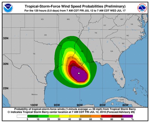
Hurricane conditions are expected in the Hurricane Warning area tonight or Saturday, with tropical storm conditions beginning during the next several hours. Hurricane conditions are possible within the Hurricane Watch area by tonight or Saturday morning. Tropical storm conditions are spreading across the Tropical Storm Warning area in southeastern Louisiana at this time. Tropical storm conditions are possible in the Tropical Storm Watch area by tonight or Saturday. Wind gusts to tropical-storm force in squalls are possible along portions of the coasts of Alabama and the western Florida Panhandle through Saturday night.
TORNADOES:
A couple tornadoes are possible this afternoon through tonight across southeast Louisiana, far southern Mississippi, and the Alabama coast.
Forecaster Discussion
Reports from Air Force Reserve and NOAA Hurricane Hunter aircraft indicate that Barry has strengthened during the past several hours. The Air Force plane reported maximum 850-mb flight-level winds of 62 kt and reliable-looking SFMR winds of 50-55 kt in the strong convection that has developed in the southern quadrant. In addition, the data from both planes indicate the central pressure has fallen to near 998 mb. Based on these data, the initial intensity is increased to 55 kt. Data from the NOAA plane, which is flying near 460 mb, shows that the center at that level is south of the low-level center, likely due to ongoing northerly shear.
The initial motion is an erratic 290/4. While there is still a larger than normal spread between the UKMET on the left ide and the HWRF on the right side, the track guidance has come into better agreement that Barry will turn northwestward later today or tonight, with this motion continuing until the center makes landfall along the Louisiana coast in 24-30 h. After landfall, the system should move northward through a break in the ridge of high pressure over the United States until the 72 h point, after which it should recurve northeastward into the westerlies. The new track forecast has only minor tweaks from the previous forecast, and it lies near the various consensus models.
Barry has been strengthening despite an asymmetric convective structure, ongoing northerly shear, and the presence of mid- to upper-level dry air over the northern semicircle. The intensity guidance suggests that, while the environment will be at best marginally favorable, the cyclone will continue to intensify until landfall. Based on this, the new intensity forecast calls for Barry to become a hurricane in 24 h, just before landfall, with this forecast being slightly above the guidance. After landfall, the cyclone should steadily weaken, with decay to a remnant low forecast to occur in about 72 h.
Forecast position and wind speed
INIT 12/1500Z 28.2N 90.4W 55 KT 65 MPH
12H 13/0000Z 28.6N 90.9W 60 KT 70 MPH
24H 13/1200Z 29.4N 91.5W 65 KT 75 MPH
36H 14/0000Z 30.5N 92.0W 45 KT 50 MPH…INLAND
48H 14/1200Z 31.8N 92.4W 30 KT 35 MPH…INLAND
72H 15/1200Z 34.4N 92.4W 20 KT 25 MPH…POST-TROP/REMNT LOW
96H 16/1200Z 37.0N 90.5W 20 KT 25 MPH…POST-TROP/REMNT LOW
120H 17/1200Z 39.5N 87.0W 20 KT 25 MPH…POST-TROP/REMNT LOW


