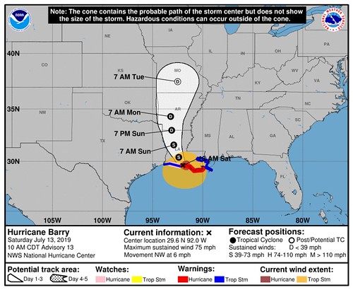
Alrighty friends, I’m starting to get a lot of questions about specifics. And, sadly, I don’t have time to go one-by-one and answer everyone’s questions. So, I will try to get as specific as I can about threats and timeline for South Mississippi. And hopefully this will answer your questions.
A quick reminder: We never expected hurricane conditions for the Pine Belt. This continues to be a rain event with some gusty wind. The forecast has always been for on-again-off-again heavy rain on the eastern side of Barry, we never expected a hurricane here. This isn’t a ‘crazy’ storm for us. It will actually be pretty boring. Rain – heavy at times – with a sustained win between 10mph and 30mph. Perhaps a few tornadoes, but they will be very brief and weak.
Rainfall totals will be between 3″ and 8″ with some spots seeing as much as 12″ of rain. Unfortunately, I can’t tell you how much exact rain your specific location will receive. Nor can I tell you how strong the wind at your exact location will be.
Timeline
Saturday
Now – 12pm || Rainbands to the east will migrate back to the west and overtake the area. The rain will be heavy at times, but now the real heavy rain we expect later Saturday. Winds will be between 10-20mph with gusts to 30mph
12pm – 6pm || Heavier rainbands move through the area as Barry continues to move inland. Winds will be between 10-20mph with gusts to 40mph
6pm – 12am || Heavier rainbands move through the area as Barry continues to move inland. Winds will be between 15-30mph with gusts to 45mph. This is the first time where the tornado threat begins to increase slightly
Sunday
12am – 6am || Heavier rainbands move through the area as Barry continues to move inland. Winds will be between 15-30mph with gusts to 45mph. There will also be the chance for very brief spin-up tornadoes.
6am – 12pm || Heavier rainbands move through the area as Barry continues to move inland. Winds will be between 10-20mph with gusts to 35mph. There will also be the chance for very brief spin-up tornadoes.
12pm – 6pm || Heavier rainbands move through the area as Barry continues to move inland. Winds will be between 10-20mph with gusts to 35mph. There will also be the chance for very brief spin-up tornadoes.
6pm – 12am || Heavy rain eases to just rain as Barry continues to move inland. Winds will be between 10-20mph with gusts to 30mph. There will also be the chance for very brief spin-up tornadoes.
Rainfall estimates
This is where I can try to get a bit more specific, but please know that these estimates will be highly dependent on where rainbands set up. I’m making a forecast based on where radar / satellite trends show the heaviest ones to form. If I’m off by as little as a few miles, these forecast totals could change drastically. Like, really drastically.
By County clumps
Clarke and Wayne – 2″ to 4″
Jasper – 3″ to 5″
Smith, Simpson, Covington, and Jeff Davis – 4″ to 8″
Jones, Forrest and Perry – 3″ to 7″
Greene and George – 3″ to 6″
Stone and Pearl River – 5″ to 8″
Lamar and Marion – 4″ to 8″
Walthall and Lawrence – 6″ tp 10″
And again, should the rainbands shift position, these totals would change.


