
I mean, does anyone ever really want to get off the water and go back on land? It is so nice in the Gulf! Warm water. Open spaces.
Can you blame Barry for moseying around near the coast?
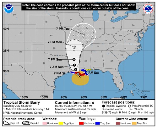
From the National Hurricane Center
SUMMARY OF 700 AM CDT…1200 UTC…INFORMATION
———————————————-
LOCATION…29.3N 91.9W
ABOUT 50 MI…80 KM WSW OF MORGAN CITY LOUISIANA
ABOUT 60 MI…95 KM S OF LAFAYETTE LOUISIANA
MAXIMUM SUSTAINED WINDS…70 MPH…115 KM/H
PRESENT MOVEMENT…NW OR 305 DEGREES AT 5 MPH…7 KM/H
MINIMUM CENTRAL PRESSURE…991 MB…29.26 INCHES
The National Hurricane Center and the Hurricane Hunters continue to track / monitor Tropical Storm Barry. The HH have another flight into teh storm scheduled for this morning to see if Barry every attains hurricane strength.
Key Messages for Barry can be found in the Tropical Cyclone Discussion under AWIPS header MIATCDAT2 and WMO header WTNT42 KNHC.
Main Concerns
STORM SURGE: The combination of a dangerous storm surge and the tide will cause normally dry areas near the coast to be flooded by rising waters moving inland from the shoreline. The water could reach the following heights above ground somewhere in the indicated areas if the peak surge occurs at the time of high tide…
Intracoastal City to Shell Beach…3 to 6 ft
Shell Beach to Biloxi MS…3 to 5 ft
Lake Pontchartrain…3 to 5 ft
Biloxi MS to the Mississippi/Alabama border…2 to 4 ft
Lake Maurepas…1 to 3 ft
Surge-related flooding depends on the relative timing of the surge and the tidal cycle, and can vary greatly over short distances. For information specific to your area, please see products issued by your local National Weather Service forecast office.
RAINFALL: Barry is expected to produce total rain accumulations of 10 to 20 inches over south-central and southeast Louisiana and southwest Mississippi, with isolated maximum amounts of 25 inches. These rains are expected to lead to dangerous, life threatening flooding over portions of the central Gulf Coast into the Lower Mississippi Valley beginning as early as later this morning. Across the remainder of the Lower Mississippi Valley, total rain accumulations of 4 to 8 inches are expected, with isolated maximum amounts of 12 inches. By early next week, Barry is expected to produce rainfall accumulations of 4 to 8 inches across western portions of the Tennessee Valley.
WIND: Hurricane conditions are expected in the Hurricane Warning area later this morning, with tropical storm conditions currently spreading across the area. Hurricane conditions are possible within the Hurricane Watch area later this morning. Tropical storm conditions are occurring across the Tropical Storm Warning area in southeastern Louisiana at this time. Tropical storm conditions are possible in the Tropical Storm Watch area later today Wind gusts to tropical-storm force in squalls are possible along portions of the coasts of Alabama and the western Florida Panhandle through tonight.
TORNADOES: A few tornadoes are possible through tonight across the southeast Louisiana, southern Mississippi, and southern Alabama.
Forecast Timeline for Gulf Coast
Storm timeline
Saturday – Makes landfall as a Tropical Storm / weak Hurrricane somewhere between Lake Charles, Louisiana and New Orleans, Louisiana and moves north
Sunday – Inland, raining itself out
Impacts Timeline for South of I-20
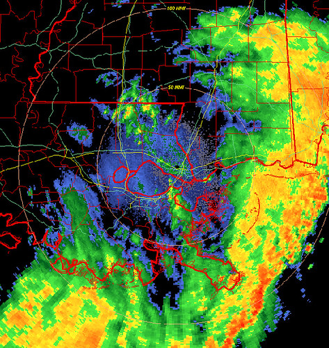
Saturday AM – First outer rainbands start to move ashore across Louisiana, Mississippi and Alabama with heavy rain, localized flooding. Gusty wind is also possible inland, but the strongest wind will be localized to the coastal areas.
Saturday PM – Heavier rain begins for Louisiana and Mississippi associated with the inner rainbands Barry. Flooding is likely, downed trees are possible, power outages are possible, tornadoes are also possible during this time.
Sunday AM – Heavy rain continues in Louisiana and Mississippi associated with Barry. Flooding continues to be likely. Other threats that are possible: downed trees, power outages, a few tornadoes.
Sunday PM – Heavy rain continues over the same areas with flooding likely. Other threats that are possible: downed trees, power outages, a few tornadoes.

Because the storm is so lop-sided right now, it is difficult to tell you exactly when rain or wind will begin a specific location.
Tropical Storm-force wind does extend nearly 175 miles away from the center, so breezy conditions will be felt far from the center of the storm.
Rainfall Forecast</strong
This is based on latest satellite imagery, radar trends, forecast model updates and the WPC forecast. The XX+ indicates at least XX amount of rainfall is likely.
Louisiana
New Orleans – 8+ inches
Baton Rouge – 12+ inches
Lafayette – 5+ inches
Alexandria – 5+ inches
Lake Charles – 4+ inches
Shreveport – 2+ inches
Mississippi
Gulfport – 7+ inches
Hattiesburg – 6+ inches
McComb – 8+ inches
Jackson – 5+ inches
Meridian – 4+ inches
Tupelo – 5+ inches
Alabama
Mobile – 3+ inches
Montgomery – 1+ inches
Birmingham – 1+ inches
Huntsville – 1+ inches
It is tough to nail down specifics given Barry’s slow movement and lop-sided nature.
How can I prepare now, Nick?
If you live in a flood-prone area, assess your surroundings. Is the creek near your house clear of debris? Are the storm drains clogged? Fix those things now. If a Flash Flood Emergency was issued for your area, do you know where to go? Find a safe place from flooding now.
Don’t feel safe in your home during bad weather? Reach out to a friend! Go hang out at their place this weekend.
While this isn’t anticipated to be some Monster Hurricane, prolonged rain can cause serious problems. Flooding is the deadliest form of severe weather. It kills more people than tornadoes. So please take it seriously.
Also check your Hurricane Preparedness Kit. That’s about it. Make sure you have enough supplies to last a few days without power and water. Not because this system is anticipated to wipe out power and water to an area, but rather, you should always have enough supplies to last a few days without power and water during Hurricane season.
Here is another look at the list of places I’ve been tracking with updated rainfall estimates based on the latest model guidance, and not the official forecast from the WPC:


